List of Utah State Parks

Hold cursor over locations to display park name;
click to go to park article.
Utah State Parks is the common name for the Division of Utah State Parks and Recreation;[1] a division of the Utah Department of Natural Resources. This is the state agency that manages the state park system of the U.S. state of Utah.
Utah's state park system began with four heritage parks in 1957: Sugar House Park (which was later removed from the system), Utah Territorial Statehouse in Fillmore, This Is the Place Monument in Salt Lake City, and Camp Floyd outside of Lehi. Today, there are 43 Utah State Parks and several undeveloped areas totaling over 95,000 acres (380 km2) of land and more than one million surface acres of water. Utah's state parks are scattered throughout Utah; from Bear Lake State Park at the Utah/Idaho border to Edge of the Cedars State Park Museum deep in the Four Corners region, and everywhere in between.
The Division of Utah State Parks and Recreation also administers the Utah off highway vehicle, boating, and trails programs. In this capacity, they work to provide access to waterways and trails, and promote education, safety, and resource protection.[2]
The division's mission statement is "To enhance the quality of life by preserving and providing natural, cultural, and recreational resources for the enjoyment, education, and inspiration of this and future generations."

A herd of bison on Antelope Island 


Sand pipe, Kodachrome Basin State Park
| Park Name | Web- site |
County or Counties | Area in Acres (ha)[3] | Elevation[4] | Date Opened[4] |
Remarks[4] |
|---|---|---|---|---|---|---|
| Anasazi State Park Museum | Garfield | 6 acres (2.4 ha) | 6,700 ft (2042 m) | 1970 | Interprets a large Ancestral Puebloan village occupied from AD 1160 to 1235. | |
| Antelope Island State Park | Davis | 22,022 acres (11340 ha) | 5,308 ft (1618 m) | 1969 | Protects Antelope Island, the largest island in the Great Salt Lake and habitat for bison, Pronghorn, and bighorn sheep. | |
| Bear Lake State Park | Rich | 5,900 ft (1798 m) | 1962 | Comprises three units on Bear Lake. | ||
| Camp Floyd / Stagecoach Inn State Park and Museum | Utah | 40 acres (16 ha) | 4,877 ft (1487 m) | 1958 | Interprets sites from the time of a massive 1858-1861 U.S. Army camp prompted by fear of the Utah War. | |
| Coral Pink Sand Dunes State Park | Kane | 3,730 acres (1510 ha) | 6,000 ft (1829 m) | 1963 | Preserves the only dune field on the Colorado Plateau, with a unique color caused by iron oxides and minerals in the Navajo sandstone. | |
| Dead Horse Point State Park | Grand and San Juan | 5,300 acres (2145 ha)[5] | 5,900 ft (1798 m) | 1959 | Showcases views of the Colorado River and Canyonlands National Park from a finger of land once used as a horse corral. | |
| Deer Creek State Park | Wasatch | 3,260 acres (1319 ha) | 5,400 ft (1646 m) | 1971 | Adjoins the extremely popular 2,965-acre (1,200 ha) Deer Creek Reservoir. | |
| East Canyon State Park | Morgan | 267 acres (108 ha) | 5,700 ft (1737 m) | 1962 | Features a reservoir in a canyon first traversed by the Donner Party and soon thereafter by Mormon pioneers. | |
| Edge of the Cedars State Park Museum | San Juan | 16 acres (6.5 ha) | 6,200 ft (1890 m) | 1978 | Interprets an Ancestral Puebloan village occupied from AD 825 to 1125. | |
| Escalante Petrified Forest State Park | Garfield | 1,350 acres (546 ha) | 5,900 ft (1798 m) | 1976 | Features petrified wood and other fossils plus a recreational reservoir. | |
| Flight Park State Recreation Area | Salt Lake and Utah | 147 acres (60 ha)[6] | 5,146 ft (1569 m) | 2006 | Offers one of the world's best training sites for hang gliding and parasailing, plus a modelport for radio control aircraft. | |
| Fremont Indian State Park and Museum | Sevier | 889 acres (360 ha) | 5,900 ft (1798 m) | 1987 | Preserves rock art and artifacts from the largest Fremont culture village yet discovered. | |
| Frontier Homestead State Park Museum | Iron | 11 acres (4 ha) | 5,800 ft (1768 m) | 1973 | Preserves historic structures and equipment from the 1850s to the 1920s, including Old Iron Town and an extensive collection of horse-drawn vehicles. Formerly called Iron Mission State Park. | |
| Goblin Valley State Park | Emery | 3,654 acres (1479 ha) | 5,000 ft (1524 m) | 1974 | Showcases an unearthly landscape of hoodoos and other rock formations. | |
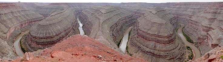
| Goosenecks State Park | San Juan | 10 acres (4 ha) | 4,500 ft (1372 m) | 1962 | Overlooks some dramatic meanders of the San Juan River. | |
| Great Salt Lake State Park | Salt Lake | 162 acres (66 ha)[7] | 4,200 ft (1280 m) | 1978 | Maintains a public boat launch and 320-slip marina on the Great Salt Lake. | |
| Green River State Park | Emery | 53 acres (21 ha) | 4,050 ft (1234 m) | 1965 | Features a shady campground, nine-hole golf course, and float trip launching on the Green River. | |
| Gunlock State Park | Washington | 549 acres (222 ha) | 3,600 ft (1097 m) | 1970 | Adjoins a 266-acre (108 ha) reservoir. | |
| Historic Union Pacific Rail Trail State Park | Summit | 450 acres (182 ha) | 6,900 ft (2103 m) | 1992 | Comprises a 28-mile (45 km) rail trail on a route used by the Union Pacific Railroad from 1880 to 1989. | |
| Huntington State Park | Emery | 111 acres (45 ha) | 5,840 ft (1780 m) | 1966 | Features a warm-water reservoir. | |
| Hyrum State Park | Cache | 264 acres (107 ha) | 4,700 ft (1433 m) | 1959 | Surrounds a 450-acre (180 ha) reservoir. | |
| Jordan River Off-Highway Vehicle State Recreation Area | Salt Lake | 350 acres (142 ha)[8] | 4,700 ft (1433 m) | 2002 | Offers four tracks for off highway vehicles along the Jordan River. | |
| Jordanelle State Park | Wasatch | 6,166 ft (1879 m) | 1995 | Comprises two recreation areas on Jordanelle Reservoir. | ||
| Kodachrome Basin State Park | Kane | 2,240 acres (906 ha) | 5,800 ft (1768 m) | 1963 | Showcases 67 rock spires and other geologic wonders in a basin so photogenic it was named after Kodachrome film. | |
| Millsite State Park | Emery | 638 acres (258 ha) | 6,100 ft (1859 m) | 1971 | Features a reservoir and lands for off highway vehicles and mountain biking. | |
| Otter Creek State Park | Piute | 80 acres (32 ha) | 5,900 ft (1798 m) | 1964 | Features a 3,120-acre (1,260 ha) reservoir, begun in 1897 as one of the earliest dam projects in Utah. | |
| Palisade State Park | Sanpete | 64 acres (26 ha) | 5,800 ft (1768 m) | 1962 | Features a reservoir and 18-hole golf course on the former site of a private resort founded in the 1860s. | |
| Piute State Park | Piute | 40 acres (16 ha) | 5,900 ft (1798 m) | 1963 | Protects a quiet fishing reservoir on the Sevier River. | |
| Quail Creek State Park | Washington | 3,300 ft (1006 m) | 1986 | Adjoins a 600-acre (240 ha) reservoir surrounded by red rock desert. | ||
| Red Fleet State Park | Uintah | 1,963 acres (794 ha)[9] | 5,500 ft (1676 m) | 1988 | Features a 750-acre (300 ha) reservoir and a fossil trackway of dinosaur footprints. | |
| Rockport State Park | Summit | 550 acres (223 ha) | 6,000 ft (1829 m) | 1966 | Features a 1,080-acre (440 ha) reservoir. | |
| Sand Hollow State Park | Washington | 20,611 acres (8341 ha)[10] | 3,000 ft (914 m) | 2003 | Features a 1,322-acre (535 ha) reservoir and an extensive off highway vehicle recreation area. | |
| Scofield State Park | Carbon | 7,600 ft (2316 m) | 1965 | Features a 2,800-acre (1,100 ha) reservoir. | ||
| Snow Canyon State Park | Washington | 7,400 acres (2995 ha)[11] | 3,100 ft (945 m) | 1962 | Showcases a canyon carved out of colorful Navajo sandstone and landforms created by the Santa Clara Volcano. | |
| Starvation State Park | Duchesne | 3,500 acres (1416 ha) | 5,700 ft (1737 m) | 1972 | Features a 3,495-acre (1,414 ha) reservoir where early settlers once struggled against starvation. | |
| Steinaker State Park | Uintah | 2,283 acres (924 ha) | 5,500 ft (1676 m) | 1964 | Features an 820-acre (330 ha) reservoir. | |
| This Is the Place Heritage Park | Salt Lake | 450 acres (182 ha) | 4,921 ft (1500 m)[12] | 1957 | Interprets Utah's settlement era with a living history village and This Is the Place Monument. | |
| Territorial Statehouse State Park Museum | Millard | 3 acres (1.2 ha) | 5,100 ft (1554 m) | 1957 | Interprets the capitol of Utah Territory, the state's oldest government building, constructed between 1852 and 1855. | |
| Utah Field House of Natural History State Park Museum | Uintah | 2 acres (0.8 ha) | 5,300 ft (1615 m) | 1959 | Houses a state-owned museum of natural history. | |
| Utah Lake State Park | Utah | 308 acres (125 ha) | 4,500 ft (1372 m) | 1970 | Adjoins Utah Lake, the state's largest body of fresh water. | |
| Wasatch Mountain State Park | Wasatch | 21,592 acres (8738 ha)[13] | 5,900 ft (1798 m) | 1968 | Features extensive recreational developments, including facilities built for the 2002 Winter Olympics. | |
| Willard Bay State Park | Box Elder | 4,200 ft (1280 m) | 1966 | Provides water recreation opportunities on a 9,900-acre (4,000 ha) freshwater reservoir on the floodplain of the Great Salt Lake. | ||
| Yuba State Park | Juab and Sanpete | 15,940 acres (6451 ha)[14] | 5,100 ft (1554 m) | 1970 | Features a reservoir on the Sevier River. | |

References
![]() This article incorporates public domain material from the website of the Division of Utah State Parks and Recreation.
This article incorporates public domain material from the website of the Division of Utah State Parks and Recreation.
- ↑ "Division of Utah State Parks and Recreation ("Utah State Parks")". State of Utah. Retrieved 2010-10-11.
- ↑ "What We Manage". Utah State Parks.
- ↑ All data come from respective Utah.com webpage unless otherwise noted.
- 1 2 3 All data come from respective Utah State Parks webpage unless otherwise noted.
- ↑ "Dead Horse Point State Park Resource Management Plan" (PDF). Utah State Parks. April 2007. Retrieved 2011-02-12.
- ↑ "Flight Park State Recreation Area: Area Management Plan" (PDF). Utah State Parks. March 2008. Retrieved 2011-02-05.
- ↑ "Great Salt Lake State Marina Resource Management Plan" (PDF). Utah State Parks. April 2007. Retrieved 2011-02-22.
- ↑ "Great Salt Lake State Park - Jordan River Shared Use Area: Area Management Plan" (PDF). Utah State Parks. November 2002. Retrieved 2011-02-08.
- ↑ "Red Fleet State Park: About the Park". Utah State Parks. Retrieved 2011-02-10.
- ↑ "Sand Hollow State Park Resource Management Plan" (PDF). Utah State Parks. April 2010. Retrieved 2011-02-10.
- ↑ "Snow Canyon State Park: About the Park". Utah State Parks. Retrieved 2011-02-11.
- ↑ "This is the Place Monument". Geographic Names Information System. United States Geological Survey. 1979-12-31. Retrieved 2011-02-24.
- ↑ "Wasatch Mountain State Park: About the Park". Utah State Parks. Retrieved 2011-02-11.
- ↑ "Yuba State Park Resource Management Plan" (PDF). Utah State Parks. May 2009. Retrieved 2011-02-12.
External links
| Wikimedia Commons has media related to State parks of Utah. |