Hoodoo (geology)
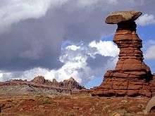
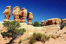
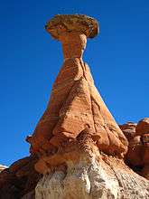
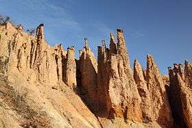
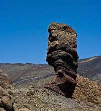
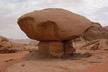
A hoodoo (also called a tent rock, fairy chimney, and earth pyramid) is a tall, thin spire of rock that protrudes from the bottom of an arid drainage basin or badland. Hoodoos, which may range from 1.5 to 45 metres (4.9 to 147.6 ft), typically consist of relatively soft rock topped by harder, less easily eroded stone that protects each column from the elements. They generally form within sedimentary rock and volcanic rock formations.
Hoodoos are found mainly in the desert in dry, hot areas. In common usage, the difference between hoodoos and pinnacles (or spires) is that hoodoos have a variable thickness often described as having a "totem pole-shaped body". A spire, on the other hand, has a smoother profile or uniform thickness that tapers from the ground upward. An example of a single spire, as an earth pyramid, is found at Aultderg Burn, near Fochabers, Scotland.
Hoodoos range in size from the height of an average human to heights exceeding a 10-story building. Hoodoo shapes are affected by the erosional patterns of alternating hard and softer rock layers. Minerals deposited within different rock types cause hoodoos to have different colors throughout their height.
Occurrence
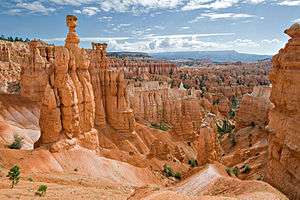
Hoodoos are commonly found in the High Plateaus region of the Colorado Plateau and in the Badlands regions of the Northern Great Plains (both in North America). While hoodoos are scattered throughout these areas, nowhere in the world are they as abundant as in the northern section of Bryce Canyon National Park, located in the U.S. state of Utah (see geology of the Bryce Canyon area). They are also very prominent a few hundred miles away at Goblin Valley State Park on the eastern side of the San Rafael Swell.
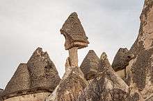
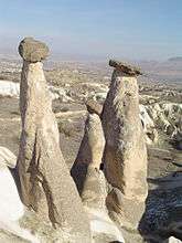
Hoodoos are a tourist attraction in the Cappadocia region of Turkey, where houses have been carved from these formations. These rock formations were depicted on the reverse of the Turkish 50 new lira banknote of 2005–2009.[1]
In French, they are called demoiselles coiffées ("ladies with hairdos") or cheminées de fées ("fairy chimneys") and a number of them are found in the Alpes-de-Haute-Provence; one of the best-known examples is the formation called Demoiselles Coiffées de Pontis.[2][3]
Đavolja Varoš (Devil's Town) hoodoos in Serbia feature 202 exotic formations described as earth pyramids or "towers", as the locals refer to them. Since 1959, Đavolja Varoš has been protected by the state. It was also a nominee in the New Seven Wonders of Nature campaign.[4]
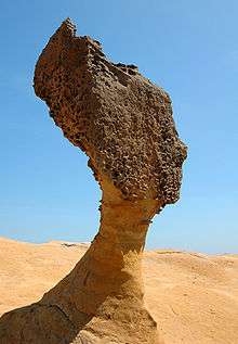
The hoodoo stones on the northern coast of Taiwan are unusual for their coastal setting. The stones formed as the seabed rose rapidly out of the ocean during the Miocene epoch.[5] Efforts have been made to slow the erosion in the case of iconic specimens in Wanli.
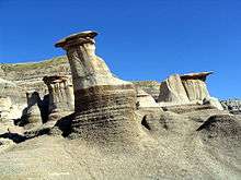
Hoodoos in Drumheller, Alberta, are a distinctive feature that continues to attract thousands of visitors each year. The sediments comprising these hoodoos formed between 70 and 75 million years ago during the Cretaceous Period as clay and sand sediments from the Horseshoe Canyon Formation were deposited. These hoodoos are able to maintain a unique mushroom-like appearance as the underlying base erodes at a faster rate compared to the capstones, a rate of nearly one centimeter per year, faster than most geologic structures.[6]
Formation
Hoodoos typically form in areas where a thick layer of a relatively soft rock, such as mudstone, poorly cemented sandstone or tuff (consolidated volcanic ash), is covered by a thin layer of hard rock, such as well-cemented sandstone, limestone or basalt. In glaciated mountainous valleys the soft eroded material may be glacial till with the protective capstones being large boulders in the till. Over time, cracks in the resistant layer allow the much softer rock beneath to be eroded and washed away. Hoodoos form where a small cap of the resistant layer remains, and protects a cone of the underlying softer layer from erosion. Further erosion of the soft layer causes the cap to be undercut, eventually falling off, and the remaining cone is then quickly eroded.[7][8]
Typically, hoodoos form from two weathering processes that continuously work together in eroding the edges of a rock formation known as a fin. The primary weathering force at Bryce Canyon (as one example) is frost wedging. The hoodoos at Bryce Canyon experience over 200 freeze/thaw cycles each year. In the winter, melting snow, in the form of water, seeps into the cracks and then freezes at night. When water freezes it expands by almost 10%, pries open the cracks bit by bit, making them even wider, much like the way a pothole forms in a paved road.
In addition to frost wedging, rain also sculpts these hoodoos. In most places today, the rainwater is slightly acidic, which lets the weak carbonic acid slowly dissolve limestone grain by grain. It is this process that rounds the edges of hoodoos and gives them their lumpy and bulging profiles. Where internal mudstone and siltstone layers interrupt the limestone, you can expect the rock to be more resistant to the chemical weathering because of the comparative lack of limestone. Many of the more durable hoodoos are capped with a special kind of magnesium-rich limestone called dolomite. Dolomite, being fortified by the mineral magnesium, dissolves at a much slower rate, and consequently protects the weaker limestone underneath it. Rain is also the chief source of erosion (the actual removal of the debris). In the summer, monsoon type rainstorms travel through the Bryce Canyon region bringing short duration high intensity rain.[9]
Gallery
 Hoodoos (earth pyramids) called Đavolja Varoš ("Devil's Town"), in Serbia
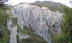
.jpg) Cheminée de fée, Puy-de-Dôme, France
Cheminée de fée, Puy-de-Dôme, France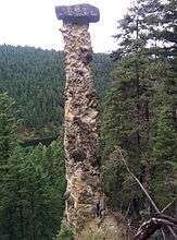
See also
- Balancing rock
- Mushroom rock
- Demoiselles Coiffées de Pontis, "ladies with hairdos" in the French Alps
- Cappadocia, Turkey, known for its fairy chimneys and buildings carved into the soft volcanic tuff
- Göreme National Park, Cappadocia, Turkey
- Kasha-Katuwe Tent Rocks National Monument in New Mexico
- Tea table, a flat-top, table-like hoodoo
- Chiricahua National Monument in southeastern Arizona
- City of Rocks State Park near Silver City, New Mexico
- Bisti/De-Na-Zin Wilderness near San Juan County, New Mexico
- Tsingy de Bemaraha Strict Nature Reserve
References
- ↑ Central Bank of the Republic of Turkey. "E8 - Fifty New Turkish Lira". Tcmb.gov.tr. Retrieved March 30, 2015.
- ↑ Haug, Émile (1907). Traité de géologie. 1. Librairie Armand Colin. p. 386.
- ↑ Godefroy, René (1940). La nature alpine: exposé de géographie physique. B. Arthaud. p. 121.
- ↑ "Djavolja Varos, Rock Formation". New 7 Wonders. Archived from the original on July 9, 2009. Retrieved March 31, 2015.
- ↑ Hong, Eason; Huang, Eugene (February 2001). "Formation of the pedestal rocks in the Taliao Formation, northern coast of Taiwan" (PDF). Western Pacific Earth Sciences. 1 (1): 99–106. Retrieved March 31, 2015.
- ↑ Royal Tyrrell Museum. "Hoodoos". Tyrrellmuseum.com. Retrieved March 30, 2015.
- ↑ Yilmaz, H.M.; Yakar, M.; Mutluoglu, O.; Kavurmaci, M.M.; Yurt, K. (2012). "Monitoring of soil erosion in Cappadocia region (Selime-Aksaray-Turkey)". Environmental Earth Sciences. Springer. 66 (1): 75–81. Retrieved 20 June 2012.
- ↑ Hopkins, R.L. (2003). "Coal Mine Canyon". Hiking the Southwest's Geology: Four Corners Region. The Mountaineers Books. pp. 107–108. ISBN 9780898868562.
- ↑ "Hoodoos". nps.gov. Retrieved 22 March 2015.
Further reading
- DeCourten, Frank. 1994. Shadows of Time, the Geology of Bryce Canyon National Park. Bryce Canyon Natural History Association.
- Kiver, Eugene P., Harris, David V. 1999. Geology of U.S. Parklands 5th ed. John Wiley & Sons, Inc. 522–528.
- Sprinkel, Douglas A., Chidsey, Thomas C. Jr., Anderson, Paul B. 2000. Geology of Utah's Parks and Monuments. Publishers Press: 37–59
External links
| Wikimedia Commons has media related to |
- National Park Service: Bryce Canyon National Park: Nature and Geology - Hoodoos (adapted public domain text)
- Hoodoos (Erdpyramiden - demoiselles coiffées) world-wide