Death Valley '49ers

The Death Valley '49ers were a group of pioneers from the Eastern United States that endured a long and difficult journey during the late 1840s California Gold Rush to prospect in the Sutter's Fort area of the Central Valley and Sierra Nevada in California. Their route from Utah went through the Great Basin Desert in Nevada, and Death Valley and the Mojave Desert in Southern California, in attempting to reach the Gold Country.
The Gold Rush
On January 24, 1848, James W. Marshall and his crew found gold at Sutter's Mill in Coloma, California. This discovery would lure tens of thousands of people from the United States and foreign nations. People packed their belongings and began to travel by covered wagon to what they hoped would be new and better life. Since the first great influx of these pioneers began in 1849, they are generally referred to as 49ers.[1]
The start
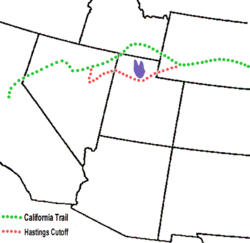
In the Fall of 1846, the Donner Party had pioneered the Hastings Cutoff of the California Trail through what would become, the next year, Salt Lake City. Blazing the new route had slowed the group, who reached the Sierra Nevada late in the fall. A storm trapped them in the mountains, a disastrous event.[2] The stories of the Donner Party were still fresh on everyone's mind when a group of wagons arrived at Salt Lake City in early fall, 1849. This was too late to reach the Sierra Nevada in time to cross the mountains without risk of similarly trapped, so it appeared the group would have to wait out the winter in Salt Lake City. They heard about the Old Spanish Trail, a route that went around the south end of the Sierras and was safe to travel in the winter. It was not certain if wagons could take the route, but some had recently headed for the trail to try, so the group found a guide by name of Jefferson Hunt who had previously traveled the route and agreed to lead them. These individuals would become part of a story of human suffering in a place which they named Death Valley.[1]
The first several days of travel from their gathering point near Provo, Utah went well at first. They traveled south along the present course of Interstate 15 to reach the Spanish Trail, which intersects I-15 at about present day Parowan, Utah but upon reaching the Beaver River about 30 miles north of Parowan, Hunt tried a route along which he had never personally traveled. He had previously traveled up the Spanish Trail from California with Porter Rockwell, and Rockwell had left the trail some miles west of where it intersected the I-15 corridor and taken a different route,[3] presumably cutting off several miles from the trip. The party traveled west down the Beaver River, to present day Minersville, Utah, where they camped for two nights to rest and prepare for a long stretch with no water. They then turned south and traveled twelves miles and made a dry camp, from which Hunt continued southwest across the Escalante Desert to find the Spanish Trail and locate a water source along it, to which he could lead the train directly from their present position. While the group waited for Hunt, they ended up driving their stock back to the river for water. Hunt ultimately could not find water, he almost died from thirst trying, and the party ended up turning back.[4] and continued down the I-15 corridor over the difficult Beaver Ridge to the Parowan Valley, where they camped near Little Salt Lake. The attempted shortcut had cost them seven days, which would strain their provisions for the rest of the trip.
The parties split up

The group's confidence in Hunt was diminished by the gaff at the Beaver River, and while in camp, a man by the name of Orson K. Smith rode in with a group taking a pack train and showed some of the people a map made by Elijah Barney Ward, a former trapper who had trailed stolen horses from California over Walker Pass.[5] The map showed a route from the Escalante Desert to the pass. After Smith and the pack train had left with the map, intending to take the trail themselves, discussion continued. Everyone agreed that the Ward route would cut off 500 miles from their journey so most of the 107 wagons decided to follow Smith. The party proceeded to the Spanish Trail and turned west, and when, at the end of October, they reached a point near present-day Enterprise, Utah, where the Jefferson Hunt Monument has been constructed to commemorate this historic event,[3] most of the wagons continued west while a handful turned south to follow the Spanish Trail with Hunt. Those that struck out on Ward route soon found themselves confronted with the precipitous obstacle of Beaver Dam Wash, a gaping canyon on the present-day Utah–Nevada state line (Beaver Dam State Park, Nevada). Smith and the pack train had been able to traverse the canyon, but the wagons could not.[5]
Most of the people became discouraged and turned back to join Jefferson Hunt, all but about 20 wagons decided to continue on. Despite the fact that the group didn't have a reliable map, they decided to continue on thinking that all they had to do was go west and they would eventually find the pass. It took several days to find a route around the wagons around the canyon, after which the group passed through the area of present-day Panaca, Nevada,[1] and crossed over "Bennetts Pass" to Del Mar Valley. Here they started having difficulty finding water but eventually found their way to Crystal Springs in the Pahranagat Valley. They continued over Hancock Summit into Tikaboo Valley and then on to Groom Lake, now encompassed by Area 51. At Groom Lake they got into a dispute on which way to go. One group—the Bennett-Arcan party—wanted to head south toward the distant, snow-clad Mt. Charleston in hopes of finding a good water source. The other group—the Jayhawkers—wanted to stay with the original plan of traveling west. The group eventually split and went their separate ways but they both were to have two things in common. They were both saved from dying of thirst by a snow storm and they both ended up meeting again[1] at Ash Meadows in the Amargosa Desert of the Amargosa Valley located east of Death Valley. From here they continued on, following the Amargosa River bed to present-day Death Valley Junction, California, and then along the same route followed by current California State Route 190 past the Funeral Mountains.[1]
Lost pioneers in Death Valley
On Christmas Eve of 1849, the group arrived at Travertine Springs in the west-facing canyon of the Amargosa Range, located about a mile from Furnace Creek Wash in Death Valley itself.[1]
The lost pioneers had now been traveling across the desert for about two months since leaving the Old Spanish Trail. Their oxen were weak from lack of forage and their wagons were in poor shape. They too were weary and discouraged but their worst problem was not the valley that lay before them. It was the towering Panamint Range mountains to the west that stood like an impenetrable wall as far as could be seen in both directions.
They decided to head toward what appeared to be a pass to the north near present-day Stovepipe Wells, but after discovering this was also impassable, decided they were going to have to leave their wagons and belongings behind and walk to civilization. They slaughtered several oxen and used the wood of their wagons to cook the meat and make jerky. The place where they did this is today referred to as "Burned Wagons Camp", present day Burnt Wagons, and is located near the sand dunes of Death Valley. From here, they began climbing toward Towne Pass and then turned south over Emigrant Pass to Wildrose Canyon in the Panamint Range.[1] After crossing the mountains and dropping down into Panamint Valley, they turned south and climbed a small pass into Searles Valley, with Searles Lake, before making their way into Indian Wells Valley near present-day Ridgecrest. It was here that they finally got their first look at the Sierra Nevada Mountains. They turned south, probably following a trail and traveled across Fremont Valley, close to the same route followed by current California State Route 14. Ironically, they walked right by Walker Pass, present-day California State Route 178 to Lake Isabella, the mountain pass they had set out to look for almost three months earlier. [1]
Passing by Walker Pass, they entered into what was to become the worst part of their journey, across the Mojave Desert and its Antelope Valley. This is a region with very few water sources to be found. The only things that saved them from dying of thirst were a few puddles of water and ice from a recent storm. Eventually they found their way over a pass in the Sierra Pelona Mountains near Palmdale, and, following the Santa Clara River, were finally discovered and rescued by Mexican Californios cowboys from Rancho Ex-Mission San Fernando, located near present-day Santa Clarita Valley.
See also
- Death Valley
- Death Valley National Park
- Geology of the Death Valley area
- Places of interest in the Death Valley area
- History of California through 1899
- William L. Manly
- John Haney Rogers
Citations
- 1 2 3 4 5 6 7 8 "The Lost '49ers". National Park Service. Retrieved May 22, 2016.
- ↑ Chalfant, p. 18
- 1 2 http://www.utahsdixie.info/hs/l03-hunt.html
- ↑ Lyman, Edward Leo (2004). The Overland Journey. Reno and Las Vegas: University of Nevada Press. p. 63. ISBN 0874177529.
- 1 2 Lingenfelter, Richard E. (1988). Death Valley and the Amargosa: A Land of Illusion. University of California Press,. p. 34.
References
- Chalfant, Willie Arthur (1953). Death Valley The Facts. Stanford University Press.
External links
- Death_Valley_49ers-org: Nonprofit group commemorating The Death Valley '49ers
- Death Valley in '49 by William Lewis Manly
- Map of the Gold Regions of California, Showing the Routes via Chagres and Panama, Cape Horn, &c.