Beaver River (Utah)
| Beaver River (Utah) | |
| Country | United States |
|---|---|
| State | Utah |
| Tributaries | |
| - left | South Fork Beaver River, South Creek (Beaver River) |
| - right | East Fork Beaver River, North Creek (Beaver River), Indian Creek (Beaver River), Cove Creek |
| Source | Confluence of South and East Forks |
| - location | Tushar Mountains, Beaver County |
| - elevation | 7,142 ft (2,177 m) |
| - coordinates | 38°16′57″N 112°26′50″W / 38.28250°N 112.44722°W [1] |
| Mouth | Sevier River |
| - location | near Delta, Millard County |
| - elevation | 4,557 ft (1,389 m) |
| - coordinates | 39°09′11″N 112°50′06″W / 39.15306°N 112.83500°WCoordinates: 39°09′11″N 112°50′06″W / 39.15306°N 112.83500°W [1] |
| Length | 110 mi (177 km) [2] |
| Basin | 2,466 sq mi (6,387 km2) [3] |
| Discharge | for Beaver |
| - average | 51.5 cu ft/s (1 m3/s) [4] |
| - max | 1,080 cu ft/s (31 m3/s) |
| - min | 7.2 cu ft/s (0 m3/s) |
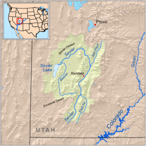 Map of the Sevier River system, including the Beaver River
| |
The Beaver River is a river in western Utah, 110 miles (180 km) long, that drains to Sevier Lake via the Sevier River.[2]
The river starts in the Tushar Mountains, in eastern Beaver County near the town of Beaver, and flows for about 30 miles (48 km) west as a perennial stream, through the Beaver Valley to the Escalante Desert, where it turns north. The river then continues north for about 80 miles (130 km) as an ephemeral wash, past Milford into Millard County. Once it reaches the Sevier Desert south of Delta it turns west, joining the Sevier River and emptying into the intermittent, endorheic Sevier Lake.[2][5]
The Beaver River watershed drains about 2,466 square miles (6,390 km2),[3] most of it desert. The human population is about 3500, mostly concentrated in the town of Beaver. The river is dammed for irrigation in its upper reaches by Rocky Ford Dam, forming Minersville Reservoir. A total of 84,000 acres (34,000 ha) are farmed in the basin.[6]
See also
References
- 1 2 "Beaver River". Geographic Names Information System. United States Geological Survey. 1979-12-31. Retrieved 2015-01-02.
- 1 2 3 Hahl, D.C.; Mundorff, J.C. (1968). "An Appraisal of the Quality of Surface Water in the Beaver River Basin, 1964" (PDF). State of Utah Department of Natural Resources, Technical Publication No. 19. Utah Division of Water Rights. Retrieved 2015-01-02.
- 1 2 "Boundary Descriptions and Names of Regions, Subregions, Accounting Units and Cataloging Units". United States Geological Survey. Retrieved 2015-01-02.
- ↑ "USGS Gage #10234500 on the Beaver River near Beaver, UT" (PDF). National Water Information System. United States Geological Survey. 1915–2013. Retrieved 2015-01-02.
- ↑ USGS Topo Maps for United States (Map). Cartography by United States Geological Survey. ACME Mapper. Retrieved 2015-01-02.
- ↑ "Beaver River Watershed" (PDF). Improving Utah’s Water Quality. Utah State University. November 2012. Retrieved 2015-01-02.