County of St. Paul No. 19
| County of St. Paul No. 19 | |
|---|---|
| Municipal district | |
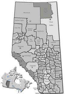 Location of St. Paul County No. 19 in Alberta | |
| Coordinates: 53°59′34″N 111°17′50″W / 53.99278°N 111.29722°WCoordinates: 53°59′34″N 111°17′50″W / 53.99278°N 111.29722°W | |
| Country |
|
| Province |
|
| Region | Northern Alberta |
| Census division | No. 12 |
| Established | 1942 |
| Incorporated | 1962 (County) |
| Government[1] | |
| • Reeve | Steve Upham |
| • Governing body | County of St. Paul Council |
| • Office location | St. Paul |
| Area (2011)[2] | |
| • Total | 3,296.72 km2 (1,272.87 sq mi) |
| Population (2011)[2] | |
| • Total | 5,831 |
| • Density | 1.8/km2 (4.6/sq mi) |
| • Dwellings | 2,617 |
| Time zone | MST (UTC-7) |
| Website |
county |
The County of St. Paul No. 19 is a municipal district in northeast Alberta, Canada. Located in Census Division No. 12, its municipal office is located in the Town of St. Paul.[3]
History
It was previously known as the Municipal District of St. Paul No. 86 until January 1, 1962 when it became the County of St. Paul No. 19.
Demographics
The County of St. Paul No. 19's 2012 municipal census counted a population of 6,168.[4]
In the 2011 Census, the County of St. Paul No. 19 had a population of 5,831 living in 2,207 of its 2,608 total dwellings, a -1.6% change from its 2006 population of 5,925. With a land area of 3,296.72 km2 (1,272.87 sq mi), it had a population density of 1.8/km2 (4.6/sq mi) in 2011.[2] Following St. Paul’s 2011 annexation, Statistics Canada adjusted the County of St. Paul No. 19's 2011 population downward by 5 people to 5,826.[5]
In 2006, the County of St. Paul No. 19 had a population of 5,925 living in 2,617 dwellings, a 3.5% decrease from 2001. The county has a land area of 3,297.74 km2 (1,273.26 sq mi) and a population density of 1.8/km2 (4.7/sq mi).[6]
In 2001, the county had a population of 6,145 in 3,255 dwellings, a 2.7% decrease from 1996. On a surface of 3,297.21 km² it had a density of 1.9 inhabitants/km².[7]
Communities and localities
|
The following urban municipalities are surrounded by the County of St. Paul No. 19:[8]
The following hamlets are located within the County of St. Paul No. 19:[8] |
The following localities are located within the County of St. Paul No. 19:[9]
|
|
See also
References
- ↑ Alberta Municipal Affairs: Municipal Officials Search
- 1 2 3 "Population and dwelling counts, for Canada, provinces and territories, and census subdivisions (municipalities), 2011 and 2006 censuses (Alberta)". Statistics Canada. 2012-02-08. Retrieved 2012-02-08.
- ↑ "County of St. Paul No. 19 - Location and History Profile". Alberta Municipal Affairs. 2011-05-13. Retrieved 2011-05-17.
- ↑ "County of St. Paul No. 19, July 17, 2012 Agenda". County of St. Paul No. 19. 2012-07-10. p. 125-126 of 180. Retrieved 2012-07-15.
- ↑ "Interim List of Changes to Municipal Boundaries, Status, and Names From January 2, 2011 to January 1, 2012 (Table 1 – Changes to census subdivisions in alphabetical order by province and territory)" (XLSX). Statistics Canada. November 14, 2012. Retrieved August 17, 2013.
- ↑ "Canada 2006 Census: County of St. Paul No. 19 - Community Profile". Statistics Canada. Retrieved 2007-06-11.
- ↑ County of St. Paul community profile - Statistics Canada. 2002. 2001 Community Profiles. Released June 27, 2002. Last modified: 2005-11-30. Statistics Canada Catalogue no. 93F0053XIE.
- 1 2 "Specialized and Rural Municipalities and Their Communities" (PDF). Alberta Municipal Affairs. 2012-03-01. Retrieved 2012-08-12.
- ↑ "Standard Geographical Classification (SGC) 2006, Economic Regions: 4812014 - St. Paul County No. 19, geographical codes and localities, 2006". Statistics Canada. 2010-03-05. Retrieved 2012-08-12.
External links

| Subdivisions | |||||||||||
|---|---|---|---|---|---|---|---|---|---|---|---|
| Communities | |||||||||||
| Cities and urban service areas | |||||||||||
| Rural municipalities |
| ||||||||||
| Specialized municipalities | |||||||||||
| |||||||||||