Camrose, Alberta
| Camrose | |
|---|---|
| City | |
| City of Camrose | |
|
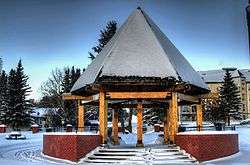
Mirror Lake Park in Camrose | |
|
| |
|
Nickname(s): The Rose City[1] Slogan: The stage is set[2] | |
 Camrose Location of Camrose in Alberta | |
| Coordinates: 53°1′N 112°50′W / 53.017°N 112.833°WCoordinates: 53°1′N 112°50′W / 53.017°N 112.833°W | |
| Country | Canada |
| Province | Alberta |
| Region | Central Alberta |
| Census division | 10 |
| Municipal district | Camrose County |
| Incorporated[3] | |
| • Village | May 4, 1905 |
| • Town | December 11, 1906 |
| • City | January 1, 1955 |
| Government[4][5][6][7] | |
| • Mayor | Norm Mayer[4] |
| • Governing body |
Camrose City Council
|
| • City Manager[5] | Malcolm Boyd |
| • MP | Kevin Sorenson (Cons[6] – Battle River—Crowfoot) |
| • MLA | Bruce Hinkley (New Democratic Party[7] – Wetaskiwin-Camrose) |
| Area (2011)[8] | |
| • Total | 42.50 km2 (16.41 sq mi) |
| Elevation[9] | 740 m (2,430 ft) |
| Population (2011)[8] | |
| • Total | 17,286 |
| • Density | 406.7/km2 (1,053/sq mi) |
| • Municipal census (2016) | 18,044[10] |
| Time zone | Mountain (UTC−7) |
| • Summer (DST) | MDT (UTC−6) |
| Area code(s) | 780, 587, 825 |
| NTS Map | 083H02 |
| GNBC Code | IAKKF |
| Highways | 13, 26, 833 |
| Website | City of Camrose |
Camrose /ˈkæmroʊz/ is a city in central Alberta, Canada, amid some of the richest farmland in the prairies. It is a relatively small city which originally grew up along a railroad and now grows along Highway 13.
History
The area around Camrose was first settled in around 1900. At that time the nearby settlement of Wetaskiwin was a major centre for pioneers; typically, it was the last stopping-off point before they set out in search of nearby land. The site that was to be Camrose was about a day's journey from Wetaskiwin along the railroad, which made it a popular place on the route of pioneers. Soon businessmen and other settlers arrived to stay. The settlers came primarily from Scandinavian countries, such as Norway and Sweden, and many settlers also came from the United States. At that time the settlement was known as the hamlet of Stoney Creek. In 1904, Stoney Creek began receiving mail service, its first businesses began to open, and its first RCMP officer (Constable "Blue" Smith) arrived.
On May 4, 1905, the settlement was incorporated as the Village of Sparling, named for Reverend Dr. Sparling of Winnipeg.[11] However, because the name was often confused with Sperling and Stirling, in 1906 the Village Council renamed the settlement to Camrose.[12] There is no factual evidence about the reason for the choice of the name Camrose, but it is generally thought that it was named after the Village of Camrose in Pembrokeshire, South Wales. In December 1906, Camrose was incorporated as a town.
In 1906, Camrose opened its first newspaper, The Camrose Mail, which was replaced in 1908 by the Camrose Canadian,[13] which is still published to this day. In March 1907 the town erected a building for town administration, which also held its first police and fire station. In May 1907, it spent $10,000 on its schoolhouse.[14] In October 1907 men from Alberta Government Telephones set up Camrose's first telephone exchange, and by 1908 about fifty residents had telephone access. 1911 saw the construction of Camrose's first power plant.
From 1905 to 1914, there was a great deal of railway construction in the Camrose area. Camrose became a bit of a railroad hub, sitting on railways that connected to Edmonton and Calgary, as well as many of the smaller towns in central Alberta, such as Vegreville, Stettler, Drumheller, and Wetaskiwin. By 1914, twelve passenger trains came through Camrose daily. In those days the growth of Camrose was strongly linked with the railway.
On June 26, 1912, the first building of the Camrose Lutheran College (known as Augustana University College from 1991 to 2004) was opened. Today the campus continues as the Augustana Faculty of the University of Alberta.
During World War II, the Camrose Fairgrounds were converted to an army training grounds. About ten H-Shaped huts were built, as well as mess quarters, a medical building and a storehouse. Thousands of Canadian boys came to Camrose to receive their basic training.
Camrose became a city on January 1, 1955. By 1958, Camrose had converted the old post office into the new City Hall. In 1954, however, Camrose had sold the old town hall to the federal government, so in the interim the city council met for almost three years in the hall of the local Methodist Church.
Camrose has continued to expand, even as the significance of the railroads waned. It is now stretching out along Highway 13, and is becoming a major stop for travellers along that road. With the advent of the Big Valley Jamboree [15] in Camrose it has become even more oriented towards tourism and hospitality.[16]
Camrose was host to a popular Alberta Music Camp for upwards of 40 years, named MusiCamrose, until it later changed to MusiCamp Alberta, now hosted in Red Deer, Alberta. It celebrated its 50th anniversary in the summer of 2007. It was founded by Peterkin.
On Wednesday, October 26, 2005, a single lottery ticket worth $54,000,000 (the second largest in Canadian history) was sold in Camrose. The ticket belonged to 17 oil industry workers.
In August 2006, Camrose held a Founders Day when four men were inducted as founding fathers of Camrose.
Geography
Camrose is situated about 90 kilometres (56 mi) from Edmonton, the capital of Alberta. Camrose is a small city, but is actively growing along Highway 13, which runs through its centre. Camrose is located in a transitory region of Alberta, between prairie and boreal forest, known as aspen parkland. It is a major economic centre for many small farming communities in the surrounding area. The Stoney Creek runs through the city and flows into the Battle River south of the city.
Climate
Camrose has a humid continental climate (Köppen climate classification Dfb)[17] and falls into the NRC Plant Hardiness Zone 3b.[18]
| Climate data for Camrose (1981−2010 normals) | |||||||||||||
|---|---|---|---|---|---|---|---|---|---|---|---|---|---|
| Month | Jan | Feb | Mar | Apr | May | Jun | Jul | Aug | Sep | Oct | Nov | Dec | Year |
| Record high humidex | 11.0 | 11.6 | 24.5 | 25.4 | 31.6 | 37.2 | 39.7 | 38.5 | 33.3 | 26.6 | 17.3 | 13.4 | 39.7 |
| Record high °C (°F) | 11.1 (52) |
13.5 (56.3) |
25.1 (77.2) |
31.1 (88) |
32.5 (90.5) |
34.2 (93.6) |
36.7 (98.1) |
34.4 (93.9) |
33.0 (91.4) |
28.0 (82.4) |
21.1 (70) |
13.9 (57) |
36.7 (98.1) |
| Average high °C (°F) | −5.8 (21.6) |
−3.5 (25.7) |
1.5 (34.7) |
10.7 (51.3) |
17.0 (62.6) |
20.4 (68.7) |
22.9 (73.2) |
22.3 (72.1) |
16.7 (62.1) |
10.2 (50.4) |
−0.3 (31.5) |
−4.5 (23.9) |
9.0 (48.2) |
| Daily mean °C (°F) | −11.5 (11.3) |
−9.6 (14.7) |
−4.1 (24.6) |
4.5 (40.1) |
10.5 (50.9) |
14.5 (58.1) |
16.8 (62.2) |
15.8 (60.4) |
10.4 (50.7) |
4.1 (39.4) |
−5.2 (22.6) |
−9.9 (14.2) |
3.0 (37.4) |
| Average low °C (°F) | −17.2 (1) |
−15.7 (3.7) |
−9.7 (14.5) |
−1.7 (28.9) |
4.0 (39.2) |
8.5 (47.3) |
10.7 (51.3) |
9.3 (48.7) |
4.0 (39.2) |
−2.0 (28.4) |
−10.0 (14) |
−15.3 (4.5) |
−2.9 (26.8) |
| Record low °C (°F) | −47.2 (−53) |
−47.8 (−54) |
−42.8 (−45) |
−32.2 (−26) |
−11.7 (10.9) |
−1.1 (30) |
1.0 (33.8) |
−1.1 (30) |
−16.1 (3) |
−23.0 (−9.4) |
−35.7 (−32.3) |
−44.0 (−47.2) |
−47.8 (−54) |
| Record low wind chill | −54.0 | −52.0 | −47.0 | −29.0 | −15.0 | −3.0 | 0.0 | 0.0 | −12.0 | −26.0 | −44.0 | −50.0 | −54.0 |
| Average precipitation mm (inches) | 22.8 (0.898) |
13.5 (0.531) |
22.5 (0.886) |
28.9 (1.138) |
41.2 (1.622) |
74.4 (2.929) |
85.8 (3.378) |
51.5 (2.028) |
39.9 (1.571) |
23.5 (0.925) |
18.5 (0.728) |
15.4 (0.606) |
438.1 (17.248) |
| Average rainfall mm (inches) | 0.8 (0.031) |
0.3 (0.012) |
1.4 (0.055) |
18.4 (0.724) |
38.0 (1.496) |
74.4 (2.929) |
85.8 (3.378) |
51.5 (2.028) |
39.6 (1.559) |
13.2 (0.52) |
2.0 (0.079) |
0.9 (0.035) |
326.3 (12.846) |
| Average snowfall cm (inches) | 21.6 (8.5) |
13.4 (5.28) |
21.7 (8.54) |
10.5 (4.13) |
3.2 (1.26) |
0.0 (0) |
0.0 (0) |
0.0 (0) |
0.2 (0.08) |
10.5 (4.13) |
16.8 (6.61) |
15.6 (6.14) |
113.5 (44.69) |
| Source: Environment Canada,[19] | |||||||||||||
Demographics
| Federal census population history | ||
|---|---|---|
| Year | Pop. | ±% |
| 1906 | 412 | — |
| 1911 | 1,586 | +285.0% |
| 1916 | 1,692 | +6.7% |
| 1921 | 1,892 | +11.8% |
| 1926 | 2,002 | +5.8% |
| 1931 | 2,258 | +12.8% |
| 1936 | 2,263 | +0.2% |
| 1941 | 2,598 | +14.8% |
| 1946 | 2,967 | +14.2% |
| 1951 | 4,131 | +39.2% |
| 1956 | 5,817 | +40.8% |
| 1961 | 6,939 | +19.3% |
| 1966 | 8,362 | +20.5% |
| 1971 | 8,673 | +3.7% |
| 1976 | 10,104 | +16.5% |
| 1981 | 12,570 | +24.4% |
| 1986 | 12,968 | +3.2% |
| 1991 | 13,420 | +3.5% |
| 1996 | 13,728 | +2.3% |
| 2001 | 14,854 | +8.2% |
| 2006 | 15,620 | +5.2% |
| 2011 | 17,286 | +10.7% |
| Source: Statistics Canada [20][21][22][23][24][25][26][27][28][29][30] [8][31][32][33][34][35][36][37][38][39][40] | ||
The population of the City of Camrose according to its 2016 municipal census is 18,044,[10] a 0.03% change from its 2014 municipal census population of 18,038.[41]
In the 2011 Census, the City of Camrose had a population of 17,286 living in 7,460 of its 7,945 total dwellings, a 10.6% change from its 2006 adjusted population of 15,630. With a land area of 42.5 km2 (16.4 sq mi), it had a population density of 406.7/km2 (1,053.4/sq mi) in 2011.[8]
According to the Canada 2006 Census [42]
| * Population: | 15,620 (5.0% increase from 2001) |
| * Land area: | 31.14 km2 (12.02 sq mi) |
| * Population density: | 501.6 people/km² (1,299.1/sq mi) |
| * Median age: | 41.8 (males: 39.7, females: 43.6) |
| * Total private dwellings: | 6,962 |
| * Mean household income: | $47,972 |
The primary ancestries are Scandinavian (26.3%), German (25.6%), English (20.2%), Scottish (17.6%), Irish (14.4%), and Aboriginal (3.5%).[43]
English is the first language of 90% of the population. About 2.1% of residents said German, 1.1% said Ukrainian, 1.0% said French, and 0.7% said Spanish was their first language. The next most common languages were Chinese and Dutch at 0.6% each, followed by Danish and Norwegian at 0.4% each, Swedish at 0.3%, and Lao at 0.2%.[44]
The 2001 census found 85% of residents identified as Christian, while 14% had no religious affiliation. For specific denominations Statistics Canada found that 24% of residents identified as Roman Catholic, while 20% identified as Lutheran, and 19% identified with the United Church of Canada. Among the less numerous denominations, 4% identified as Anglican, and about 2% each identified as Baptist and Pentecostal.[45]
Sports and recreation
The Camrose Recreation Centre, a multi-purpose sporting facility, officially opened on September 28, 2007. The complex includes the 2,500 seat Encana Arena (home of the Camrose Kodiaks of the AJHL and the Augustana Vikings of the ACAC), and the 300+ seat Border Paving arena. The facility also boasts a three lane fitness track, fitness centre, physiotherapy clinic, physiotherapy lab, children's play room, meeting rooms, offices, and food and beverage facilities. Attached to this facility is the Max McLean Arena (former home of the Viking Cup, the Vikings and the Kodiaks), as well as the Camrose Aquatic Centre and curling rink.
Other recreational facilities include the Camrose Community Centre (walking track and indoor soccer centre), spray park, Camrose Skate Park, Kinsmen Park (which includes tennis courts, three fastball fields, football field, beach volleyball courts, a 2.2 km walking path), and Rudy Swanson Park, home to various soccer facilities and recreational groups.
Camrose has a large urban trail system which winds through Stoney Creek Valley. The total trail length is approximately 10.2 km.
Camrose is also home to a wide variety of sports clubs including figure skating, baseball, fastball, hockey and swimming to name a few. The Camrose Ski Club, founded in 1911, is the oldest cross-country ski club in Canada, and has produced many elite level athletes including several Olympians.
Parks
Camrose is known colloquially as the "Rose City" due to the large number of wild roses which grow in the surrounding parklands. Developed to withstand the drastic Alberta climate, the Camrose Rose was introduced to the city in 1995. Local rose grower Jerry Twomey bred and patented this beautiful rose to honour his birthplace. An elegant tea rose, the variety boasts abundant pink blooms and rich green foliage, making it the most stunning flower in our rose beds. It may be seen on display at the Bill Fowler Centre.
- Jubilee Park is often used by the community, located in a valley and featuring barbecue shelters, a wandering stream and wide open space.
- Mirror Lake sits in the centre of the city. Once a reservoir for the electrical plants which powered the city, the man-made lake is now home to two species of swan: the trumpeter and the Polish mute. The City of Camrose provides a winter shelter to the clipped birds. These swans have called Camrose home for over twenty years. Mirror Lake Park is the focal point of the Camrose urban parks system. Located on the edge of Mirror Lake, it is the home of the Bill Fowler Centre which contains the Chamber of Commerce office and the Tourist Information Centre. The Bill Fowler Centre features a nature mural, carved out of red brick. The mural features many of the animals which are indigenous to the Mirror Lake area.
- Mirror Lake flows from Stoney Creek, which wanders through the city, and provides a river valley for viewing wildlife through paved walking paths.
Government
The current mayor in Camrose is Norman Mayer,[4] and Malcolm Boyd is the city's manager.[5] The Camrose City Council is made up of six elected people Agnes Hovelan, Kevin Hycha, Max Lindstrand James Sears, PJ Stasko, Wayne Throndson.[4] The current MP is Kevin Sorenson,[6] and the current MLA is Bruce Hinkley.[7]
Infrastructure
Camrose is served by Camrose Airport.
Camrose's water supply comes from nearby Driedmeat Lake.[46]
Education
Secondary
Two authorities provide secondary schooling in Camrose, including the Battle River School Division (BRSD) and Elk Island Catholic Schools (EICS). The BRSC operates 37 schools in Camrose and the surrounding area. EICS operates one elementary school (St. Patrick Catholic School) and one junior/senior high-school (Our Lady of Mount Pleasant Catholic School).
Post-secondary
The primary post-secondary institution in Camrose is the Augustana Faculty of the University of Alberta (formerly known as Augustana University College). Established in 1910 by Norwegian settlers, under the name Camrose Lutheran College. As a Faculty of the University of Alberta, Augustana continues to build on its reputation for high-quality teaching in a friendly, caring, residence-based setting. In doing so, it provides a distinctive small-campus undergraduate experience within one of Canada's leading universities. Augustana remains mindful of its heritage, open to a diversity of perspectives and backgrounds, and responsive to the rural region in which it is located.
In 2006, the university celebrated its first fourth generation graduate.
Camrose also hosts the Canadian Lutheran Bible Institute [47] and Gardner College (previously known as Gardner Bible College and Alberta Bible Institute).[48]
Media
Camrose is served by three local papers. The weekly Camrose Canadian, the weekly Camrose Booster and the small daily, Camrose Morning News. There is also a local Christian paper published monthly called "Crosswalk".
Camrose has its own local television station which is primarily used for advertising.
Camrose is also home to two radio stations. The first, and most famous, is AM station 840 CFCW. Despite having a studio in West Edmonton Mall, CFCW still has its main broadcast studio in Camrose.
The second station is the much-newer FM station, CAM-FM, at a frequency of 98.1 FM. Both stations are owned by Newcap Broadcasting.
Sister cities
The City of Camrose has twinning agreements with several similar communities in Canada and around the world. These relationships are developed in part with a mind toward promoting goodwill, education, economic and tourist benefits.
-
 Kamifurano, Hokkaido, Japan – 1984[49]
 -
 Warwick, Queensland, Australia – 1974
 -
 Saguenay, Quebec (formerly Chicoutimi) – 1978
 -
 Kentville, Nova Scotia – 1980
Notable people
- Tyler Bouck, professional hockey player currently with the ERC Ingolstadt of the Deutsche Eishockey Liga
- Scott Ferguson, retired professional hockey player
- Josh Green, retired professional hockey player
- Kenneth E. Iverson (1920–2004), creator of the APL programming language and winner of the Turing Award in 1979
References
- ↑ "Hockey Day here". Camrose Canadian. Sun Media Corporation. January 8, 2007. Retrieved September 12, 2015.
- ↑ "Councillors look at new marketing campaign". Camrose Canadian. Sun Media Corporation. May 8, 2014. Retrieved September 12, 2015.
- ↑ "Location and History Profile: City of Camrose" (PDF). Alberta Municipal Affairs. June 17, 2016. p. 22. Retrieved June 18, 2016.
- 1 2 3 4 5 "Mayor and Council". Camrose. Government of Camrose. Retrieved 26 March 2016.
- 1 2 3 "Malcolm Boyd". Camrose. Government of Camrose. Retrieved 26 March 2016.
- 1 2 3 "SORENSON, The Hon. Kevin, P.C.". Parliament of Canada. Government of Canada. Retrieved 26 March 2016.
- 1 2 3 "Mr. Bruce Hinkley (ND)". Legislative Assembly. Government of Alberta. Retrieved 26 March 2016.
- 1 2 3 4 "Population and dwelling counts, for Canada, provinces and territories, and census subdivisions (municipalities), 2011 and 2006 censuses". Statistics Canada. 2012-02-08. Retrieved 2012-02-08.
- ↑ "Alberta Private Sewage Systems 2009 Standard of Practice Handbook: Appendix A.3 Alberta Design Data (A.3.A. Alberta Climate Design Data by Town)" (PDF) (PDF). Safety Codes Council. January 2012. pp. 212–215 (PDF pages 226–229). Retrieved October 8, 2013.
- 1 2 "City of Camrose Census 2016 Information & Results". City of Camrose. Retrieved October 8, 2016.
- ↑ Camrose Historical Society (1947). Early history of Camrose, Alberta and district. p. 3.
- ↑ CPG Camrose – Camrose History
- ↑ The Camrose Canadian,
- ↑ Camrose Board of Trade (1907). Camrose : the rose of Alberta.
- ↑ Big Valley Jamboree – Country Music Festival
- ↑ Tourism Camrose – Nature Tourism
- ↑ "Climate Regions" (Image (JPE) FTP). FTP Home - Natural Resources Canada Archives. Natural Resources Canada (Archives). Retrieved 26 March 2016.
- ↑ "Plant Hardiness Zone by Municipality". Natural Resources Canada. Government of Canada. Retrieved 26 March 2016.
- ↑ "Camrose". Canadian Climate Normals 1981−2010. Environment Canada. April 19, 2016. Retrieved June 7, 2016.
- ↑ "Table IX: Population of cities, towns and incorporated villages in 1906 and 1901 as classed in 1906". Census of the Northwest Provinces, 1906. Sessional Paper No. 17a. Ottawa: Government of Canada. 1907. p. 100.
- ↑ "Table I: Area and Population of Canada by Provinces, Districts and Subdistricts in 1911 and Population in 1901". Census of Canada, 1911. Volume I. Ottawa: Government of Canada. 1912. pp. 2–39.
- ↑ "Table I: Population of Manitoba, Saskatchewan, and Alberta by Districts, Townships, Cities, Towns, and Incorporated Villages in 1916, 1911, 1906, and 1901". Census of Prairie Provinces, 1916. Population and Agriculture. Ottawa: Government of Canada. 1918. pp. 77–140.
- ↑ "Table 8: Population by districts and sub-districts according to the Redistribution Act of 1914 and the amending act of 1915, compared for the census years 1921, 1911 and 1901". Census of Canada, 1921. Ottawa: Government of Canada. 1922. pp. 169–215.
- ↑ "Table 7: Population of cities, towns and villages for the province of Alberta in census years 1901–26, as classed in 1926". Census of Prairie Provinces, 1926. Census of Alberta, 1926. Ottawa: Government of Canada. 1927. pp. 565–567.
- ↑ "Table 12: Population of Canada by provinces, counties or census divisions and subdivisions, 1871–1931". Census of Canada, 1931. Ottawa: Government of Canada. 1932. pp. 98–102.
- ↑ "Table 4: Population in incorporated cities, towns and villages, 1901–1936". Census of the Prairie Provinces, 1936. Volume I: Population and Agriculture. Ottawa: Dominion Bureau of Statistics. 1938. pp. 833–836.
- ↑ "Table 10: Population by census subdivisions, 1871–1941". Eighth Census of Canada, 1941. Volume II: Population by Local Subdivisions. Ottawa: Dominion Bureau of Statistics. 1944. pp. 134–141.
- ↑ "Table 6: Population by census subdivisions, 1926–1946". Census of the Prairie Provinces, 1946. Volume I: Population. Ottawa: Dominion Bureau of Statistics. 1949. pp. 401–414.
- ↑ "Table 6: Population by census subdivisions, 1871–1951". Ninth Census of Canada, 1951. Volume I: Population, General Characteristics. Ottawa: Dominion Bureau of Statistics. 1953. p. 6.73–6.83.
- ↑ "Table 6: Population by sex, for census subdivisions, 1956 and 1951". Census of Canada, 1956. Population, Counties and Subdivisions. Ottawa: Dominion Bureau of Statistics. 1957. p. 6.50–6.53.
- ↑ "Table 6: Population by census subdivisions, 1901–1961". 1961 Census of Canada. Series 1.1: Historical, 1901–1961. Volume I: Population. Ottawa: Dominion Bureau of Statistics. 1963. p. 6.77–6.83.
- ↑ "Population by specified age groups and sex, for census subdivisions, 1966". Census of Canada, 1966. Population, Specified Age Groups and Sex for Counties and Census Subdivisions, 1966. Ottawa: Dominion Bureau of Statistics. 1968. p. 6.50–6.53.
- ↑ "Table 2: Population of Census Subdivisions, 1921–1971". 1971 Census of Canada. Volume I: Population, Census Subdivisions (Historical). Ottawa: Statistics Canada. 1973. p. 2.102–2.111.
- ↑ "Table 3: Population for census divisions and subdivisions, 1971 and 1976". 1976 Census of Canada. Census Divisions and Subdivisions, Western Provinces and the Territories. Volume I: Population, Geographic Distributions. Ottawa: Statistics Canada. 1977. p. 3.40–3.43.
- ↑ "Table 4: Population and Total Occupied Dwellings, for Census Divisions and Subdivisions, 1976 and 1981". 1981 Census of Canada. Volume II: Provincial series, Population, Geographic distributions (Alberta). Ottawa: Statistics Canada. 1982. p. 4.1–4.10. ISBN 0-660-51095-2.
- ↑ "Table 2: Census Divisions and Subdivisions – Population and Occupied Private Dwellings, 1981 and 1986". Census Canada 1986. Population and Dwelling Counts – Provinces and Territories (Alberta). Ottawa: Statistics Canada. 1987. p. 2.1–2.10. ISBN 0-660-53463-0.
- ↑ "Table 2: Population and Dwelling Counts, for Census Divisions and Census Subdivisions, 1986 and 1991 – 100% Data". 91 Census. Population and Dwelling Counts – Census Divisions and Census Subdivisions. Ottawa: Statistics Canada. 1992. pp. 100–108. ISBN 0-660-57115-3.
- ↑ "Table 10: Population and Dwelling Counts, for Census Divisions, Census Subdivisions (Municipalities) and Designated Places, 1991 and 1996 Censuses – 100% Data". 96 Census. A National Overview – Population and Dwelling Counts. Ottawa: Statistics Canada. 1997. pp. 136–146. ISBN 0-660-59283-5.
- ↑ "Population and Dwelling Counts, for Canada, Provinces and Territories, and Census Divisions, 2001 and 1996 Censuses – 100% Data (Alberta)". Statistics Canada. Retrieved 2012-04-02.
- ↑ "Population and dwelling counts, for Canada, provinces and territories, and census subdivisions (municipalities), 2006 and 2001 censuses – 100% data (Alberta)". Statistics Canada. 2010-01-06. Retrieved 2012-04-02.
- ↑ "Census 2014" (PDF). City of Camrose. p. 2. Retrieved August 6, 2014.
- ↑ Statistics Canada. "Canada 2006 Census: Camrose – Community Profile". Retrieved 2007-06-13.
- ↑ "Camrose". Aboriginal Identity (8), Sex (3) and Age Groups (12) for the Population of Canada, Provinces, Territories, Census Metropolitan Areas and Census Agglomerations, 2006 Census – 20% Sample Data. Statistics Canada. 2008-01-15. Retrieved 2008-02-06.
- ↑ "Camrose". Detailed Mother Tongue (186), Knowledge of Official Languages (5), Age Groups (17A) and Sex (3) for the Population of Canada, Provinces, Territories, Census Metropolitan Areas and Census Agglomerations, 2001 and 2006 Censuses – 20% Sample Data. Statistics Canada. 2007-11-20. Retrieved 2008-02-06.
- ↑ "Camrose". Religion (95A), Age Groups (7A) and Sex (3) for Population, for Canada, Provinces, Territories, Census Metropolitan Areas and Census Agglomerations, 1991 and 2001 Censuses – 20% Sample Data. Statistics Canada. 2007-03-01. Retrieved 2008-02-06.
- ↑ Allen, J.A (1942). "Camrose Water Supply" (PDF). Alberta Geological Survey. Government of Alberta. Retrieved October 8, 2015.
- ↑ "Canadian Lutheran Bible Institute".
- ↑ "小顔骨格矯正極意".
- ↑ "Kamifurano Japan". City of Camrose. Government of Camroes. Retrieved 26 March 2016.
External links
![]() Media related to Camrose, Alberta at Wikimedia Commons
Media related to Camrose, Alberta at Wikimedia Commons
 |
Hay Lakes | Tofield | Ryley | |
| Wetaskiwin | |
Viking | ||
| ||||
| | ||||
| New Norway | Edberg | Bawlf |
| Subdivisions | |
|---|---|
| Communities | |
| Cities and urban service areas | |
| |