Brazeau County
| Brazeau County | ||
|---|---|---|
| Municipal district | ||
| ||
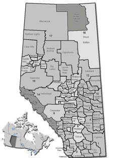 Location of Brazeau County in Alberta | ||
| Coordinates: 53°13′20″N 114°58′37″W / 53.22222°N 114.97694°WCoordinates: 53°13′20″N 114°58′37″W / 53.22222°N 114.97694°W | ||
| Country |
| |
| Province |
| |
| Region | Central Alberta | |
| Census division | No. 11 | |
| Improvement district | December 31, 1987[1] | |
| Municipal district | July 1, 1988[1] | |
| Name change | October 1, 2002[1] | |
| Government[2] | ||
| • Reeve | Bart Guyon | |
| • Governing body | Brazeau County Council | |
| • Office location | north of Drayton Valley | |
| Area (2011)[3] | ||
| • Total | 3,020.71 km2 (1,166.30 sq mi) | |
| Population (2011)[3] | ||
| • Total | 7,201 | |
| • Density | 2.4/km2 (6/sq mi) | |
| • Dwellings | 2,774 | |
| Time zone | MST (UTC-7) | |
| Website |
brazeau | |

Brazeau County is a municipal district in central Alberta, Canada. It is located in Census Division 11. The municipal district was incorporated on July 1, 1988 from Improvement District No. 222. On October 1, 2002, the name was changed from Municipal District of Brazeau No. 77 to Brazeau County.[1]
It is named for the Brazeau River, in turn named for Joseph Brazeau, a linguist associated with the Palliser Expedition.[4]
History
Brazeau County encompasses an area that was originally under the jurisdiction of three neighbouring municipalities.[5] In the mid-1980s, residents of the southwest portion of Parkland County and the west portion of Leduc County were growing weary of perceived poor service provision as a result of being located significant distances from their municipal headquarters in Stony Plain and Leduc respectively.[5] After much lobbying and petitions over approximately five years, lands were severed from Parkland County and Leduc County, as well as a small portion of Yellowhead County to the west,[5] to create Improvement District No. 222 on December 31, 1987, which incorporated as the Municipal District of Brazeau No. 77 six months later on July 1, 1988.[1] The municipality subsequently changed its name to Brazeau County on October 1, 2002.[1]
Demographics
In the 2011 Census, Brazeau County had a population of 7,201 living in 2,693 of its 2,852 total dwellings, a 2.3% change from its 2006 population of 7,040. With a land area of 3,020.71 km2 (1,166.30 sq mi), it had a population density of 2.4/km2 (6.2/sq mi) in 2011.[3] Following Drayton Valley’s 2011 and 2012 annexations, Statistics Canada adjusted Brazeau County's 2011 population downward by 69 people to 7,132.[6][7]
In 2006, Brazeau County had a population of 7,040 living in 2,774 dwellings, a 6.6% increase from 2001. The municipal district has a land area of 3,015.83 km2 (1,164.42 sq mi) and a population density of 2.3/km2 (6.0/sq mi).[8]
In 2001, the municipal district has a population of 6,895 in 2,596 dwellings, a 2.3% increase from 1996. On a surface of 3,019.74 km² it has a density of 2.3 inhabitants/km².[9]
| Visible minority and Aboriginal population (Canada 2006 Census) | |||
|---|---|---|---|
| Population group | Population | % of total population | |
| White | 6,425 | 91.2% | |
| Visible minority group Source:[10] | South Asian | 15 | 0.2% |
| Chinese | 30 | 0.4% | |
| Black | 45 | 0.6% | |
| Filipino | 20 | 0.3% | |
| Latin American | 0 | 0% | |
| Arab | 0 | 0% | |
| Southeast Asian | 0 | 0% | |
| West Asian | 0 | 0% | |
| Korean | 0 | 0% | |
| Japanese | 0 | 0% | |
| Visible minority, n.i.e. | 0 | 0% | |
| Multiple visible minority | 0 | 0% | |
| Total visible minority population | 120 | 1.7% | |
| Aboriginal group Source:[11] | First Nations | 110 | 1.6% |
| Métis | 375 | 5.3% | |
| Inuit | 0 | 0% | |
| Aboriginal, n.i.e. | 0 | 0% | |
| Multiple Aboriginal identity | 10 | 0.1% | |
| Total Aboriginal population | 500 | 7.1% | |
| Total population | 7,045 | 100% | |
Communities and localities
|
The following urban municipalities are surrounded by Brazeau County:[12]
The following hamlets are located within Brazeau County:[12] |
The following localities are located within Brazeau County:[13]
|
See also
References
- 1 2 3 4 5 6 "Location and History Profile: Brazeau County". Alberta Municipal Affairs. September 20, 2013. Retrieved September 27, 2013.
- ↑ "Municipal Officials Search". Alberta Municipal Affairs. November 18, 2016. Retrieved November 21, 2016.
- 1 2 3 "Population and dwelling counts, for Canada, provinces and territories, and census subdivisions (municipalities), 2011 and 2006 censuses (Alberta)". Statistics Canada. 2012-02-08. Retrieved 2012-02-08.
- ↑ TransAlta. "Brazeau". Archived from the original on 2008-02-24. Retrieved 2008-03-05.
- 1 2 3 Lesley Allan (September 24, 2013). "Brazeau County turns 25". Drayton Valley Western Review. Canoe Sun Media. Retrieved September 27, 2013.
- ↑ "Interim List of Changes to Municipal Boundaries, Status, and Names From January 2, 2011 to January 1, 2012 (Table 1 – Changes to census subdivisions in alphabetical order by province and territory)" (XLSX). Statistics Canada. November 14, 2012. Retrieved August 17, 2013.
- ↑ "Interim List of Changes to Municipal Boundaries, Status, and Names From January 2, 2012 to January 1, 2013 (Table 1 – Changes to census subdivisions in alphabetical order by province and territory)" (XLSX). Statistics Canada. August 18, 2012. Retrieved August 17, 2013.
- ↑ Statistics Canada. "Canada 2006 Census: Brazeau County - Community Profile". Retrieved 2007-06-11.
- ↑ Brazeau No. 77 community profile - Statistics Canada. 2002. 2001 Community Profiles. Released June 27, 2002. Last modified: 2005-11-30. Statistics Canada Catalogue no. 93F0053XIE
- ↑ County&SearchType=Begins&SearchPR=01&B1=All&Custom=, Community Profiles from the 2006 Census, Statistics Canada - Census Subdivision
- ↑ County&SearchType=Begins&SearchPR=01&B1=All&Custom=, Aboriginal Population Profile from the 2006 Census, Statistics Canada - Census Subdivision
- 1 2 "Specialized and Rural Municipalities and Their Communities" (PDF). Alberta Municipal Affairs. 2012-03-01. Retrieved 2012-08-11.
- ↑ "Standard Geographical Classification (SGC) 2006, Economic Regions: 4811032 - Brazeau County, geographical codes and localities, 2006". Statistics Canada. 2010-03-05. Retrieved 2012-08-11.
External links
 |
Yellowhead County | Parkland County | | |
| Yellowhead County | |
Leduc County | ||
| ||||
| | ||||
| Clearwater County | Clearwater County | County of Wetaskiwin No. 10 |