Chemillé-sur-Indrois
| Chemillé-sur-Indrois | |
|---|---|
|
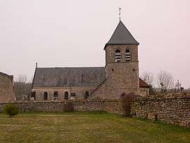
The parish church of Saint-Vincent, in Chemillé-sur-Indroi | |
 Chemillé-sur-Indrois | |
|
Location within Centre-Val de Loire region  Chemillé-sur-Indrois | |
| Coordinates: 47°09′42″N 1°10′00″E / 47.1617°N 1.1667°ECoordinates: 47°09′42″N 1°10′00″E / 47.1617°N 1.1667°E | |
| Country | France |
| Region | Centre-Val de Loire |
| Department | Indre-et-Loire |
| Arrondissement | Loches |
| Canton | Montrésor |
| Government | |
| • Mayor (2008–2014) | Henry Fremont |
| Area1 | 24.87 km2 (9.60 sq mi) |
| Population (2009)2 | 221 |
| • Density | 8.9/km2 (23/sq mi) |
| Time zone | CET (UTC+1) |
| • Summer (DST) | CEST (UTC+2) |
| INSEE/Postal code | 37069 / 37460 |
| Elevation | 82–142 m (269–466 ft) |
|
1 French Land Register data, which excludes lakes, ponds, glaciers > 1 km² (0.386 sq mi or 247 acres) and river estuaries. 2 Population without double counting: residents of multiple communes (e.g., students and military personnel) only counted once. | |
Chemillé-sur-Indrois is a commune in the Indre-et-Loire department in central France.
Geography
The Indrois flows west through the commune and crosses the village.
Population
| Historical population | ||
|---|---|---|
| Year | Pop. | ±% |
| 1793 | 520 | — |
| 1800 | 571 | +9.8% |
| 1806 | 572 | +0.2% |
| 1821 | 533 | −6.8% |
| 1831 | 525 | −1.5% |
| 1836 | 506 | −3.6% |
| 1841 | 528 | +4.3% |
| 1846 | 521 | −1.3% |
| 1851 | 556 | +6.7% |
| 1856 | 524 | −5.8% |
| 1861 | 506 | −3.4% |
| 1866 | 532 | +5.1% |
| 1872 | 497 | −6.6% |
| 1876 | 500 | +0.6% |
| 1881 | 520 | +4.0% |
| 1886 | 533 | +2.5% |
| 1891 | 551 | +3.4% |
| 1896 | 547 | −0.7% |
| 1901 | 562 | +2.7% |
| 1906 | 555 | −1.2% |
| 1911 | 542 | −2.3% |
| 1921 | 502 | −7.4% |
| 1926 | 517 | +3.0% |
| 1931 | 502 | −2.9% |
| 1936 | 502 | +0.0% |
| 1946 | 491 | −2.2% |
| 1954 | 443 | −9.8% |
| 1962 | 382 | −13.8% |
| 1968 | 339 | −11.3% |
| 1975 | 273 | −19.5% |
| 1982 | 250 | −8.4% |
| 1990 | 207 | −17.2% |
| 1999 | 197 | −4.8% |
| 2006 | 213 | +8.1% |
| 2009 | 221 | +3.8% |
See also
References
| Wikimedia Commons has media related to Chemillé-sur-Indrois. |
This article is issued from Wikipedia - version of the 2/18/2015. The text is available under the Creative Commons Attribution/Share Alike but additional terms may apply for the media files.