Monthodon
| Monthodon | |
|---|---|
|
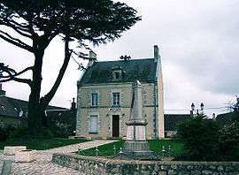
The town hall in Monthodon | |
 Monthodon | |
|
Location within Centre-Val de Loire region  Monthodon | |
| Coordinates: 47°39′02″N 0°50′14″E / 47.6506°N 0.8372°ECoordinates: 47°39′02″N 0°50′14″E / 47.6506°N 0.8372°E | |
| Country | France |
| Region | Centre-Val de Loire |
| Department | Indre-et-Loire |
| Arrondissement | Tours |
| Canton | Château-Renault |
| Government | |
| • Mayor (2008–2014) | Armel Baldyrou |
| Area1 | 33.91 km2 (13.09 sq mi) |
| Population (2009)2 | 630 |
| • Density | 19/km2 (48/sq mi) |
| Time zone | CET (UTC+1) |
| • Summer (DST) | CEST (UTC+2) |
| INSEE/Postal code | 37155 / 37110 |
| Elevation | 115–172 m (377–564 ft) |
|
1 French Land Register data, which excludes lakes, ponds, glaciers > 1 km² (0.386 sq mi or 247 acres) and river estuaries. 2 Population without double counting: residents of multiple communes (e.g., students and military personnel) only counted once. | |
Monthodon is a commune in the Indre-et-Loire department in central France.
Population
| Historical population | ||
|---|---|---|
| Year | Pop. | ±% |
| 1793 | 468 | — |
| 1800 | 534 | +14.1% |
| 1806 | 576 | +7.9% |
| 1821 | 585 | +1.6% |
| 1831 | 863 | +47.5% |
| 1836 | 858 | −0.6% |
| 1841 | 846 | −1.4% |
| 1846 | 805 | −4.8% |
| 1851 | 833 | +3.5% |
| 1856 | 815 | −2.2% |
| 1861 | 830 | +1.8% |
| 1866 | 810 | −2.4% |
| 1872 | 771 | −4.8% |
| 1876 | 748 | −3.0% |
| 1881 | 807 | +7.9% |
| 1886 | 809 | +0.2% |
| 1891 | 837 | +3.5% |
| 1896 | 903 | +7.9% |
| 1901 | 922 | +2.1% |
| 1906 | 940 | +2.0% |
| 1911 | 894 | −4.9% |
| 1921 | 824 | −7.8% |
| 1926 | 805 | −2.3% |
| 1931 | 858 | +6.6% |
| 1936 | 859 | +0.1% |
| 1946 | 852 | −0.8% |
| 1954 | 744 | −12.7% |
| 1962 | 701 | −5.8% |
| 1968 | 673 | −4.0% |
| 1975 | 579 | −14.0% |
| 1982 | 560 | −3.3% |
| 1990 | 547 | −2.3% |
| 1999 | 559 | +2.2% |
| 2006 | 621 | +11.1% |
| 2009 | 630 | +1.4% |
Sights
See also
References
| Wikimedia Commons has media related to Monthodon. |
This article is issued from Wikipedia - version of the 2/18/2015. The text is available under the Creative Commons Attribution/Share Alike but additional terms may apply for the media files.