Verneuil-sur-Indre
| Verneuil-sur-Indre | |
|---|---|
|
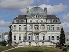
The Château of Verneuil-sur-Indre | |
 Verneuil-sur-Indre | |
|
Location within Centre-Val de Loire region  Verneuil-sur-Indre | |
| Coordinates: 47°03′25″N 1°02′34″E / 47.0569°N 1.0428°ECoordinates: 47°03′25″N 1°02′34″E / 47.0569°N 1.0428°E | |
| Country | France |
| Region | Centre-Val de Loire |
| Department | Indre-et-Loire |
| Arrondissement | Loches |
| Canton | Loches |
| Government | |
| • Mayor (2008–2014) | Philippe Bruneau |
| Area1 | 39.63 km2 (15.30 sq mi) |
| Population (2009)2 | 505 |
| • Density | 13/km2 (33/sq mi) |
| Time zone | CET (UTC+1) |
| • Summer (DST) | CEST (UTC+2) |
| INSEE/Postal code | 37269 / 37600 |
| Elevation | 73–149 m (240–489 ft) |
|
1 French Land Register data, which excludes lakes, ponds, glaciers > 1 km² (0.386 sq mi or 247 acres) and river estuaries. 2 Population without double counting: residents of multiple communes (e.g., students and military personnel) only counted once. | |
Verneuil-sur-Indre is a commune in the Indre-et-Loire department in central France.
Population
| Historical population | ||
|---|---|---|
| Year | Pop. | ±% |
| 1793 | 627 | — |
| 1800 | 694 | +10.7% |
| 1806 | 634 | −8.6% |
| 1821 | 722 | +13.9% |
| 1831 | 831 | +15.1% |
| 1836 | 838 | +0.8% |
| 1841 | 816 | −2.6% |
| 1846 | 811 | −0.6% |
| 1851 | 817 | +0.7% |
| 1856 | 793 | −2.9% |
| 1861 | 842 | +6.2% |
| 1866 | 824 | −2.1% |
| 1872 | 795 | −3.5% |
| 1876 | 800 | +0.6% |
| 1881 | 811 | +1.4% |
| 1886 | 858 | +5.8% |
| 1891 | 833 | −2.9% |
| 1896 | 843 | +1.2% |
| 1901 | 841 | −0.2% |
| 1906 | 825 | −1.9% |
| 1911 | 838 | +1.6% |
| 1921 | 851 | +1.6% |
| 1926 | 763 | −10.3% |
| 1931 | 760 | −0.4% |
| 1936 | 795 | +4.6% |
| 1946 | 815 | +2.5% |
| 1954 | 804 | −1.3% |
| 1962 | 736 | −8.5% |
| 1968 | 679 | −7.7% |
| 1975 | 576 | −15.2% |
| 1982 | 508 | −11.8% |
| 1990 | 462 | −9.1% |
| 1999 | 479 | +3.7% |
| 2006 | 494 | +3.1% |
| 2009 | 505 | +2.2% |
See also
References
| Wikimedia Commons has media related to Verneuil-sur-Indre. |
This article is issued from Wikipedia - version of the 2/11/2016. The text is available under the Creative Commons Attribution/Share Alike but additional terms may apply for the media files.