Chatel-Chéhéry
| Chatel-Chéhéry | |
|---|---|
 Chatel-Chéhéry | |
|
Location within Grand Est region  Chatel-Chéhéry | |
| Coordinates: 49°17′02″N 4°57′18″E / 49.2839°N 4.955°ECoordinates: 49°17′02″N 4°57′18″E / 49.2839°N 4.955°E | |
| Country | France |
| Region | Grand Est |
| Department | Ardennes |
| Arrondissement | Vouziers |
| Canton | Grandpré |
| Intercommunality | Argonne Ardennaise |
| Government | |
| • Mayor (2008–2014) | Alain Rickal |
| Area1 | 16.08 km2 (6.21 sq mi) |
| Population (2008)2 | 163 |
| • Density | 10/km2 (26/sq mi) |
| Time zone | CET (UTC+1) |
| • Summer (DST) | CEST (UTC+2) |
| INSEE/Postal code | 08109 / 08250 |
| Elevation | 129–246 m (423–807 ft) |
|
1 French Land Register data, which excludes lakes, ponds, glaciers > 1 km² (0.386 sq mi or 247 acres) and river estuaries. 2 Population without double counting: residents of multiple communes (e.g., students and military personnel) only counted once. | |
Chatel-Chéhéry is a commune in the Ardennes department in northern France.
Population
| Historical population | ||
|---|---|---|
| Year | Pop. | ±% |
| 1962 | 249 | — |
| 1968 | 279 | +12.0% |
| 1975 | 229 | −17.9% |
| 1982 | 183 | −20.1% |
| 1990 | 193 | +5.5% |
| 1999 | 140 | −27.5% |
| 2008 | 163 | +16.4% |
See also
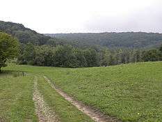
Valley near Chatel Chéhéry, France, where Sgt. York did his heroics in WWI.
References
| Wikimedia Commons has media related to Chatel-Chéhéry. |
This article is issued from Wikipedia - version of the 8/1/2016. The text is available under the Creative Commons Attribution/Share Alike but additional terms may apply for the media files.