Vireux-Molhain
| Vireux-Molhain | ||
|---|---|---|
|
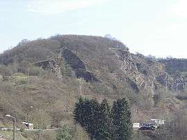
Mont Vireux | ||
| ||
 Vireux-Molhain | ||
|
Location within Grand Est region  Vireux-Molhain | ||
| Coordinates: 50°05′03″N 4°43′30″E / 50.0842°N 4.725°ECoordinates: 50°05′03″N 4°43′30″E / 50.0842°N 4.725°E | ||
| Country | France | |
| Region | Grand Est | |
| Department | Ardennes | |
| Arrondissement | Charleville-Mézières | |
| Canton | Givet | |
| Intercommunality | Ardennes Rives de Meuse | |
| Government | ||
| • Mayor (2008–2014) | Jean-Pol Devresse | |
| Area1 | 8.29 km2 (3.20 sq mi) | |
| Population (2008)2 | 1,674 | |
| • Density | 200/km2 (520/sq mi) | |
| Time zone | CET (UTC+1) | |
| • Summer (DST) | CEST (UTC+2) | |
| INSEE/Postal code | 08486 / 08320 | |
|
1 French Land Register data, which excludes lakes, ponds, glaciers > 1 km² (0.386 sq mi or 247 acres) and river estuaries. 2 Population without double counting: residents of multiple communes (e.g., students and military personnel) only counted once. | ||

Vireux-Molhain is a commune in the Ardennes department in northern France.
Population
| Historical population | ||
|---|---|---|
| Year | Pop. | ±% |
| 1793 | 542 | — |
| 1800 | 575 | +6.1% |
| 1806 | 621 | +8.0% |
| 1821 | 684 | +10.1% |
| 1831 | 773 | +13.0% |
| 1836 | 813 | +5.2% |
| 1841 | 832 | +2.3% |
| 1846 | 893 | +7.3% |
| 1851 | 939 | +5.2% |
| 1866 | 1,152 | +22.7% |
| 1872 | 1,194 | +3.6% |
| 1876 | 1,266 | +6.0% |
| 1881 | 1,431 | +13.0% |
| 1886 | 1,413 | −1.3% |
| 1891 | 1,291 | −8.6% |
| 1896 | 1,342 | +4.0% |
| 1901 | 1,387 | +3.4% |
| 1906 | 1,406 | +1.4% |
| 1911 | 1,492 | +6.1% |
| 1921 | 1,380 | −7.5% |
| 1926 | 1,432 | +3.8% |
| 1931 | 1,469 | +2.6% |
| 1936 | 1,379 | −6.1% |
| 1946 | 1,319 | −4.4% |
| 1954 | 1,467 | +11.2% |
| 1962 | 2,017 | +37.5% |
| 1968 | 1,939 | −3.9% |
| 1975 | 2,039 | +5.2% |
| 1982 | 1,936 | −5.1% |
| 1990 | 1,923 | −0.7% |
| 1999 | 1,835 | −4.6% |
| 2008 | 1,674 | −8.8% |
See also
References
| Wikimedia Commons has media related to Vireux-Molhain. |
This article is issued from Wikipedia - version of the 2/12/2016. The text is available under the Creative Commons Attribution/Share Alike but additional terms may apply for the media files.