Rocroi
| Rocroi | ||
|---|---|---|
 | ||
| ||
 Rocroi | ||
|
Location within Grand Est region  Rocroi | ||
| Coordinates: 49°55′34″N 4°31′20″E / 49.9261°N 4.5222°ECoordinates: 49°55′34″N 4°31′20″E / 49.9261°N 4.5222°E | ||
| Country | France | |
| Region | Grand Est | |
| Department | Ardennes | |
| Arrondissement | Charleville-Mézières | |
| Canton | Rocroi | |
| Government | ||
| • Mayor (2008–2014) | Michel Sobanska | |
| Area1 | 50.41 km2 (19.46 sq mi) | |
| Population (2008)2 | 2,386 | |
| • Density | 47/km2 (120/sq mi) | |
| Time zone | CET (UTC+1) | |
| • Summer (DST) | CEST (UTC+2) | |
| INSEE/Postal code | 08367 / 08230 | |
|
1 French Land Register data, which excludes lakes, ponds, glaciers > 1 km² (0.386 sq mi or 247 acres) and river estuaries. 2 Population without double counting: residents of multiple communes (e.g., students and military personnel) only counted once. | ||
.svg.png)
Rocroi is a commune in the Ardennes department in northern France.
The center was a fortified city, the walls of which are in the shape of a stylised star.
Population
| Historical population | ||
|---|---|---|
| Year | Pop. | ±% |
| 1793 | 3,260 | — |
| 1800 | 2,846 | −12.7% |
| 1806 | 3,008 | +5.7% |
| 1821 | 3,501 | +16.4% |
| 1831 | 3,173 | −9.4% |
| 1836 | 3,232 | +1.9% |
| 1841 | 3,780 | +17.0% |
| 1846 | 3,590 | −5.0% |
| 1851 | 3,765 | +4.9% |
| 1866 | 2,998 | −20.4% |
| 1872 | 2,281 | −23.9% |
| 1876 | 2,381 | +4.4% |
| 1881 | 2,977 | +25.0% |
| 1886 | 3,172 | +6.6% |
| 1891 | 2,265 | −28.6% |
| 1896 | 2,193 | −3.2% |
| 1901 | 2,176 | −0.8% |
| 1906 | 2,116 | −2.8% |
| 1911 | 2,256 | +6.6% |
| 1921 | 2,127 | −5.7% |
| 1926 | 2,442 | +14.8% |
| 1931 | 2,436 | −0.2% |
| 1936 | 2,250 | −7.6% |
| 1946 | 1,969 | −12.5% |
| 1954 | 2,348 | +19.2% |
| 1962 | 2,870 | +22.2% |
| 1968 | 2,997 | +4.4% |
| 1975 | 2,911 | −2.9% |
| 1982 | 2,789 | −4.2% |
| 1990 | 2,555 | −8.4% |
| 1999 | 2,420 | −5.3% |
| 2008 | 2,386 | −1.4% |
History
Rocroi was fortified by Francis I of France and expanded by Henry II of France. Because of its strategic location in the north of France it changed hands a number of times during wars. It is best known for the Battle of Rocroi in 1643.
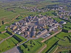
Rocroi seen from the air shows its defensive structure
See also
References
External links
| Wikimedia Commons has media related to Rocroi. |
This article is issued from Wikipedia - version of the 5/20/2015. The text is available under the Creative Commons Attribution/Share Alike but additional terms may apply for the media files.