Aire, Ardennes
| Aire | |
|---|---|
|
The Town Hall | |
 Aire | |
|
Location within Grand Est region  Aire | |
| Coordinates: 49°28′56″N 4°09′44″E / 49.4822°N 4.1622°ECoordinates: 49°28′56″N 4°09′44″E / 49.4822°N 4.1622°E | |
| Country | France |
| Region | Grand Est |
| Department | Ardennes |
| Arrondissement | Rethel |
| Canton | Asfeld |
| Intercommunality | Pays Rethélois |
| Government | |
| • Mayor (2014–2020) | Olivier Flauzac |
| Area1 | 6.29 km2 (2.43 sq mi) |
| Population (2009)2 | 218 |
| • Density | 35/km2 (90/sq mi) |
| Time zone | CET (UTC+1) |
| • Summer (DST) | CEST (UTC+2) |
| INSEE/Postal code | 08004 / 08190 |
| Elevation |
61–125 m (200–410 ft) (avg. 70 m or 230 ft) |
|
1 French Land Register data, which excludes lakes, ponds, glaciers > 1 km² (0.386 sq mi or 247 acres) and river estuaries. 2 Population without double counting: residents of multiple communes (e.g., students and military personnel) only counted once. | |
_Mairie.JPG)
Aire is a French commune in the Ardennes department in the Grand Est region of northern France.
Geography
Aire is some 15 km south by south west of Rethel midway on a direct line between Rethel and Guignicourt. The commune is traversed by Highway D926 running south-west from Blanzy-la-Salonnaise through the town of Aire and continuing south-west to Asfield. The only other access is by small country roads which criss-cross the commune. The commune is almost entirely farmland except for a small area of forest in the north. The Aisne river forms a small part of the northern border and the northern area of the commune is traversed by the Canal des Ardennes. There are no streams or hamlets in the commune.[1]
Neighbouring Communes and Villages[1]
 |
Villers-devant-le-Thour | Balham | Blanzy-la-Salonnaise | |
| Asfeld | |
Avançon | ||
| ||||
| | ||||
| Houdilcourt | Roizy | Tagnon |
_Canal_des_Ardennes.JPG)
History
The village suffered from fighting during the Wars of Religion between the Leaguers and the Calvinists in the wake of the killings at Gomont on the other side of the Aisne in May 1590.[2]
It also suffered fires that ravaged much of the village in 1770 and 1780.[2]
On the 1 March 1789 the inhabitants of the town, who were attached to the Bailiwick of Reims, wrote a list of grievances. The town then had 98 "fires". Through the concerns mentioned in this list of grievances some activities were highlighted, including the vineyards, and the cultivation of hemp that villagers wanted to rett in the river unmolested.[3]
Administration
List of Successive Mayors of Aire[4]
| From | To | Name | Party | Position |
|---|---|---|---|---|
| 1983 | 2001 | Michel Henry | ||
| 2001 | 2003 | Claude Gillet | ||
| 2003 | 2014 | Isabelle Henry | ||
| 2014 | 2020 | Olivier Flauzac |
(Not all data is known)
Demography
In 2009 the commune had 218 inhabitants. The evolution of the number of inhabitants is known through the population censuses conducted in the town since 1793. From the 21st century, a census of municipalities with fewer than 10,000 inhabitants is held every five years, unlike larger towns that have a sample survey every year.[Note 1]
| 1793 | 1800 | 1806 | 1821 | 1831 | 1836 | 1841 | 1846 | 1851 |
|---|---|---|---|---|---|---|---|---|
| 442 | 432 | 451 | 453 | 477 | 464 | 454 | 450 | 433 |
| 1856 | 1861 | 1866 | 1872 | 1876 | 1881 | 1886 | 1891 | 1896 |
|---|---|---|---|---|---|---|---|---|
| - | - | 395 | 352 | 336 | 311 | 298 | 296 | 278 |
| 1901 | 1906 | 1911 | 1921 | 1926 | 1931 | 1936 | 1946 | 1954 |
|---|---|---|---|---|---|---|---|---|
| 269 | 266 | 226 | 180 | 198 | 189 | 197 | 167 | 172 |
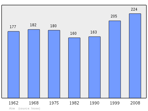
| 1962 | 1968 | 1975 | 1982 | 1990 | 1999 | 2009 | - | - |
|---|---|---|---|---|---|---|---|---|
| 177 | 182 | 180 | 160 | 163 | 205 | 218 | - | - |
Sources : Ldh/EHESS/Cassini until 1962, INSEE database from 1968 (population without double counting and municipal population from 2006)
Economy
Agriculture
There are three farming operations (EARL) headquartered in Aire, but many households are retired farmers, or farms in operation, but whose main buildings are in the nearby village. So the farmers, the old farmers, and their families occupy a large part though not the majority, of the population of Aire.
The farming activity is also significant.
Industries and services
There is no industrial area in Aire.
The commune of Aire has few services as the town is very small and the complete services are available in Asfeld, 4 kilometres away. There is a garage, a roofer, and a carpentry business in Aire.
Other services come from outside: the baker of the commune comes from Saint-Germainmont (but lives in Aire) passes through Aire every day.
Outside of farmers and artisans working on site or nearby, employment in Aire is split between the towns of Rethel and of Reims through commuting.
Two cottages offer accommodation next to the pond in Aire.[5]
Local life
The Association of Flying Fools of Aire consists of fifteen model aircraft enthusiasts who have a flying field 250 metres by 30 metres.[6]
Sites and Monuments
- The Church contains a painted Tribune (1588)
 [7] which is registered as an historical object.[8]
 - The Étang d'Aire (Pond of Aire)
- Aire is a stage on the Route Porcien[9]
-
_%C3%89glise.JPG)
Church
-
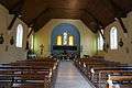
The nave of the church
-
_Monument_aux_morts.JPG)
War Memorial
-
_Croix_de_chemin.JPG)
Wayside Cross
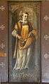
- Paintings in the Church
-

Barbe
-
Estienne
-
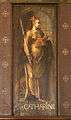
Catherine
-

Clere
-

Laurent
-

Eloy
See also
External links
- Aire on the old National Geographic Institute website
- Aire on Lion1906
- Aire on Google Maps
- Aire on Géoportail, National Geographic Institute (IGN) website (French)
- Aire on the 1750 Cassini Map
- Aire on the INSEE website (French)
- INSEE (French)
Notes and references
Notes
- ↑ At the beginning of the 21st century, the methods of identification have been modified by law No. 2002-276 of 27 February 2002 , the so-called "law of local democracy" and in particular Title V "census operations" which allow, after a transitional period running from 2004 to 2008, the annual publication of the legal population of the different French administrative districts. For municipalities with a population greater than 10,000 inhabitants, a sample survey is conducted annually, the entire territory of these municipalities is taken into account at the end of the period of five years. The first "legal population" after 1999 under this new law came into force on 1 January 2009 and was based on the census of 2006.
References
- 1 2 Google Maps
- 1 2 Albert Meyrac, Illustrated Geography of the Ardennes, Paris, 1965 (French)
- ↑ The Ardennes list of grievances book, published by lmes Departmental Archives of the Ardennes and the Ardennes mixed Normal School on the occasion of the bicentenary of the French Revolution, Publication of the General Council of the Ardennes, 1989 ISBN 2-86008-000-7. (French)
- ↑ List of Mayors of France (French)
- ↑ Holiday Cottages in Aire on the Departmental Tourism Committee of Ardennes website (French)
- ↑ Association of Flying Fools of Aire, the passion for model aeroplanes, La semaine des Ardennes 23 February 2012 (French)
- ↑ Henri Jadart, Painted Tribune in the Church at Aire, Édition H. Delesques, 1894. (French)
- ↑ Ministry of Culture, Palissy PM08000011 Tribune (French)
- ↑ A tourist route defined by the Ardennes Tourist Office.
| Wikimedia Commons has media related to Aire, Ardennes. |