Ballay
| Ballay | |
|---|---|
|
Entrance to Ballay | |
 Ballay | |
|
Location within Grand Est region  Ballay | |
| Coordinates: 49°25′51″N 4°45′00″E / 49.4308°N 4.75°ECoordinates: 49°25′51″N 4°45′00″E / 49.4308°N 4.75°E | |
| Country | France |
| Region | Grand Est |
| Department | Ardennes |
| Arrondissement | Vouziers |
| Canton | Vouziers |
| Intercommunality | Argonne Ardennaise |
| Government | |
| • Mayor (2008–2020) | Christian Mielcarek |
| Area1 | 10.46 km2 (4.04 sq mi) |
| Population (2010)2 | 248 |
| • Density | 24/km2 (61/sq mi) |
| Time zone | CET (UTC+1) |
| • Summer (DST) | CEST (UTC+2) |
| INSEE/Postal code | 08045 / 08400 |
| Elevation |
91–221 m (299–725 ft) (avg. 100 m or 330 ft) |
|
1 French Land Register data, which excludes lakes, ponds, glaciers > 1 km² (0.386 sq mi or 247 acres) and river estuaries. 2 Population without double counting: residents of multiple communes (e.g., students and military personnel) only counted once. | |

Ballay is a French commune in the Ardennes department in the Grand Est region of northern France.
The inhabitants of the commune are known as Ballayriots or Ballayriottes.[1]
Geography
Ballay is located some 35 km east by south-east of Rethel and 3 km north of Vouziers. Access to the commune is by the D977 road from Vouziers which passes through the centre of the commune and the village and continues north to Quatre-Champs. The D19 road from Quatre-Champs to Vandy forms part of the northern border of the commune. Apart from the village there are the hamlets of Claire-Fontaine, Landèves, and La Noue Adam. The commune is mostly forested in the east and west with farmland down the centre.[2]
The Aisne river forms the south-western border of the commune as it flows north to eventually join the Oise at Clairoix. The Fournelles flows through the centre of the commune from the north and joins the Aisne on the south-western border. Several tributaries rise in the commune and feed the Fournelles including the Martignère, the Ruisseau du Moulin des Bois, and the Chalan which forms part of the southern border of the commune.[2]
Clairefontaine and Landèves were municipalities in 1790 and merged into Ballay at the end of 1790.
Neighbouring communes and villages[2]
 |
Vandy | Quatre-Champs | | |
| Vrizy | |
Toges | ||
| ||||
| | ||||
| Vouziers | Falaise | La Croix-aux-Bois |
History
In the 12th century Ballay was a lordship with a castle and a parish with a church dedicated to Notre-Dame which was an annex to Vandy. An Augustinian Priory, Notre-Dame of Landèves, was founded at Landèves in 1219 by two brother lords of Bally who made it religious. Since its foundation the priory served the parish of Ballay. The priory became an abbey in 1623. The abbey and church were destroyed during the French Revolution.
Administration
| From | To | Name | Party | Position |
|---|---|---|---|---|
| 1995 | 2008 | Jean-Luc Payer | ||
| 2008 | 2020 | Christian Mielcarek |
(Not all data is known)
Demography
In 2010 the commune had 248 inhabitants. The evolution of the number of inhabitants is known from the population censuses conducted in the commune since 1793. From the 21st century, a census of communes with fewer than 10,000 inhabitants is held every five years, unlike larger communes that have a sample survey every year.[Note 1]
| 1793 | 1800 | 1806 | 1821 | 1831 | 1836 | 1841 | 1846 | 1851 |
|---|---|---|---|---|---|---|---|---|
| 434 | 502 | 490 | 447 | 461 | 473 | 475 | 473 | 471 |
| 1856 | 1861 | 1866 | 1872 | 1876 | 1881 | 1886 | 1891 | 1896 |
|---|---|---|---|---|---|---|---|---|
| - | - | 417 | 390 | 375 | 350 | 382 | 374 | 373 |
| 1901 | 1906 | 1911 | 1921 | 1926 | 1931 | 1936 | 1946 | 1954 |
|---|---|---|---|---|---|---|---|---|
| 336 | 332 | 346 | 331 | 303 | 283 | 300 | 307 | 290 |
| 1962 | 1968 | 1975 | 1982 | 1990 | 1999 | 2006 | 2010 | - |
|---|---|---|---|---|---|---|---|---|
| 315 | 267 | 265 | 230 | 254 | 245 | 243 | 248 | - |
Sources : Ldh/EHESS/Cassini until 1962, INSEE database from 1968 (population without double counting and municipal population from 2006)


Sites and monuments

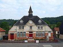
- The Town Hall/School at Rue Notre-Dame (1925)
 [4]
[4] - The Church of Notre-Dame at Rue Notre-Dame (1925)[5]
- A Flour Mill at Landèves (1921)[6] The Flour Mill contains several items that are registered as historical objects:
See also
External links
- Ballay on the old National Geographic Institute website (French)
- Ballay on Lion1906
- Ballay on Google Maps
- Ballay on Géoportail, National Geographic Institute (IGN) website (French)
- Balay on the 1750 Cassini Map
- Ballay on the INSEE website (French)
- INSEE (French)
Notes and references
Notes
- ↑ At the beginning of the 21st century, the methods of identification have been modified by Law No. 2002-276 of 27 February 2002, the so-called "law of local democracy" and in particular Title V "census operations" allows, after a transitional period running from 2004 to 2008, the annual publication of the legal population of the different French administrative districts. For communes with a population greater than 10,000 inhabitants, a sample survey is conducted annually, the entire territory of these communes is taken into account at the end of the period of five years. The first "legal population" after 1999 under this new law came into force on 1 January 2009 and was based on the census of 2006.
References
- ↑ Inhabitants of Ardennes (French)
- 1 2 3 Google Maps
- ↑ List of Mayors of France (French)
- ↑ Ministry of Culture, Mérimée EA08000002 Town Hall/School (French)
- ↑ Ministry of Culture, Mérimée EA08000001 Church of Notre-Dame (French)
- ↑ Ministry of Culture, Mérimée IA08000325 Flour Mill (French)
- ↑ Ministry of Culture, Palissy IM08000173 Separator Machine (French)
- ↑ Ministry of Culture, Palissy IM08000172 Grinding Machine (French)
- ↑ Ministry of Culture, Palissy IM08000171 Cleaning Machine (French)
- ↑ Ministry of Culture, Palissy IM08000170 Ossberger Hydraulic Turbine (French)
| Wikimedia Commons has media related to Ballay. |