Authe
| Authe | ||
|---|---|---|
|
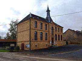
Town hall | ||
| ||
 Authe | ||
|
Location within Grand Est region  Authe | ||
| Coordinates: 49°27′36″N 4°52′47″E / 49.46°N 4.8797°ECoordinates: 49°27′36″N 4°52′47″E / 49.46°N 4.8797°E | ||
| Country | France | |
| Region | Grand Est | |
| Department | Ardennes | |
| Arrondissement | Vouziers | |
| Canton | Chesne | |
| Intercommunality | Argonne Ardennaise | |
| Government | ||
| • Mayor (2001–2020) | Sylvie Lefort | |
| Area1 | 9.47 km2 (3.66 sq mi) | |
| Population (2010)2 | 92 | |
| • Density | 9.7/km2 (25/sq mi) | |
| Time zone | CET (UTC+1) | |
| • Summer (DST) | CEST (UTC+2) | |
| INSEE/Postal code | 08033 / 08240 | |
| Elevation |
164–225 m (538–738 ft) (avg. 172 m or 564 ft) | |
|
1 French Land Register data, which excludes lakes, ponds, glaciers > 1 km² (0.386 sq mi or 247 acres) and river estuaries. 2 Population without double counting: residents of multiple communes (e.g., students and military personnel) only counted once. | ||
Authe is a French commune in the Ardennes department in the Grand Est region of northern France.
The inhabitants of the commune are known as Authois or Authoises.[1]
Geography
Authe is located some 45 km east by south-east of Rethel and 20 km north-east of Vouziers. Access to the commune is by road D12 from Brieulles-sur-Bar in the north which passes through the centre of the commune and the village and continues south to join the D947 south of the commune. The commune consists entirely of farmland.[2]
The Bar river forms the south-western border of the commune as it flows north-west to follow the Canal des Ardennes to join the Meuse near Vrigne-Meuse. The Ruisseau de Saint-Pierremont flows from the north-east of the commune past the village and joins the Bar on the south-western border of the commune.[2]
Neighbouring communes and villages[2]
 |
Noirval | Verrières | Saint-Pierremont | |
| Belleville-et-Châtillon-sur-Bar | |
|||
| ||||
| | ||||
| Boult-aux-Bois | Germont | Autruche |
Heraldry
 |
Blazon: Party per pale Vert and Gules a wolf's head cabossed of Argent debruised by the division, in chief Sable charged with three fleurs-de-lis of Argent. |
Administration

List of Successive Mayors[3]
| From | To | Name | Party | Position |
|---|---|---|---|---|
| 2001 | 2020 | Sylvie Lefort |
(Not all data is known)
Demography
In 2010 the commune had 92 inhabitants. The evolution of the number of inhabitants is known from the population censuses conducted in the commune since 1793. From the 21st century, a census of communes with fewer than 10,000 inhabitants is held every five years, unlike larger communes that have a sample survey every year.[Note 1]
| 1793 | 1800 | 1806 | 1821 | 1831 | 1836 | 1841 | 1846 | 1851 |
|---|---|---|---|---|---|---|---|---|
| 336 | 331 | 347 | 365 | 406 | 396 | 370 | 394 | 378 |
| 1856 | 1861 | 1866 | 1872 | 1876 | 1881 | 1886 | 1891 | 1896 |
|---|---|---|---|---|---|---|---|---|
| - | - | 349 | 342 | 367 | 365 | 361 | 351 | 337 |
| 1901 | 1906 | 1911 | 1921 | 1926 | 1931 | 1936 | 1946 | 1954 |
|---|---|---|---|---|---|---|---|---|
| 334 | 311 | 280 | 245 | 243 | 211 | 184 | 164 | 141 |
| 1962 | 1968 | 1975 | 1982 | 1990 | 1999 | 2006 | 2010 | - |
|---|---|---|---|---|---|---|---|---|
| 143 | 125 | 96 | 87 | 83 | 94 | 93 | 92 | - |
Sources : Ldh/EHESS/Cassini until 1962, INSEE database from 1968 (population without double counting and municipal population from 2006)

Culture and heritage

Religious heritage
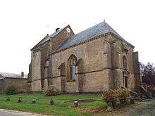
The commune has one religious building registered as an historical monument:
- The Church of Saint-Martin (14th century)
 [4]
[4]
See also
External links
- Authe on Lion1906
- Authe on Google Maps
- Authe on Géoportail, National Geographic Institute (IGN) website (French)
- Authe on the 1750 Cassini Map
- Authe on the INSEE website (French)
- INSEE (French)
Notes and references
Notes
- ↑ At the beginning of the 21st century, the methods of identification have been modified by Law No. 2002-276 of 27 February 2002, the so-called "law of local democracy" and in particular Title V "census operations" allows, after a transitional period running from 2004 to 2008, the annual publication of the legal population of the different French administrative districts. For communes with a population greater than 10,000 inhabitants, a sample survey is conducted annually, the entire territory of these communes is taken into account at the end of the period of five years. The first "legal population" after 1999 under this new law came into force on 1 January 2009 and was based on the census of 2006.
References
- ↑ Inhabitants of Ardennes (French)
- 1 2 3 Google Maps
- ↑ List of Mayors of France (French)
- ↑ Ministry of Culture, Mérimée PA00078336 Church of Saint-Martin (French)

| Wikimedia Commons has media related to Authe. |