Castolon
|
Castolon Historic District | |
|
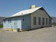
Army Officers' Quarters, Castolon | |
  | |
| Location | Along Rio Grande at jct. of Park Rtes. 5, 9, and 35, Big Bend National Park, Texas |
|---|---|
| Coordinates | 29°7′48″N 103°30′47″W / 29.13000°N 103.51306°WCoordinates: 29°7′48″N 103°30′47″W / 29.13000°N 103.51306°W |
| Area | 800 acres (320 ha) |
| NRHP Reference # | [1] |
| Added to NRHP | September 6, 1974 |
Castolon, also known as La Harmonia Ranch and Campo Santa Helena, was a small community in southwestern Texas, located in what is now Big Bend National Park along the Rio Grande. The location was first settled in 1901 by Cipriano Hernandez, who farmed the area and built the original Castolon Store, now known as the Alvino House.
History
The area began to attract refugees from nearby Mexico who were fleeing the Mexican Revolution of 1910. The Castolon area was the site on a U.S. Army encampment, called Campo Santa Helena, to house units patrolling the Mexican-American border. However, by the time the camp was complete in 1920 the border was quiet and the camp buildings were never used by the Army. In 1921 the La Harmonia Company was established in the barracks, operating a trading post and farming cotton.[2] The La Harmonia Company was established in 1918 by Howard Perry, who owned the Chisos Mining Company in Terlingua, in partnership with Wayne Cartledge. Cartledge and his son Eugene chose the name and managed the company. The La Harmonia Company lasted until 1961, when it was sold to the National Park Service. The store continues to be operated by a park concessioner.[3]
Description
Castolon is divided into two areas. "Old Castolon" comprises the Old Castolon Store, a cafe-residence and a shed. The Army Compound includes a barracks, now the Castolon Store, a recreation hall, latrine, two officers' residences, a granary and tack room, and the Magdalena, Garlick and Alvino residences. The Magdalena and Garlick houses post-date the Army construction and are associated with La Harmonia Ranch, while the Alvino house pre-dates the Army. All of the buildings are built with adobe walls, and most are roofed with corrugated metal roofing. A few use traditional vigas, latillas and a soil roof covering.[4]
Castolon was placed on the National Register of Historic Places on September 6, 1974.[1]
Climate
- Coordinates: 29°08′04″N 103°30′54″W / 29.13444°N 103.515°W
- Elevation: 2,169 feet (661 m)[5]
| Climate data for Castolon, Texas (Feb 1, 1947–Mar 31, 2013) | |||||||||||||
|---|---|---|---|---|---|---|---|---|---|---|---|---|---|
| Month | Jan | Feb | Mar | Apr | May | Jun | Jul | Aug | Sep | Oct | Nov | Dec | Year |
| Record high °F (°C) | 90 (32) |
97 (36) |
105 (41) |
109 (43) |
115 (46) |
117 (47) |
115 (46) |
114 (46) |
110 (43) |
105 (41) |
99 (37) |
90 (32) |
117 (47) |
| Average high °F (°C) | 68.2 (20.1) |
74.4 (23.6) |
82.9 (28.3) |
91.9 (33.3) |
99.8 (37.7) |
103.4 (39.7) |
102.2 (39) |
101.1 (38.4) |
96.3 (35.7) |
88.5 (31.4) |
77.7 (25.4) |
68.4 (20.2) |
87.9 (31.1) |
| Daily mean °F (°C) | 51.4 (10.8) |
57.0 (13.9) |
65.0 (18.3) |
73.8 (23.2) |
83.0 (28.3) |
88.3 (31.3) |
88.3 (31.3) |
87.3 (30.7) |
82.4 (28) |
73.0 (22.8) |
61.0 (16.1) |
51.7 (10.9) |
71.8 (22.1) |
| Average low °F (°C) | 34.5 (1.4) |
39.5 (4.2) |
47.1 (8.4) |
56.2 (13.4) |
66.2 (19) |
73.1 (22.8) |
74.4 (23.6) |
73.5 (23.1) |
68.6 (20.3) |
57.7 (14.3) |
44.2 (6.8) |
35.4 (1.9) |
55.9 (13.3) |
| Record low °F (°C) | 7 (−14) |
5 (−15) |
22 (−6) |
28 (−2) |
44 (7) |
42 (6) |
60 (16) |
64 (18) |
47 (8) |
29 (−2) |
21 (−6) |
7 (−14) |
5 (−15) |
| Average precipitation inches (mm) | 0.37 (9.4) |
0.29 (7.4) |
0.23 (5.8) |
0.41 (10.4) |
0.96 (24.4) |
1.45 (36.8) |
1.71 (43.4) |
1.62 (41.1) |
1.47 (37.3) |
1.06 (26.9) |
0.36 (9.1) |
0.30 (7.6) |
10.24 (260.1) |
| Average snowfall inches (cm) | 0.0 (0) |
0.0 (0) |
0.0 (0) |
0.0 (0) |
0.0 (0) |
0.0 (0) |
0.0 (0) |
0.0 (0) |
0.0 (0) |
0.0 (0) |
0.0 (0) |
0.0 (0) |
0.0 (0) |
| Average precipitation days (≥ 0.001 in) | 2.73 | 1.89 | 1.38 | 1.95 | 3.97 | 5.22 | 6.46 | 5.89 | 5.37 | 3.72 | 2.00 | 2.37 | 41.90 |
| Source: Western Regional Climate Center, Desert Research Institute[6] | |||||||||||||
References
- 1 2 National Park Service (2009-03-13). "National Register Information System". National Register of Historic Places. National Park Service.
- ↑ "History of the Castolon Area". Big Bend National Park. National Park Service. Retrieved 20 July 2011.
- ↑ "La Harmonia Store". Big Bend National Park. National Park Service. Retrieved 20 July 2011.
- ↑ Battle, David G. (February 1974). "National Register of Historic Places Inventory - Nomination Form: Castolon" (PDF). National Park Service. Retrieved 20 July 2011.
- ↑ "US COOP Station Map". Western Regional Climate Center, Desert Research Institute. Retrieved May 5, 2015.
- ↑ "CASTOLON, TEXAS (411524), Period of Record Monthly Climate Summary". Western Regional Climate Center, Desert Research Institute. Retrieved May 5, 2015.
External links
| Wikimedia Commons has media related to Castolon. |
- Castolon at Big Bend National Park (and subpages)
- Several buildings of Castolon have been documented by the Historic American Buildings Survey


Municipalities and communities of Brewster County, Texas, United States | ||
|---|---|---|
| City | 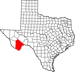 | |
| CDPs | ||
| Other unincorporated communities | ||
| Ghost Towns | ||
| Annexed former counties | ||