Bunratty
| Bunratty Bun na Raite | |
|---|---|
| Civil parish | |
|
Buildings in Bunratty village | |
 Bunratty Location in Ireland | |
| Coordinates: 52°42′29″N 8°49′35″W / 52.708011°N 8.826512°WCoordinates: 52°42′29″N 8°49′35″W / 52.708011°N 8.826512°W | |
| Country | Ireland |
| Province | Munster |
| County | County Clare |
| Time zone | WET (UTC+0) |
| • Summer (DST) | IST (WEST) (UTC-1) |
| Website |
www |

Bunratty (Irish: Bun na Raite, meaning "End of the Raite river"[1]) is a civil parish in County Clare, Ireland, and a small village by the same name. The village is located next to a major tourist attraction, Bunratty Castle, on the N18 connecting Limerick to Galway. The Raite river defines the eastern boundary of the parish, and flows into the Shannon Estuary, which defines the southern boundary.
History
The first settlement in Bunratty may have been set up by Vikings in the 10th century. The Annals of the Four Masters report that Brian Boru destroyed a Viking settlement in the area in 977.[2]
Around 1250 the Anglo-Norman ruler Mucegros was given the right to hold a market and fair at Bunratty. He built the castle in 1277. The castle became the main residence of Richard de Clare, owner of all of Thomond.[3] In the late 13th century, Bunrattty had about 1,000 inhabitants.[4] Richard de Clare was killed in 1311, and in 1314 the town of Bunratty was burned to the ground by the local people. The castle was sacked in 1332.[3]
The current Bunratty Castle was built by the MacNamara family in the early part of the 15th century. It later became property of the O'Briens, who eventually made it their principal seat as Earls of Thomond. In the early 18th century it came into the possession of the Studdert family, who built Bunratty House in 1804.[2][5]
In 1834 Bunratty parish had 55 Protestants and 1,340 Catholics. As of 1841 there were 1,320 people in 207 houses. The parish was crossed by the road from Limerick to Ennis, which ran past the castle. In the Roman Catholic system, Bunratty parish was united with Tomfinlough and Kilconry parishes. As of 1845 the castle was being used as a barracks by the Royal Irish Constabulary.[3] During the Great Famine (1845 to 1852) Bunratty's population fell into decline.[6]
Bunratty is the location of the death of the last British soldier to die in Clare during the Irish War of Independence. Private William Reginald Williams of the Royal Welch Fusiliers was fatally injured in a motorcycle accident on 7 July 1921, just four days before both sides came to a truce. Though Williams' body was never recovered, a Commonwealth War Grave in his memory lies in the north-east corner of the old Bunratty graveyard adjacent to the Bunratty Castle Hotel.[7].
In the 1950s, Bunratty’s most prominent structure, the then ruined Bunratty Castle, attracted the attention of John Hunt, Lord Gort and the Irish Government.[8] The castle was extensively renovated and opened to the public in 1960. Although Bunratty Castle thrived, becoming a major draw for early transatlantic tourists, the village population continued to decline.
Location
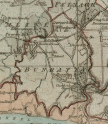
Bunratty parish lies on the north shore of the River Shannon to the east of Drumline parish, south and west of Feenagh parish and west of Kilfintinan parish. The Raite River, which flows into the Shannon, defines the eastern boundary of the parish.[9][lower-alpha 1] The parish is about 2.75 by 2.25 miles (4.43 by 3.62 km).[3] The civil parish of Bunratty has the same extent as the medieval parish of Bunratty. It is no longer an administrative unit.[10] It is part of the barony of Bunratty Lower.[11]
Bunratty Castle overlooks the Raite river.[9] The village lies to the west of the castle. It has few residents and is not counted as a village in the Irish Census.[12] Bunratty parish is today part of the Catholic parish of Newmarket-on-Fergus which also contains the civil parishes of Clonloghan, Drumline, Kilconry, Kilmaleery, Kilnasoolagh and Tomfinlough.[13]
Economy
Roadstone Wood operates a quarry in the center of the parish. It produces stone, blocks, concrete, mortar and blacktop.[14] Eoin Gavin Transport has its road haulage office in Bunratty.[15] The company founder, Eoin Gavin, began as the operator of an eight-wheel tipper from the quarry.[16] Prior to the construction of the N18 bypass, the main road from Limerick and Shannon Airport to Ennis passed through the village.
Bunratty village itself caters mainly to tourists visiting Bunratty Castle and the Bunratty Folk Park. Besides Durty Nellys, styling itself as one of Ireland's oldest pubs, there are a number of other pubs/restaurants. The village also provides accommodation in the form of hotels and bed&breakfasts. Several shops also cater to the needs of travellers and tourists.
Gallery
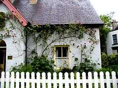 Rose Cottage in Bunratty folk park
 Cottages in the folk park
.jpg) Bunratty Castle before 1914
Bunratty Castle before 1914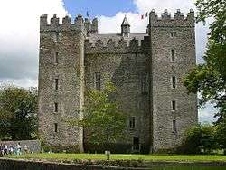 Bunratty Castle 2002
 Church in the castle grounds
References
Notes
Citations
- ↑ "Bun Raite". Placenames Database of Ireland. Retrieved 2014-04-10.
- 1 2 Ryan, William Gerrard (1979). "A Survey of Monuments of Archaeological and Historical Interest in the Barony of Bunratty Lower, Co. Clare, Part 4: Castles and tower houses c.1500, Chapter 33: Bunratty Parish". Clare Library. Retrieved 17 August 2013.
- 1 2 3 4 5 "Bunratty". Parliamentary Gazeteer of Ireland 1845. Retrieved 2014-03-03.
- ↑ Lynch, Christopher (1977), "Bunratty Castle - a short history" (PDF), The Other Clare, 1: 17–18
- ↑ "Landed estates database: Bunratty House". NUI Galway. Retrieved 17 August 2013.
- ↑ "Landed estates database: Bunratty Castle". NUI Galway. Retrieved 17 August 2013.
- ↑ Ó Ruairc, Pádraig Óg, Blood on the Banner: The Republican Struggle in Clare (Cork, 2009)
- ↑ "Landed estates database: Studdert (Bunratty)". NUI Galway. Retrieved 17 August 2013.
- 1 2 "1842 Maps Clare". Clare County Library. Retrieved 2014-03-03.
- ↑ "Clare Civil Parishes". Clare County Library. Retrieved 2014-03-03.
- ↑ "Barony of Bunratty (Lower and Upper)". Parliamentary Gazeteer of Ireland. 1845. Retrieved 2014-03-09.
- ↑ "Census 2011 - Preliminary results". Central Statistics Office Ireland. Retrieved 2014-03-04.
- ↑ "Parishes and Church Records". Clare County Library. Retrieved 2014-03-03.
- ↑ "Roadstone Wood Locations". Roadstone Wood. Retrieved 2014-03-03.
- ↑ "Home". Eoin Gavin Transport. Retrieved 2014-03-03.
- ↑ "The man in charge of the Irish RHA". Commercial Motor. 11 August 2011. Retrieved 2014-03-04.
External links
| Wikimedia Commons has media related to Bunratty. |
- National Inventory of Architectural Heritage: Bunratty Castle
- National Inventory of Architectural Heritage: Bunratty Bridge
- National Inventory of Architectural Heritage: Bunratty House
- National Inventory of Architectural Heritage: Bunratty Castle Hotel
Places in County Clare | ||
|---|---|---|
| Towns | 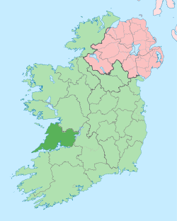 | |
| Villages |
| |
| Regions | ||
| Islands | ||
| ||