Brockley Hill
| Brockley Hill | |
 View of Brockley Hill |
|
 Brockley Hill |
|
| OS grid reference | TQ174940 |
|---|---|
| London borough | Harrow |
| Ceremonial county | Greater London |
| Region | London |
| Country | England |
| Sovereign state | United Kingdom |
| Post town | HARROW |
| Postcode district | HA7 |
| Dialling code | 020 |
| EU Parliament | London |
| London Assembly | Brent and Harrow |
Coordinates: 51°38′N 0°18′W / 51.63°N 0.3°W
Brockley Hill, Stanmore, on the outskirts of North London, England, rises to 136 metres (446 ft) above sea level. The road leading over it is also named Brockley Hill. The area is associated with the archaeological site called Sulloniacis. Its most prominent building is the Royal National Orthopaedic Hospital.
Etymology
In its present form the name dates from the 16th century; the earlier form was Brokhole(s): 'badger-holes', from the old English and Celtic word Brock.[1] The sandy soil of the hill-top is more attractive to burrowing animals like badgers, than the heavy London clay of the surrounding areas.[2]
Geography
Geology
Brockley Hill is the eastern arm of a long hill centred on Stanmore. The top of the hill is capped with "Stanmore Gravel", which is the remnant of a layer of gravel laid down by a river system pre-dating the Thames. Under the gravel are layers of sand, silt and clay about 15 metres thick known as the Claygate Beds. Below this is London Clay about 70 metres thick.[3] This arrangement is typical of hills bounding the Thames Valley.
Roads
The highway originally built by the Romans, which we know as Watling Street or more recently the A5 trunk road, rises steeply from the junction with Spur Road, Edgware, to the summit of Brockley Hill, climbing some 70m in a distance of about 1,400 metres. The descent from the summit to Elstree Hill Roundabout about 600m to the North drops about 30m.
The M1 motorway and the A41 Watford Way trunk road both pass through the valley between Brockley Hill and Elstree Hill to the North.
Administrative area
Brockley Hill was in Stanmore, Gore Hundred, in the County of Middlesex until the abolition of Middlesex in 1965. Since then the road named Brockley Hill, including the properties on both sides of it, and all the fields and properties to the west, are in Stanmore, in the London Borough of Harrow; the fields to the east of the road are in Edgware, London Borough of Barnet.
Nearby places
History
Watling Street was constructed during the early part of the Roman occupation. The section running roughly North from Marble Arch runs in a straight line as far as the summit of Brockley Hill, following which there is a double curve to meet the alignment of the next section. The Roman engineers' practice was to use a high point as a sighting-point[4] and clearly Brockley Hill was used in this way. The sandy clay found at the top of the hill was used for the manufacture of pottery during the Roman period, and it was one of the most important potteries in southern Britain in the later first century.[5][6]
The antiquarian Daniel Lysons noted the long history of Roman finds in the area in his 1795 book The Environs of London: volume 3: County of Middlesex and quoted a country proverb: "No heart can think, nor tongue can tell, what lies between Brockley-hill and Pennywell", which he interprets in terms of finding Roman treasure. Pennywell is in Elstree, some 1,500 metres north of Brockley Hill. What now lies between Brockley Hill and Pennywell includes eight lanes of fast moving traffic, as both the M1 motorway and the A41 Watford Bypass pass through this area.
The Eastern end of the Dark Ages linear earthwork known as Grim's Ditch or Grimsdyke is close to Brockley Hill.
Bricks were made on the Hill in the 18th century.
The first hospital on the site of the Royal National Orthopaedic Hospital was founded in 1882; the RNOH bought the site and premises in 1920.
In the 1930s an extension of the Northern line of the London Underground was planned to run from Edgware to Bushey Heath with a station called Brockley Hill in a field at the foot of the hill. Brick arches were constructed (their remains are still visible in 'Arches Field') but work was abandoned for the duration of World War II. After the war further major housing development was banned in the area and the station was never finished.
References
- ↑ Gover JEB, Mawer and Stenton, The place-names of Middlesex apart from the City of London. Nottingham, reprinted 1994 (English Place-Name Society volume XVIII).
- ↑ Bromehead CEN, 1925, The Geology of North London. London, HMSO, p.13.
- ↑ British Geological Survey. 1993. 1:50 000 series England and Wales Sheet 256 North London Solid and Drift Geology. Keyworth, Nottingham. British Geological Survey.
- ↑ Margary, Ivan D, Roman Roads in Britain. London, 1955 (revised edition, 1967).
- ↑ Hendon and District Archaeological Society, Edited by Pamela Taylor, A Place In Time. Hendon, 1989.
- ↑ Mattingly, David (2006). An Imperial Possession: Britain in the Roman Empire. Penguin. pp. 514, 516. ISBN 978-0-14-014822-0.
External links
- Royal National Orthopaedic Hospital
- Brockley Hill Golf Centre
- Victoria County History on Little Stanmore - includes extract from Lysons
- SS Brockley Hill, sunk in 1941
- Oxford Archaeology report on two excavations
| Districts | 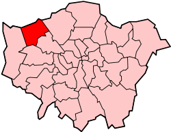 | |
|---|---|---|
| Attractions | ||
| Parks and open spaces |
| |
| Constituencies | ||
| Tube and rail stations | ||
| Other topics | ||
| Royal parks | 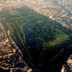 | |
|---|---|---|
| Large urban parks |
| |
| Country parks | ||
| Commons | ||
| Marshes & Wetlands | ||
| Woodland | ||
| House gardens |
| |
| Entry-fee charging | ||
| Community gardens |
| |