Barnes Common
| Barnes Common | |
|---|---|
|
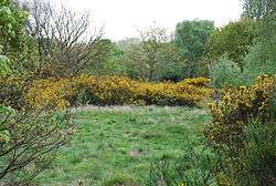
Broom on Barnes Common | |
| Type | Common land |
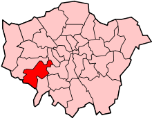
| Location | Barnes, London |
| Area | 49.55 hectares (122.4 acres) |
| Open | All year |
| Status | Local Nature Reserve[1] |
Barnes Common is common land in the south east of Barnes, London, England, adjoining Putney Lower Common to the east and bounded to the south by the Upper Richmond Road.[2] Along with Barnes Green, it is one of the largest areas of common land in London with 49.55 hectares (122.4 acres) of protected commons.[3] It is also a Local Nature Reserve.[1] Its facilities include a full-size football pitch and a nature trail.[1]
The Common is made up of mixed broadleaf woodland, scrubland and acid grassland and is generally flat.[2] It is owned by the Dean and Chapter of St Paul’s Cathedral, acting through the Church Commissioners,[2] and managed by the London Borough of Richmond upon Thames, advised and assisted by the Friends of Barnes Common.[1][4][2]
Transport
Barnes railway station is on the edge of Barnes Common. The Common is also served by London Buses routes 33, 72, 265 and 485.[2]
|
| |
| Legal status | Not-for-profit membership organisation[4] |
|---|---|
| Headquarters | Barnes Common, Barnes, London SW13 0HT |
Main organ | On the Common (newsletter)[5] |
| Affiliations | affiliated to Barnes Community Association and associated with the South West London Environment Network[4] |
Staff | none |
| Website |
barnescommon |
| Wikimedia Commons has media related to Barnes Common. |
References
- 1 2 3 4 "Barnes Common". Local Nature Reserves. Natural England. 28 February 2013. Archived from the original on 8 August 2014. Retrieved 28 July 2013.
- 1 2 3 4 5 "4.2. General information" (PDF). Barnes Common Management Plan 2009-14. London Borough of Richmond upon Thames. p. 11. Retrieved 28 July 2013.
- ↑ "Common Land and the Commons Act 2006". Defra. 13 November 2012. Retrieved 3 February 2013.
- 1 2 3 "Home". Friends of Barnes Common. Retrieved 28 July 2013.
- ↑ "Threats to Barnes Common". Friends of Barnes Common. Retrieved 28 July 2013.
External links
- London Borough of Richmond upon Thames: Barnes Common Management Plan 2009-14
- Friends of Barnes Common
- "Map of Barnes Common". Local Nature Reserves. Natural England.
| Royal parks |  | |
|---|---|---|
| Large urban parks |
| |
| Country parks | ||
| Commons | ||
| Marshes & Wetlands | ||
| Woodland | ||
| House gardens |
| |
| Entry-fee charging | ||
| Community gardens |
| |
Coordinates: 51°28′13″N 0°14′13″W / 51.470154°N 0.237007°W