London Borough of Barnet
| London Borough of Barnet | |||
|---|---|---|---|
| London borough | |||
| |||
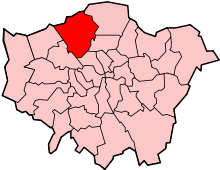
 Barnet shown within Greater London | |||
| Sovereign state | United Kingdom | ||
| Constituent country | England | ||
| Region | London | ||
| Ceremonial county | Greater London | ||
| Status | London borough | ||
| Admin HQ | North London Business Park | ||
| Created | 1 April 1965 | ||
| Government | |||
| • Type | London borough council | ||
| • Body | Barnet London Borough Council | ||
| • Leadership | Leader & Cabinet (Conservative) | ||
| • Mayor | David Longstaff[1] | ||
| • MPs |
Mike Freer (Con) Theresa Villiers (Con) Matthew Offord (Con) | ||
| • London Assembly | Andrew Dismore (Lab) AM for Barnet and Camden | ||
| • EU Parliament | London | ||
| Area | |||
| • Total | 33.49 sq mi (86.74 km2) | ||
| Area rank | 230th (of 326) | ||
| Population (mid-2014 est.) | |||
| • Total | 374,915 | ||
| • Rank | 13th (of 326) | ||
| • Density | 11,000/sq mi (4,300/km2) | ||
| • Ethnicity[2] |
45.5% White British | ||
| • ONS code | 00AC | ||
| Time zone | GMT (UTC0) | ||
| • Summer (DST) | BST (UTC+1) | ||
| Postcodes | EN, HA, N, NW | ||
| Area code(s) | 020 | ||
| Police force | Metropolitan Police | ||
| Website |
www | ||

The London Borough of Barnet (![]() pronunciation ) is a suburban London borough in North London, England, forming part of Outer London. It is the second largest London borough by population with 331,500 inhabitants and covers an area of 86.74 square kilometres (33 sq mi), the fourth highest. It borders Hertfordshire to the north and five other London boroughs: Harrow and Brent to the west, Camden and Haringey to the south-east and Enfield to the east. The borough was formed in 1965 from parts of the counties of Middlesex and Hertfordshire.[3] The local authority is Barnet London Borough Council, based in Hendon.
pronunciation ) is a suburban London borough in North London, England, forming part of Outer London. It is the second largest London borough by population with 331,500 inhabitants and covers an area of 86.74 square kilometres (33 sq mi), the fourth highest. It borders Hertfordshire to the north and five other London boroughs: Harrow and Brent to the west, Camden and Haringey to the south-east and Enfield to the east. The borough was formed in 1965 from parts of the counties of Middlesex and Hertfordshire.[3] The local authority is Barnet London Borough Council, based in Hendon.
History
The borough was formed under the London Government Act 1963 in 1965 from the Municipal Borough of Finchley, Municipal Borough of Hendon and the Friern Barnet Urban District of Middlesex and the East Barnet Urban District and Barnet Urban District of Hertfordshire. The Act did not include a name for the new borough. A joint committee of the councils due to be amalgamated suggested "Northgate" or "Northern Heights".[4] Keith Joseph, the Minister of Housing and Local Government, eventually chose Barnet.[5] The place name Barnet is derived from the Old English bærnet meaning "Land cleared by burning".[6]
The area covered by the modern borough has a long history. Evidence of 1st-century Roman pottery manufacturing has been found at Brockley Hill[7] and Roman coins from the 3rd and 4th centuries were found at Burnt Oak. Both sites are on the Roman road Watling Street from London (Londinium) and St Albans (Verulamium) which now forms the western border of the borough.[8]
Hendon is mentioned in the Domesday Book of 1086,[9] but the districts of Barnet, Edgware and Finchley were not referred to possibly because these areas were included in other manors.[10][11][12]
In 1471 the Battle of Barnet was fought in Monken Hadley, just within the present borough's boundary. It was here that Yorkist troops led by King Edward IV killed the "Kingmaker" Richard Neville, Earl of Warwick and his brother, John Neville, 1st Marquess of Montagu.
Individual articles describe the history and development of the districts of Church End, East Finchley, Edgware, Golders Green and North Finchley.
Governance
Parliamentary constituencies

The residents of London Borough of Barnet are represented at Westminster by Members of Parliament (MPs) for three parliamentary constituencies. All three MPs are Conservative. Chipping Barnet is represented by Theresa Villiers.[13] Finchley and Golders Green is represented by Mike Freer.[14] Hendon, in 2010 the most marginal Conservative-held seat in London with a majority of 106 votes,[15] is represented by Matthew Offord.
Council
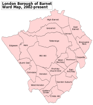
The borough is divided into 21 wards, each with 3 councillors. Following the local government election on 4 May 2006 the Conservative party gained a working majority and full control of the council. Mike Freer became leader of the council on 11 May 2006, replacing Brian Salinger as Conservative group leader, having previously been Salinger's deputy.[16] Barnet had £27.4 million invested in Icelandic banks Glitnir and Landsbanki when they collapsed October 2008.[17] A report showed that Barnet Council failed to follow correct procedures when depositing the money.[18]
The Conservatives retained control at the 2014 local elections, after which the political composition of the council was:[19]
- Conservative: 32 (-6)
- Labour: 30 (+8)
- Liberal Democrat: 1 (-2)
Barnet Council along with the 31 other London boroughs and the City of London Corporation share local government powers with Greater London Authority. The area covered by London Borough of Barnet and the London Borough of Camden is jointly represented in the London Assembly by Andrew Dismore, a Labour politician who was previously the Member of Parliament for Hendon until 2010. Campaigning on parking, he beat Conservative politician Brian Coleman at the 2012 London Assembly election overturning a 20,000 vote deficit and turning this into a 21,000 vote majority.
Service delivery
In 2009, the authority started to introduce a new model of local government delivery in the borough, called 'Future Shape',[20][21] after commissioning a six-month external study.[22] The first stages of 'Future Shape' were agreed by the council's cabinet in July 2009.[23][24][25] The mainly public-sector union UNISON commissioned its own report on the issues involved in 'Future Shape'.[26] The scheme has been dubbed easyCouncil because of its similarity to EasyJet's business model.[27] It was renamed the 'One Barnet Programme' and is referred to as the commissioning council.
Geography
| London Borough of Barnet | ||||||||||||||||||||||||||||||||||||||||||||||||||||||||||||
|---|---|---|---|---|---|---|---|---|---|---|---|---|---|---|---|---|---|---|---|---|---|---|---|---|---|---|---|---|---|---|---|---|---|---|---|---|---|---|---|---|---|---|---|---|---|---|---|---|---|---|---|---|---|---|---|---|---|---|---|---|
| Climate chart (explanation) | ||||||||||||||||||||||||||||||||||||||||||||||||||||||||||||
| ||||||||||||||||||||||||||||||||||||||||||||||||||||||||||||
| ||||||||||||||||||||||||||||||||||||||||||||||||||||||||||||
The borough covers a group of hills on the northern edge of the London Basin. The bedrock is chalk which is covered with clay. Some of the hills are formed from glacial till deposited at the farthest extent of glaciers during the Anglian glaciation.
The pattern of settlement is somewhat diverse.
In the north of the borough on the eastern side is Barnet, also known as High Barnet or Chipping Barnet, Totteridge, and Whetstone. In the north on the western side is Edgware and Mill Hill. The central northern part of the borough is largely countryside. This division is largely because the eastern side grew around what is now the High Barnet Underground branch of the Northern line. The western side grew around the Midland Railway and what is now the Edgware branch of the Northern line. The north is mainly affluent and rural, although it does include Edgware, a major town.
Further south, around the borough's centre, the development becomes steadily more intensive around the suburbs of Cricklewood, Colindale, Hendon and Finchley. Golders Green is renowned for its Jewish minority ethnic population and forms part of the south of the borough, along with Hampstead Garden Suburb and Childs Hill, which are a mix of being affluent like the north, and urban like the central areas.
The A5 (Edgware Road) forms the border between Barnet and the boroughs of Brent and Harrow, with an exception being the West Hendon area and part of the Welsh Harp.
Community facilities
There are 15 council run libraries in the London Borough of Barnet, mobile library and home library services, and a local studies and archives library.[28]
Much of the borough is within the Metropolitan Green Belt, and it has a large number of parks and open spaces. In addition there are large areas taken over by cemeteries and golf courses, and part of Hampstead Heath, Hampstead Heath Extension and Golders Hill Park. Barnet describes its 16 main open spaces as 'premier parks', nine of which achieved a Green Flag Award for 2008/9:[29] The borough has sixty-seven Sites of Importance for Nature Conservation, eight Local Nature Reserves, and it is jointly responsible with the London Borough of Brent for the Welsh Harp (Brent) Reservoir, which is a Site of Special Scientific Interest. These are listed in Nature reserves in Barnet. It is also home to the League Two football team Barnet F.C., whose Underhill ground was previously a council owned ground until 2002.
Landmarks
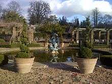
Barnet has two Grade I Listed buildings,[30] both designed by Edwin Lutyens: the Church of St Jude, the parish church of Hampstead Garden Suburb with a Gothic spire and on the opposite side of Central Square, the Free Church, of similar design but with a concrete dome.[3] The Royal Air Force Museum is a museum built on part of the site of Hendon Aerodrome, dedicated to the history of aviation, and the British Royal Air Force in particular.
Church Farmhouse Museum on Greyhound Hill in Hendon is a grade II* listed 17th-century farmhouse used by Barnet Council as an exhibition space and museum until the Council closed to save money on 31 March 2011. Early in 2014 it was given the classification of "vulnerable" by English Heritage after having stood abandoned for almost three years.[31] Friern Hospital was a large Victorian psychiatric hospital located in Friern Barnet, which has been converted into flats.
The Jewish Military Museum is a museum located in Hendon. It features exhibits about Jews serving in the British armed forces from the 18th century to the present day.
Sport
The borough is traditionally home to a professional football club, Barnet F.C. and Non-League football clubs Wingate & Finchley F.C., Hendon F.C. and Edgware Town. Wingate is the last of these with a home ground in the Borough; Hendon and Edgware play in the Borough of Brent, and Barnet FC play in the Borough of Harrow.
Since 2013 rugby union Premiership outfit Saracens have called the borough home, playing matches at Allianz Park at Barnet Copthall which was previously a community sports stadium and is still used in this capacity thanks to Saracens using movable stands for their matches. As well as athletics facilities, the complex also has a swimming pool.
Demographics
| Population | ||
|---|---|---|
| Year | Pop. | ±% |
| 1801 | 6,404 | — |
| 1811 | 7,502 | +17.1% |
| 1821 | 9,578 | +27.7% |
| 1831 | 11,343 | +18.4% |
| 1841 | 12,436 | +9.6% |
| 1851 | 13,232 | +6.4% |
| 1861 | 22,675 | +71.4% |
| 1871 | 32,119 | +41.6% |
| 1881 | 41,563 | +29.4% |
| 1891 | 58,432 | +40.6% |
| 1901 | 84,784 | +45.1% |
| 1911 | 123,023 | +45.1% |
| 1921 | 169,204 | +37.5% |
| 1931 | 232,722 | +37.5% |
| 1941 | 272,356 | +17.0% |
| 1951 | 318,770 | +17.0% |
| 1961 | 311,951 | −2.1% |
| 1971 | 305,338 | −2.1% |
| 1981 | 290,204 | −5.0% |
| 1991 | 299,934 | +3.4% |
| 2001 | 314,561 | +4.9% |
| 2011 | 356,400 | +13.3% |
| Source: A Vision of Britain through time | ||
In 1801, the civil parishes that form the modern borough had a total population of 6,404; and the area was characterised by farming and woodland — with settlement principally around the Great North Road. By 1830, a new turnpike, the Finchley Road was constructed and horse-drawn omnibuses introduced. The population rose dramatically with the arrival of the trams and railways in the middle of 19th century, and new estates were built to house commuters. As industry relocated away from London during the 1960s, the population entered a decline, that has begun to reverse with new housing developments on brownfield sites.
According to the 2001 census the borough then had a population of 314,564[32] though the most recent ONS projection for 2008 is 331,500.[33] 67% of householders are owner-occupiers. 47.3% of people described themselves as Christian, with the second largest group being Jewish at 14.8%, the highest percentage in any local government area in the United Kingdom. The third largest was people who said they had no religion at 12.8%. Just over a quarter of people belonged to non-white ethnic groups, up from 18% in the 1991 census. 12.3% were Asian and 6.0% black. Barnet has the largest Chinese population of any London borough at 6,379.[34]
As of 2011, 13.3% of the borough's population is over 65 - the sixth-highest of London's boroughs. The 65+ population is 47,400, the second-highest after Bromley. The Jewish population is 54,084 and represents 15.5% of the population - the highest in England.[35] 41.2% identify themselves as Christians, and 16.1% with no religion.
Education
The London Borough of Barnet has 86 primary schools, 22 secondary schools and four special schools. Woodhouse College is a single site state sixth form college in North Finchley. The main college in the borough is Barnet College, with five sites.[36] Middlesex University has its main campus at Hendon. University College London has its teaching observatory at Mill Hill.
Economy
Chipping Barnet has been a market town since the thirteenth century, the rest of the area was agricultural. In 1588 Queen Elizabeth I granted a charter to the Lord of the Manor of Barnet to hold a twice yearly horse fair. The first example of an American style out-of-town shopping centre was built at Brent Cross in the 1970s. McDonald's has its UK headquarters at East Finchley.[3] Argonaut Games once had its head office in Edgware.[37]
Transport
Transport policy
Former mayor of London, Ken Livingstone said "Barnet's transport agenda is recklessly anti-public transport, anti-pedestrian and anti-cycling. Barnet has become a laboratory experiment for some very ill-thought out policies".[38] In 2004 cycle lanes were removed and cycle training funding cut by the controversial pro-motorist Cllr Brian Coleman.[39]
Road

The A5 is a major road in that forms much of the borough's western border. It is also the first Roman built road in England. It later took the Anglo-Saxon name Watling Street. The Great North Road passes through the borough starting at East Finchley and crossing into Hertfordshire at Monken Hadley. It was a coaching route used by mail coaches between London, York and Edinburgh. The many inns on the road provided accommodation, stabling for the horses and replacement mounts.[40] A section of the A1 road was built to bypass this route through Mill Hill, eventually joining the Great North Road at Hatfield. The Finchley Road was built as a turnpike in the 1830s linking the West End to Finchley. The A41 splits off from the Finchley Road just before it crosses the borough boundary, briefly merges with the A1 through Mill Hill, leaving the borough at Edgware. The North Circular Road (or A406) is part of an orbit route for London, it crosses the borough East-West linking all the other major routes. Junctions one, two and four of the M1 motorway are in the borough. London Gateway services is at the site of the abandoned third junction. The bus routes in the borough are managed by Transport for London.
Rail
The borough is served by the northern-most sections of the London Underground's Northern line, including all three of the line's northern termini (Edgware, High Barnet, and Mill Hill East). The surface sections of the High Barnet and Edgware branches are entirely in the borough. The High Barnet branch surfaces just before East Finchley station. At Finchley Central station there is a single station spur to Mill Hill East station. The rest of the line continues through West Finchley, Woodside Park and Totteridge and Whetstone stations to the terminus at High Barnet station. The Edgware branch emerges at Golders Green station, the line continues on a series of viaducts through Brent Cross station to Hendon Central station. Here it goes through a tunnel before continuing above ground through Colindale and Burnt Oak stations to the terminus at Edgware Station. The Piccadilly line, although in the Borough of Enfield, is very close to the border, with buses in Barnet connecting people to the stations.
National Rail services in Barnet are operated by First Capital Connect on two routes. The Midland Main Line passes through the western edge of the borough. First Capital Connect operates the Thameslink Route on this line. The Thameslink route runs north to south through London from Bedford to Brighton. The three stations within the borough boundaries on this route north to south are: Mill Hill Broadway, Hendon and Cricklewood. The East Coast Main Line crosses the north-eastern corner of the borough. First Capital Connect operates the Great Northern Route on this line. The three stations in the borough are New Barnet, Oakleigh Park and New Southgate (which straddles the border with the London Borough of Enfield).
There was a railway line joining the two sides of the borough, part of the Edgware, Highgate and London Railway which was going to be part of the Underground's Northern Line "Northern Heights" expansion, but steam passenger services beyond Mill Hill East ended in 1939, and the completion of the electrification of this railway was eventually abandoned in the 1950s, primarily because the full extension would have breached the Town & Country Planning Act of 1947. What track was laid, was removed in the 1960s, with part of the trackbed used for the M1 motorway in the 1970s.
Travel to work
In March 2011, the main forms of transport that residents aged 16–74 used to travel to work were (expressed as percentages of all residents aged 16–74):
| Method of transport | Percentage |
|---|---|
| not in employment | 33.9% |
| driving a car or van | 24.1% |
| underground, metro, light rail, tram | 7.9% |
| bus, minibus or coach | 7.9% |
| work mainly at or from home | 4.9% |
| on foot | 4.1% |
| train | 3.9% |
| passenger in a car or van | 1.4% |
| bicycle | 0.9% |
Public services
Barnet Clinical Commissioning Group commissions NHS services for Barnet residents. Health care providers active within Barnet include the Royal Free London NHS Foundation Trust, which runs Barnet Hospital, Chase Farm Hospital and some clinics at Edgware Community Hospital, and Central London Community Healthcare NHS Trust, which runs Finchley Memorial Hospital and other services at Edgware Community Hospital. The London Ambulance Service responds to medical emergencies in the area. Home Office policing in the borough is provided by the Metropolitan Police Service. There are four police stations in the borough at: Colindale, Barnet, Golders Green and Whetstone. The Peel Centre at Hendon is the Metropolitan Police College.
Statutory emergency fire service is provided by the London Fire Brigade. There are four fire stations that operate in the Borough of Barnet. These are mobilised to protect around 330,000 people. The main risks identified in the borough include Barnet FC's stadium, Underhill Stadium, Brent Cross shopping centre, Coppetts Wood Hospitals and Barnet General Hospital. There are also several busy roads that run through the borough such as the A1 and A406. Between the four stations; five pumping appliances, two equipment lorries, a bulk foam unit, a breathing apparatus support unit, a damage control support unit and a hazardous materials support unit are operated.[42]
International relations
Twin towns — sister cities
 Barnet, Vermont, United States
 Chaville, Hauts-de-Seine, Île-de-France, France
 Jinja, Uganda
- Le Raincy, Seine-Saint-Denis, Île-de-France, France
- Montclair Township, Essex County, New Jersey, United States
 Morphou, Cyprus
 Ramat Gan, Israel[43][44]
 Siegen-Wittgenstein, North Rhine-Westphalia, Germany
- Tempelhof-Schöneberg, Berlin, Germany
See also
References
- ↑ http://www.times-series.co.uk/news/14513060.New_Barnet_Mayor_Councillor_David_Longstaff_is_sworn_into_office/
- ↑ 2011 Census: Ethnic group, local authorities in England and Wales, Office for National Statistics (2012). See Classification of ethnicity in the United Kingdom for the full descriptions used in the 2011 Census.
- 1 2 3 Pevsner, Nikolaus; Bridget Cherry (1999). London 4: North. Penguin Books. pp. 105–192. ISBN 0-14-071049-3.
- ↑ "Where Judgment Of Solomon Will Be Needed Minister To Have Final Word On Names Of New London Boroughs". London: The Times. 8 August 1963. p. 5.
- ↑ "Chelsea Name Retained New Decisions On Three Boroughs". London: The Times. 3 January 1964. p. 5.
- ↑ A. D. Mills, ed. (2003). "Barnet, Chipping". A Dictionary of British Place-Names. Oxford University Press. ISBN 0-19-852758-6.
- ↑ "Brockley Hill". Barnet Council. Retrieved 7 February 2010.
- ↑ "Burnt Oak". Barnet Council. Retrieved 7 February 2010.
- ↑ Baker, T F T (1976). "A History of the County of Middlesex: Volume 5". Victoria County History. Retrieved 20 February 2010.
- ↑ Page, William (1908). "A History of the County of Hertford: volume 2". Victoria County History. Retrieved 20 February 2010.
- ↑ Baker, T F T (1971). "A History of the County of Middlesex: Volume 4". Victoria County History. Retrieved 20 February 2010.
- ↑ Baker, T F T (1980). "A History of the County of Middlesex: Volume 6". Victoria County History. Retrieved 20 February 2010.
- ↑ "Election 2010 Chipping Barnet". BBC News. 7 May 2010. Retrieved 7 May 2010.
- ↑ "Election 2010 Finchley and Golders Green". BBC News. 7 May 2010. Retrieved 7 May 2010.
- ↑ "Election 2010 Hendon". BBC News. 7 May 2010. Retrieved 7 May 2010.
- ↑ Marzouk, Lawrence (18 May 2006). "'Right-wing coup'". Times Series Newspapers. Retrieved 2008-06-03.
- ↑ Lowe, Rebecca (16 October 2008). "BARNET: Held to account over bank crash". Times Series. Retrieved 2009-06-08.
- ↑ Lowe, Rebecca (10 March 2009). "Barnet Council officer resigns over Icelandic bank deposits". Times Series. Retrieved 2009-06-08.
- ↑ "Barnet - Your Councillors". Barnet London Borough Council. 22 May 2014. Archived from the original on 4 March 2016. Retrieved 27 August 2015.
- ↑ London Borough of Barnet Future Shape programme
- ↑ Barnet TUC Archived 5 September 2011 at the Wayback Machine. Response to 'Future Shape' plan
- ↑ Barnet Local Government Chronicle Walkley appointed Barnet chief (February, 2009)
- ↑ London Borough of Barnet Archived 13 August 2011 at the Wayback Machine. 'Future Shape' plan agreed, July 2009
- ↑ London Borough of Barnet Archived 17 April 2010 at the Wayback Machine. 'Future Shape' press release, July 2009
- ↑ Local Government Chronicle 'Barnet's proposals begin to emerge' article
- ↑ European Services Strategy Unit 'Future Shape' report, September 2008
- ↑ Mulholland, Hélène (3 February 2010). "Mr easyCouncil defends his local government model". London: Guardian News and Media Limited. Retrieved 18 February 2010.
- ↑ Local libraries in Barnet accessed 26 July 2007 Archived 17 November 2007 at the Wayback Machine.
- ↑ "Premier parks". Barnet Council. 2008-08-19. Retrieved 2009-06-12.
- ↑ "Statutory Listed Buildings of Barnet" (PDF). Barnet Council. Retrieved 8 February 2010.
- ↑ "Main Menu". Church Farmhouse Museum. Retrieved 5 March 2010.
- ↑ "Information on Barnet (Local Authority)". Office for National Statistics. Retrieved 6 January 2010.
- ↑ "Barnet population estimate: 2008". Barnet Council. 2009. Retrieved 6 January 2010.
- ↑ London Borough of Barnet, Census 2001 Barnet Briefing, Ethnicity, Religion and Place of Birth
- ↑ "Neighbourhood Statistics".
- ↑ "Schools and Colleges". Barnet Council. Retrieved 8 February 2010.
- ↑ "Argonaut Contact information". Argonaut Games. 13 January 1998. Archived from the original on 13 January 1998. Retrieved 9 November 2009. "Argonaut House 369 Burnt Oak Broadway Edgware Middlesex HA8 5XZ"
- ↑ "Humps face-off". Times Series.
- ↑ Webster, Ben (22 March 2004). "Motorists' champion rips out humps and bus lanes". The Times. London. Retrieved 2009-09-28.
- ↑ Norman W. Webster (1974) The Great North Road
- ↑ "2011 Census: QS701EW Method of travel to work, local authorities in England and Wales". Office for National Statistics. Retrieved 23 November 2013. Percentages are of all residents aged 16-74 including those not in employment. Respondents could only pick one mode.
- ↑ London Fire Brigade - Barnet Profile
- ↑ "Ramat Gan Sister Cities". Archived from the original on 7 March 2008. Retrieved 6 April 2008.
- ↑ "Ramat Gan Sister Cities".
Further reading
- Hewlett, Janet; et al. (1997). Nature Conservation in Barnet. London Ecology Unit. ISBN 1 871045 27 4.
External links
| Wikimedia Commons has media related to London Borough of Barnet. |
- Barnet Council web site
- "Parks and open spaces in the Barnet area". London Borough of Barnet. Archived from the original on 29 October 2012.
- Barnet parks and gardens, London Gardens Online
- Barnet Society web site
Coordinates: 51°37′31″N 0°09′10″W / 51.6254°N 0.1527°W