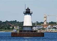
Borden Flats Light
 2008 photo | |
 | |
| Location | Taunton River, Fall River, Massachusetts |
|---|---|
| Coordinates | 41°42′16.986″N 71°10′27.825″W / 41.70471833°N 71.17439583°WCoordinates: 41°42′16.986″N 71°10′27.825″W / 41.70471833°N 71.17439583°W |
| Year first constructed | 1875 |
| Year first lit | 1881 (current tower) |
| Automated | 1963 |
| Foundation | Cast iron and concrete caisson |
| Construction | Cast iron |
| Tower shape | Conical |
| Markings / pattern | Brown caisson, white body, black lantern |
| Height | 48 feet (15 m) |
| Focal height | 47 feet (14 m) |
| Original lens | 4th order Fresnel lens |
| Current lens | 250 millimetres (9.8 in) |
| Range | 11 nautical miles (20 km; 13 mi) |
| Characteristic |
Original: Fixed red Current: Flash white 2.5s |
| Fog signal |
Until 1983: Bell Current: Horn: 1 every 10s |
| Admiralty number | J0576 |
| ARLHS number | USA-072 |
| USCG number | |
|
Borden Flats Light Station | |
| Area | 0.1 acres (0.040 ha) |
| Built | 1881 |
| MPS | Lighthouses of Massachusetts TR |
| NRHP Reference # | 87001528[1][4][5] |
| Added to NRHP | June 15, 1987 |
Borden Flats Light is a historic lighthouse on the Taunton River in Fall River, Massachusetts. It is a tower-on-caisson type known as a sparkplug lighthouse.
The light was built in 1881, and added to the National Register of Historic Places as Borden Flats Light Station on June 15, 1987, reference number 87001528.
History
By the mid-19th century, the city of Fall River had become a bustling textile-mill town, with regularly scheduled steamboat service to Providence, Rhode Island and New York City. The city is located at the mouth of the Taunton River where it meets Mount Hope Bay, which is an arm of Narragansett Bay.
Prior to the lighthouse, an unlit day beacon was constructed to mark the spot of a dangerous reef near the center of the relatively shallow Mount Hope Bay. In June 1880, $25,000 was appropriated for the construction of a new lighthouse on Borden Flats, which consisted of a 50-foot-tall (15 m) cast-iron tower that included a keeper's quarters. The light went into service on October 1, 1881, with a fourth-order Fresnel lens producing a fixed red light 47-foot (14 m) above mean high water. Rainwater was collected in gutters and stored in a cistern in the structure's basement level, providing the keeper's water supply.
The lighthouse, which sits in water open to the south, was battered in the hurricane of 1938. The storm left the structure with a pronounced tilt, which it still has. A new wider caisson was later added around the original one for additional protection.
In 1957 the lighthouse was electrified. It was automated in 1963. In 1977, its Fresnel lens was removed and replaced with a modern Vega VRB-25 lens. The fog bell remained in use until 1983 when it was replaced by an electronic foghorn. Under auspices of the National Historic Lighthouse Preservation Act of 2000, the lighthouse was auctioned privately through the General Services Administration. Nick Korstad, Cindy Korstad and Craig Korstad, of Portland, Oregon are the new owners. They have plans of fully restoring the light station and making it available for public tours and overnight accommodations.[6]
Gallery
|

See also
References
- 1 2 Light List, Volume I, Atlantic Coast, St. Croix River, Maine to Shrewsbury River, New Jersey (PDF). Light List. United States Coast Guard. 2009. p. 172.
- ↑ "Historic Light Station Information and Photography: Massachusetts". United States Coast Guard Historian's Office.
- ↑ Rowlett, Russ (2009-09-15). "Lighthouses of the United States: Southeast Massachusetts". The Lighthouse Directory. University of North Carolina at Chapel Hill.
- ↑ National Park Service (2009-03-13). "National Register Information System". National Register of Historic Places. National Park Service.
- ↑ The coordinates shown are the official coordinates from the cited Light List and are shown to the precision given there.
- ↑ "New England Lighthouses: A Virtual Guide: Borden Flats Light". Jeremy D'Entremont. 2009-09-15.
| Topics |  | ||||||||||||||||||||||||||||||
|---|---|---|---|---|---|---|---|---|---|---|---|---|---|---|---|---|---|---|---|---|---|---|---|---|---|---|---|---|---|---|---|
| Lists by county | |||||||||||||||||||||||||||||||
| Lists by city |
| ||||||||||||||||||||||||||||||
| Other lists | |||||||||||||||||||||||||||||||
| |||||||||||||||||||||||||||||||