| [4] |
Name on the Register[2] |
Image |
Date listed[5] |
Location |
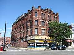
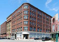
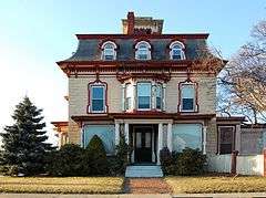
Description |
|---|
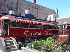
| 1 |
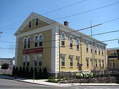
Capitol Diner |
|
000000001999-09-22-0000September 22, 1999
(#99001121) |
431 Union St.
42°27′47″N 70°56′41″W / 42.463056°N 70.944722°W / 42.463056; -70.944722 (Capitol Diner) |
part of the Diners of Massachusetts Multiple Property Submission (MPS)
|
| 2 |
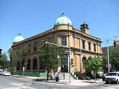
Central Square Historic District |
|
000000001985-12-10-0000December 10, 1985
(#85003335) |
Central Sq., Monroe, Union, and Willow Sts.
42°27′50″N 70°56′44″W / 42.463889°N 70.945556°W / 42.463889; -70.945556 (Central Square Historic District) |
|
| 3 |
Diamond Historic District |
|
000000001996-10-10-0000October 10, 1996
(#96001040) |
Roughly bounded by Broad, Lewis, Ocean Sts., Swampscott Line, Lynn Shore Dr., and Wave and Nahant Sts.
42°27′38″N 70°55′58″W / 42.460556°N 70.932778°W / 42.460556; -70.932778 (Diamond Historic District) |
|
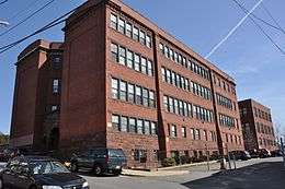
| 4 |
English High School |
|
000000001986-09-11-0000September 11, 1986
(#86002508) |
498 Essex St.
42°27′59″N 70°56′50″W / 42.4664°N 70.9471°W / 42.4664; -70.9471 (English High School) |
Listing is for the 1890s former building, not the current facilities.
|
| 5 |
Fabens Building |
|
000000001982-02-25-0000February 25, 1982
(#82001879) |
312-314 Union St.
42°27′53″N 70°56′38″W / 42.464722°N 70.943889°W / 42.464722; -70.943889 (Fabens Building) |
|
| 6 |
G.A.R. Hall and Museum |
|
000000001979-05-07-0000May 7, 1979
(#79000331) |
58 Andrew St.
42°27′46″N 70°56′53″W / 42.462778°N 70.948056°W / 42.462778; -70.948056 (G.A.R. Hall and Museum) |
|
| 7 |
High Rock Tower-High Rock Cottage and Daisy Cottage |
|
000000001979-10-11-0000October 11, 1979
(#09000086) |
15, 17 Campbell Terr. and High Rock Park
42°28′06″N 70°56′49″W / 42.468441°N 70.947007°W / 42.468441; -70.947007 (High Rock Tower-High Rock Cottage and Daisy Cottage) |
|
| 8 |
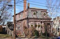
Charles Lovejoy House |
|
000000001978-11-28-0000November 28, 1978
(#78000454) |
64 Broad St.
42°27′48″N 70°56′19″W / 42.463333°N 70.938611°W / 42.463333; -70.938611 (Charles Lovejoy House) |
|
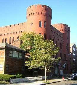
| 9 |
Lynn Armory |
|
000000001979-09-07-0000September 7, 1979
(#79000332) |
36 S. Common St.
42°27′47″N 70°57′16″W / 42.463056°N 70.954444°W / 42.463056; -70.954444 (Lynn Armory) |
|
| 10 |
Lynn Bank Block |
|
000000001982-08-26-0000August 26, 1982
(#82004964) |
21-29 Exchange St.
42°27′49″N 70°56′36″W / 42.463583°N 70.943306°W / 42.463583; -70.943306 (Lynn Bank Block) |
|
| 11 |
Lynn Common Historic District |
|
000000001992-04-10-0000April 10, 1992
(#92000247) |
Roughly N. and S. Common St. from Market Sq. to City Hall
42°27′49″N 70°57′28″W / 42.463611°N 70.957778°W / 42.463611; -70.957778 (Lynn Common Historic District) |
|
| 12 |
Lynn Masonic Hall |
|
000000001979-08-21-0000August 21, 1979
(#79000333) |
64-68 Market St.
42°27′48″N 70°56′59″W / 42.463333°N 70.949722°W / 42.463333; -70.949722 (Lynn Masonic Hall) |
|
| 13 |
Lynn Memorial City Hall and Auditorium |
|
000000002005-02-24-0000February 24, 2005
(#05000082) |
3 City Hall Square
42°27′53″N 70°57′06″W / 42.464722°N 70.951667°W / 42.464722; -70.951667 (Lynn Memorial City Hall and Auditorium) |
|
| 14 |
Lynn Public Library |
|
000000001979-08-21-0000August 21, 1979
(#79000334) |
5 N. Common St.
42°27′52″N 70°57′15″W / 42.464444°N 70.954167°W / 42.464444; -70.954167 (Lynn Public Library) |
|
| 15 |
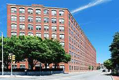
Lynn Realty Company Building No. 2 |
|
000000001983-03-31-0000March 31, 1983
(#83000579) |
672-680 Washington St.
42°27′43″N 70°56′41″W / 42.461944°N 70.944722°W / 42.461944; -70.944722 (Lynn Realty Company Building No. 2) |
|
| 16 |
Lynn Woods Historic District |
|
000000001996-09-06-0000September 6, 1996
(#96000951) |
Roughly bounded by Lynnfield St., Bow Ridge, Great Woods Rd., Parkland Ave., Walnut St., Saugus Line
42°29′21″N 70°59′13″W / 42.489167°N 70.986944°W / 42.489167; -70.986944 (Lynn Woods Historic District) |
|
| 17 |
Mowers' Block |
|
000000001982-02-25-0000February 25, 1982
(#82001991) |
7 Willow St. and 67-83 Blake St.
42°27′51″N 70°56′44″W / 42.4642°N 70.9456°W / 42.4642; -70.9456 (Mowers' Block) |
|
| 18 |
Munroe Street Historic District |
|
000000001996-12-02-0000December 2, 1996
(#96000952) |
Bounded by Market, Oxford, and Washington Sts., and the MBTA commuter rail line
42°27′46″N 70°56′53″W / 42.4628°N 70.9481°W / 42.4628; -70.9481 (Munroe Street Historic District) |
|
| 19 |
Nahant Beach Boulevard-Metropolitan Park System of Greater Boston |
|
000000002003-08-11-0000August 11, 2003
(#03000747) |
Nahant Beach Boulevard
42°26′12″N 70°56′17″W / 42.4367°N 70.9381°W / 42.4367; -70.9381 (Nahant Beach Boulevard-Metropolitan Park System of Greater Boston) |
Extends for most of its length into Nahant. Part of the Metropolitan Park System of Greater Boston MPS.
|
| 20 |
Lucian Newhall House |
|
000000001985-07-18-0000July 18, 1985
(#85001576) |
281 Ocean St.
42°27′39″N 70°56′12″W / 42.4608°N 70.9367°W / 42.4608; -70.9367 (Lucian Newhall House) |
|
| 21 |
Old Lynn High School |
|
000000002002-03-06-0000March 6, 2002
(#02000130) |
50 High St.
42°27′58″N 70°56′45″W / 42.4662°N 70.9459°W / 42.4662; -70.9459 (Old Lynn High School) |
|
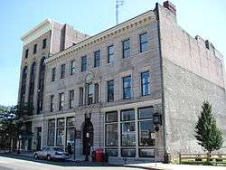
| 22 |
Old Post Office Building |
|
000000001981-09-14-0000September 14, 1981
(#81000118) |
360 Washington St.
42°27′53″N 70°56′54″W / 42.4647°N 70.9483°W / 42.4647; -70.9483 (Old Post Office Building) |
|
| 23 |
Pine Grove Cemetery |
|
000000002014-06-27-0000June 27, 2014
(#14000364) |
145 Boston St.
42°28′39″N 70°57′44″W / 42.4774°N 70.9621°W / 42.4774; -70.9621 (Pine Grove Cemetery) |
|
| 24 |
Lydia Pinkham House |
|
000000002012-09-25-0000September 25, 2012
(#12000818) |
285 Western Ave.
42°28′33″N 70°57′03″W / 42.4757°N 70.9507°W / 42.4757; -70.9507 (Lydia Pinkham House) |
Pinkham's home was the mailing address for orders of her homemade herbal remedy for menstrual cramps, one of the most popular such medications of the late 19th century, as a result of her then-innovative use of her image as a marketing tool.
|
| 25 |
St. Stephen's Memorial Church |
|
000000001979-09-07-0000September 7, 1979
(#79000335) |
74 S. Common St.
42°27′46″N 70°57′24″W / 42.462778°N 70.956667°W / 42.462778; -70.956667 (St. Stephen's Memorial Church) |
|
| 26 |
Tapley Building |
Upload image |
000000001983-03-31-0000March 31, 1983
(#83000586) |
206 Broad St.
42°27′45″N 70°56′41″W / 42.4625°N 70.944722°W / 42.4625; -70.944722 (Tapley Building) |
Destroyed by fire in 1999.
|
| 27 |
US Post Office-Lynn Main |
|
000000001986-06-20-0000June 20, 1986
(#86001342) |
51 Willow St.
42°27′54″N 70°56′48″W / 42.465°N 70.946667°W / 42.465; -70.946667 (US Post Office-Lynn Main) |
|
| 28 |
Vamp Building |
|
000000001983-03-31-0000March 31, 1983
(#83000587) |
3-15 Liberty Square
42°27′45″N 70°56′50″W / 42.4625°N 70.947222°W / 42.4625; -70.947222 (Vamp Building) |
|