Sandy Neck Light
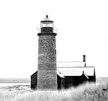 US Coast Guard photo | |
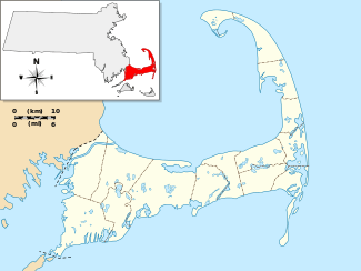 | |
| Location | Barnstable, Massachusetts |
|---|---|
| Coordinates | 41°43′22″N 70°16′52″W / 41.72278°N 70.28111°WCoordinates: 41°43′22″N 70°16′52″W / 41.72278°N 70.28111°W |
| Year first constructed | 1826 |
| Year first lit | 1857 (current structure) |
| Deactivated | 1931-2007 |
| Tower shape | Cylindrical Stone Tower |
| Markings / pattern | White with black bands and lantern |
| Original lens | 5th order Fresnel lens |
| Range | 4 nautical miles (7.4 km; 4.6 mi) |
| Characteristic | Fl W 6s |
| Fog signal | none |
| USCG number | 1-13117[1][2] |
Sandy Neck Light was first established in 1826. The current tower was built in 1857 and strengthened in the 1880s. It was discontinued in 1931, replaced by a skeleton tower, which was discontinued in 1952. The light was relit as a private aid to navigation in 2007.[3]
References
- ↑ "Historic Light Station Information and Photography: Massachusetts". United States Coast Guard Historian's Office. 2009-09-02.
- ↑ United States Coast Guard (2009). Light List, Volume I, Atlantic Coast, St. Croix River, Maine to Shrewsbury River, New Jersey. p. 108.
- ↑ Rowlett, Russ (2009-08-06). "Lighthouses of the United States: Southeast Massachusetts". The Lighthouse Directory. University of North Carolina at Chapel Hill.
This article is issued from Wikipedia - version of the 8/13/2015. The text is available under the Creative Commons Attribution/Share Alike but additional terms may apply for the media files.