Bibb County, Alabama
| Bibb County, Alabama | |
|---|---|
 | |
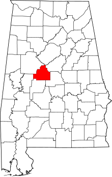 Location in the U.S. state of Alabama | |
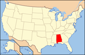 Alabama's location in the U.S. | |
| Founded | February 7, 1818 |
| Named for | William W. Bibb |
| Seat | Centreville |
| Largest city | Brent |
| Area | |
| • Total | 626 sq mi (1,621 km2) |
| • Land | 623 sq mi (1,614 km2) |
| • Water | 3.6 sq mi (9 km2), 0.6% |
| Population (est.) | |
| • (2015) | 22,583 |
| • Density | 37/sq mi (14/km²) |
| Congressional district | 6th |
| Time zone | Central: UTC-6/-5 |
| Website |
www |
|
Footnotes:
| |
Bibb County is a county in the U.S. state of Alabama. As of the 23rd Decennial 2010 United States Census its population was 22,915.[1] The county seat is Centreville.[2] Its name is in honor of William W. Bibb, (1781-1820), the Governor of Alabama Territory, (1817-1819), and the first Governor of Alabama, (1819-1820, when he died), who is also the namesake for Bibb County, Georgia where he began his political career. It is a "prohibition" or dry county; however, the cities of West Blocton, Brent, and Centreville have all become "wet", by allowing the sale of alcoholic beverages.[3]
The Bibb County Courthouse is located in the county seat of Centreville.
History
Cahawba County was established ("erected") on February 7, 1818, named for the Cahawba River, (now more commonly spelled as Cahaba River). This name came from the Choctaw language word meaning "water above." On December 4, 1820, it was renamed as Bibb County.[4]
With a large population of slaves before the American Civil War, during and after Reconstruction whites worked to dominate and establish white supremacy. In addition to laws that the state legislature passed, creating a new constitution that raised barriers to voter registration and excluding freedmen from the political process, this county ranked with two others: Dallas and Pickens, as having the third-highest number of lynchings in the state. These extra-judicial murders were a form of racial terrorism by the whites against blacks.[5]
Geography
According to the U.S. Census Bureau, the county has a total area of 626 square miles (1,620 km2), of which 623 square miles (1,610 km2) is land and 3.6 square miles (9.3 km2) (0.6%) is water.[6]
Adjacent counties
- Jefferson County - north
- Shelby County - northeast
- Chilton County - southeast
- Perry County - southwest
- Hale County - southwest
- Tuscaloosa County - northwest
National protected areas
Transportation
Major highways
 U.S. Highway 11
 U.S. Highway 82
 State Route 5
 State Route 25
 State Route 58
 State Route 139
 State Route 209
 State Route 219
Rail
Demographics
From 1920 to 1970, the population of the rural county declined considerably. Many African Americans joined the Great Migration to northern and western cities, to escape the violence and racial oppression of Jim Crow.
| Historical population | |||
|---|---|---|---|
| Census | Pop. | %± | |
| 1820 | 3,676 | — | |
| 1830 | 6,306 | 71.5% | |
| 1840 | 8,284 | 31.4% | |
| 1850 | 9,969 | 20.3% | |
| 1860 | 11,894 | 19.3% | |
| 1870 | 7,469 | −37.2% | |
| 1880 | 9,487 | 27.0% | |
| 1890 | 13,824 | 45.7% | |
| 1900 | 18,498 | 33.8% | |
| 1910 | 22,791 | 23.2% | |
| 1920 | 23,144 | 1.5% | |
| 1930 | 20,780 | −10.2% | |
| 1940 | 20,155 | −3.0% | |
| 1950 | 17,987 | −10.8% | |
| 1960 | 14,357 | −20.2% | |
| 1970 | 13,812 | −3.8% | |
| 1980 | 15,723 | 13.8% | |
| 1990 | 16,576 | 5.4% | |
| 2000 | 20,826 | 25.6% | |
| 2010 | 22,915 | 10.0% | |
| Est. 2015 | 22,583 | [7] | −1.4% |
| U.S. Decennial Census[8] 1790–1960[9] 1900–1990[10] 1990–2000[11] 2010–2015[1] | |||
As of the census[12] of 2010, there were 22,915 people, 7,953 households, and 5,748 families residing in the county. The population density was 37 people per square mile (14/km2). There were 8,981 housing units at an average density of 14.3 per square mile (5.5/km2). The racial makeup of the county was 75.8% White, 22.0% Black or African American, 0.3% Native American, 0.1% Asian, 0.1% Pacific Islander, 0.8% from other races, and 0.9% from two or more races. 1.8% of the population were Hispanic or Latino of any race.
There were 7,953 households out of which 29.5% had children under the age of 18 living with them, 52.5% were married couples living together, 14.4% had a female householder with no husband present, and 27.7% were non-families. 24.5% of all households were made up of individuals and 9.40% had someone living alone who was 65 years of age or older. The average household size was 2.60 and the average family size was 3.09.
In the county the population was spread out with 22.7% under the age of 18, 9.0% from 18 to 24, 28.9% from 25 to 44, 26.7% from 45 to 64, and 12.7% who were 65 years of age or older. The median age was 37.8 years. For every 100 females there were 115.9 males. For every 100 females age 18 and over, there were 127.5 males.
The median income for a household in the county was $41,770, and the median income for a family was $51,956. Males had a median income of $40,219 versus $28,085 for females. The per capita income for the county was $19,918. About 9.4% of families and 12.6% of the population were below the poverty line, including 18.4% of those under age 18 and 11.3% of those age 65 or over.
Government and infrastructure
| Year | GOP | DNC | Others |
|---|---|---|---|
| 2016 | 76.4% 6,733 | 21.3% 1,874 | 2.3% 207 |
| 2012 | 73.1% 6,131 | 26.2% 2,200 | 0.7% 60 |
| 2008 | 72.4% 6,262 | 26.6% 2,299 | 1.0% 83 |
| 2004 | 72.0% 5,472 | 27.5% 2,089 | 0.5% 39 |
| 2000 | 60.2% 4,273 | 38.2% 2,710 | 1.6% 118 |
Bibb County has a five-member County Commission, elected from single-member districts. Members take turns in serving as chairman of the commission, rotating the position every nine and a half months.[14]
Alabama Department of Corrections operates the Bibb Correctional Facility in Brent.[15]
Communities
Cities
- Brent
- Centreville (county seat)
Towns
- Vance (part - Part lies in Tuscaloosa County)
- West Blocton
- Woodstock (Part lies in Tuscaloosa County)
Unincorporated communities
Ghost towns
Places of interest
Bibb County is home to the Talladega National Forest supervised by the United States Forestry Service (of the U.S. Department of Agriculture), and a section of the Cahaba River which draws visitors to view the unique "Cahaba Lily", or (known by its scientific Latinized name: Hymenocallis coronaria).
See also
- National Register of Historic Places listings in Bibb County, Alabama
- Properties on the Alabama Register of Landmarks and Heritage in Bibb County, Alabama
References
- 1 2 "State & County QuickFacts". United States Census Bureau. Retrieved May 15, 2014.
- ↑ "Find a County". National Association of Counties. Archived from the original on May 10, 2015. Retrieved 2011-06-07.
- ↑ "Wet and Dry Counties of Alabama". Alcoholic Beverage Control Board. State of Alabama. Archived from the original on September 27, 2011. Retrieved July 27, 2011.
- ↑ "Alabama Counties: Bibb County". Alabama Department of Archives and History. Montgomery, AL: Alabama Department of Archives and History. 2011-12-13. Retrieved 2012-04-30.
- ↑ "Supplement: Lynchings by County/ Alabama: Bibb", 2nd edition, from Lynching in America: Confronting the Legacy of Racial Terror, 2015, Equal Justice Institute, Montgomery, Alabama
- ↑ "2010 Census Gazetteer Files". United States Census Bureau. August 22, 2012. Retrieved August 22, 2015.
- ↑ "County Totals Dataset: Population, Population Change and Estimated Components of Population Change: April 1, 2010 to July 1, 2015". Retrieved July 2, 2016.
- ↑ "U.S. Decennial Census". United States Census Bureau. Archived from the original on May 11, 2015. Retrieved August 22, 2015.
- ↑ "Historical Census Browser". University of Virginia Library. Retrieved August 22, 2015.
- ↑ Forstall, Richard L., ed. (March 24, 1995). "Population of Counties by Decennial Census: 1900 to 1990". United States Census Bureau. Retrieved August 22, 2015.
- ↑ "Census 2000 PHC-T-4. Ranking Tables for Counties: 1990 and 2000" (PDF). United States Census Bureau. April 2, 2001. Retrieved August 22, 2015.
- ↑ "American FactFinder". United States Census Bureau. Archived from the original on 2013-09-11. Retrieved 2015-07-08.
- ↑ "Dave Leip's Atlas of U.S. Presidential Elections". Retrieved November 15, 2016.
- ↑ "County Commission", Bibb County, Alabama website
- ↑ "Bibb Correctional Facility." Alabama Department of Corrections. Retrieved on July 4, 2011.
External links
 |
Tuscaloosa County | Jefferson County | Shelby County | |
| |
||||
| ||||
| | ||||
| Perry County and Hale County | Chilton County |
Municipalities and communities of Bibb County, Alabama, United States | ||
|---|---|---|
| Cities | | |
| Towns | ||
| Unincorporated communities | ||
| Ghost town | ||
| Footnotes | ‡This populated place also has portions in an adjacent county or counties | |
Coordinates: 32°59′52″N 87°07′35″W / 32.99778°N 87.12639°W