Lamar County, Alabama
| Lamar County, Alabama | |
|---|---|
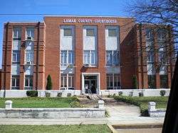 Lamar County Courthouse in Vernon | |
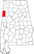 Location in the U.S. state of Alabama | |
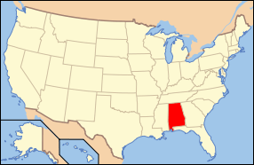 Alabama's location in the U.S. | |
| Founded | February 8, 1877 |
| Named for | Lucius Quintus Cincinnatus Lamar |
| Seat | Vernon |
| Largest city | Vernon |
| Area | |
| • Total | 605 sq mi (1,567 km2) |
| • Land | 605 sq mi (1,567 km2) |
| • Water | 0.6 sq mi (2 km2), 0.1% |
| Population (est.) | |
| • (2015) | 13,886 |
| • Density | 24/sq mi (9/km²) |
| Congressional district | 4th |
| Time zone | Central: UTC-6/-5 |
|
Footnotes:
| |
Lamar County (formerly Jones County and Sanford County) is a county of the U.S. state of Alabama. As of the 2010 census, the population was 14,564.[1] Its county seat is Vernon and is a prohibition or dry county.[2] Its name is in honor of Lucius Quintus Cincinnatus Lamar, member of the United States Senate from Mississippi.[3]
History
Jones County, Alabama was established on February 4, 1867, with land taken from the southern part of Marion County and the western part of Fayette County, and it was named for E. P. Jones of Fayette County, with its county seat at Vernon. This county was abolished on November 13, 1867. On October 8, 1868, the area was again organized into a county, but as Covington County had been renamed "Jones County" the same year (a change that lasted only a few months),[4] the new county was named Sanford, in honor of H. C. Sanford of Cherokee County. On February 8, 1877, the county was renamed Lamar in honor of Senator L.Q.C. Lamar of Mississippi.
Geography
According to the U.S. Census Bureau, the county has a total area of 605 square miles (1,570 km2), of which 605 square miles (1,570 km2) is land and 0.6 square miles (1.6 km2) (0.1%) is water.[5]
Adjacent counties
- Marion County (north)
- Fayette County (east)
- Pickens County (south)
- Lowndes County, Mississippi (southwest)
- Monroe County, Mississippi (west)
Cemeteries
- Blooming Grove Baptist Church Cemetery
- Christian Chapel Church of Christ Cemetery
- Fellowship Baptist Church Cemetery
- Furnace Hill Cemetery
- Kennedy Town Cemetery
- Liberty Baptist Church Cemetery
- Macedonia Baptist Church Cemetery
- Meadow Branch Baptist Church Cemetery
- Mount Olive Church of Christ Cemetery
- Old Mount Nebo Cemetery
- Shiloh (Pinhook) United Methodist Church Cemetery
- Sulligent City Cemetery
- Vernon City Cemetery
- Providence United Methodist Cemetery
- Union Chapel Church Cemetery near Crossville
- Morton Chapel Methodist Church Cemetery near Vernon
- Fairview Church Cemetery
- Lebanon United Methodist Church Cemetery
- Shiloh Baptist Church Cemetery
- Old Liberty Church Cemetery
- South Carolina Church Cemetery near Hightogy
- Springhill Cemetery near Millport
- Wesley Chapel Cemetery
Demographics
| Historical population | |||
|---|---|---|---|
| Census | Pop. | %± | |
| 1870 | 8,893 | — | |
| 1880 | 12,142 | 36.5% | |
| 1890 | 14,187 | 16.8% | |
| 1900 | 16,084 | 13.4% | |
| 1910 | 17,487 | 8.7% | |
| 1920 | 18,149 | 3.8% | |
| 1930 | 18,001 | −0.8% | |
| 1940 | 19,708 | 9.5% | |
| 1950 | 16,441 | −16.6% | |
| 1960 | 14,271 | −13.2% | |
| 1970 | 14,335 | 0.4% | |
| 1980 | 16,453 | 14.8% | |
| 1990 | 15,715 | −4.5% | |
| 2000 | 15,904 | 1.2% | |
| 2010 | 14,564 | −8.4% | |
| Est. 2015 | 13,886 | [6] | −4.7% |
| U.S. Decennial Census[7] 1790–1960[8] 1900–1990[9] 1990–2000[10] 2010–2015[1] | |||
As of the census[11] of 2000, there were 15,904 people, 6,468 households, and 4,715 families residing in the county. The population density was 26 people per square mile (10/km2). There were 7,517 housing units at an average density of 12 per square mile (5/km2). The racial makeup of the county was 86.87% White, 11.98% Black or African American, 0.11% Native American, 0.06% Asian, 0.46% from other races, and 0.51% from two or more races. 1.30% of the population were Hispanic or Latino of any race.
There were 6,468 households out of which 31.40% had children under the age of 18 living with them, 58.60% were married couples living together, 10.90% had a female householder with no husband present, and 27.10% were non-families. 25.40% of all households were made up of individuals and 12.10% had someone living alone who was 65 years of age or older. The average household size was 2.43 and the average family size was 2.89.
In the county the population was spread out with 23.60% under the age of 18, 8.70% from 18 to 24, 27.70% from 25 to 44, 24.10% from 45 to 64, and 15.90% who were 65 years of age or older. The median age was 38 years. For every 100 females there were 93.40 males. For every 100 females age 18 and over, there were 90.90 males.
The median income for a household in the county was $28,059, and the median income for a family was $33,050. Males had a median income of $30,453 versus $18,947 for females. The per capita income for the county was $14,435. About 13.30% of families and 16.10% of the population were below the poverty line, including 19.10% of those under age 18 and 18.60% of those age 65 or over.
2010 census
As of the census[12] of 2010, there were 14,564 people, 6,103 households, and 4,207 families residing in the county. The population density was 24 people per square mile (9/km2). There were 7,354 housing units at an average density of 12 per square mile (5/km2). The racial makeup of the county was 86.7% White, 11.3% Black or African American, 0.2% Native American, 0.0% Asian, 0.6% from other races, and 1.3% from two or more races. 1.2% of the population were Hispanic or Latino of any race.
There were 6,103 households out of which 26.1% had children under the age of 18 living with them, 53.2% were married couples living together, 11.6% had a female householder with no husband present, and 31.1% were non-families. 28.8% of all households were made up of individuals and 13.3% had someone living alone who was 65 years of age or older. The average household size was 2.35 and the average family size was 2.8.
In the county the population was spread out with 22.2% under the age of 18, 7.2% from 18 to 24, 22.5% from 25 to 44, 29.3% from 45 to 64, and 18.8% who were 65 years of age or older. The median age was 43.5 years. For every 100 females there were 95.0 males. For every 100 females age 18 and over, there were 99.4 males.
The median income for a household in the county was $33,887, and the median income for a family was $42,492. Males had a median income of $36,833 versus $25,125 for females. The per capita income for the county was $19,789. About 13.2% of families and 18.5% of the population were below the poverty line, including 25.2% of those under age 18 and 14.6% of those age 65 or over.
Media
Newspapers
- The Vernon Pioneer - (1875–1878) The first newspaper published in Lamar County was The Vernon Pioneer. The Editors and Proprietors included William R. Smith, William R. Smith Jr., Smith, McCullough & Co, Sid B. Smith, and Don R. Aldridge.
- The Vernon Clipper - (1879–1880) - Alexander Cobb as Editor and Proprietor and later Alex A. Wall as Proprietor.
- The Lamar News - (1886–1887) - E. J. McNatt as Editor and Proprietor
- The Sulligent Lightning
- The Vernon Courier - (1886–1890) - Alex A. Wall as Editor and Publisher, then Courier Publishing Co. (R. J. Young as Editor-in-Chief and Mollie C. Young as partner)
- The Eagle-Eye (1894)
- The Lamar Democrat (1901–present)
- The Rural Educator (1908)
- The Sulligent News (1942–1952)
Transportation
Major highways
Rail
Government
| Year | GOP | DNC | Others |
|---|---|---|---|
| 2016 | 83.6% 5,819 | 14.9% 1,035 | 1.5% 107 |
| 2012 | 76.2% 5,453 | 22.9% 1,643 | 0.9% 63 |
| 2008 | 76.6% 5,419 | 22.8% 1,614 | 0.6% 42 |
| 2004 | 71.1% 4,894 | 28.4% 1,956 | 0.5% 35 |
| 2000 | 61.7% 4,470 | 36.6% 2,653 | 1.7% 126 |
Communities
Cities
Towns
Unincorporated communities
See also
- National Register of Historic Places listings in Lamar County, Alabama
- Properties on the Alabama Register of Landmarks and Heritage in Lamar County, Alabama
References
- 1 2 "State & County QuickFacts". United States Census Bureau. Retrieved May 16, 2014.
- ↑ "Find a County". National Association of Counties. Retrieved 2011-06-07.
- ↑ Gannett, Henry (1905). The Origin of Certain Place Names in the United States. Government Printing Office. p. 180.
- ↑ "Alabama Counties: Covington County". Alabama Counties: Covington County. Alabama Department of Archives and History.
- ↑ "2010 Census Gazetteer Files". United States Census Bureau. August 22, 2012. Retrieved August 22, 2015.
- ↑ "County Totals Dataset: Population, Population Change and Estimated Components of Population Change: April 1, 2010 to July 1, 2015". Retrieved July 2, 2016.
- ↑ "U.S. Decennial Census". United States Census Bureau. Retrieved August 22, 2015.
- ↑ "Historical Census Browser". University of Virginia Library. Retrieved August 22, 2015.
- ↑ Forstall, Richard L., ed. (March 24, 1995). "Population of Counties by Decennial Census: 1900 to 1990". United States Census Bureau. Retrieved August 22, 2015.
- ↑ "Census 2000 PHC-T-4. Ranking Tables for Counties: 1990 and 2000" (PDF). United States Census Bureau. April 2, 2001. Retrieved August 22, 2015.
- ↑ "American FactFinder". United States Census Bureau. Retrieved 2011-05-14.
- ↑ "American FactFinder". United States Census Bureau. Retrieved 2015-07-29.
- ↑ "Dave Leip's Atlas of U.S. Presidential Elections". Retrieved November 21, 2016.
External links
 |
Marion County | | ||
| Monroe County, Mississippi | |
Fayette County | ||
| ||||
| | ||||
| Lowndes County, Mississippi | Pickens County |
Municipalities and communities of Lamar County, Alabama, United States | ||
|---|---|---|
| Cities | | |
| Towns | ||
| Unincorporated community | ||
Coordinates: 33°46′50″N 88°05′47″W / 33.78056°N 88.09639°W