Limestone County, Alabama
| Limestone County, Alabama | |
|---|---|
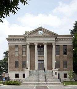 Limestone County Courthouse in Athens | |
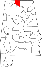 Location in the U.S. state of Alabama | |
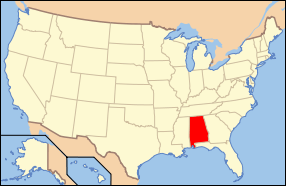 Alabama's location in the U.S. | |
| Founded | February 6[1], 1818[1] |
| Named for | Limestone Creek |
| Seat | Athens |
| Largest city | Athens |
| Area | |
| • Total | 607 sq mi (1,572 km2) |
| • Land | 560 sq mi (1,450 km2) |
| • Water | 47 sq mi (122 km2), 7.8% |
| Population (est.) | |
| • (2015) | 91,663 |
| • Density | 162/sq mi (63/km²) |
| Congressional district | 5th |
| Time zone | Central: UTC-6/-5 |
| Website |
limestonecounty-al |
|
Footnotes:
| |
Limestone County is a county of the U.S. state of Alabama. As of the 2010 census, the county's population was 82,782.[2] Its county seat is Athens.[3] Its name comes from Limestone Creek, a local stream.
Limestone County is included in the Huntsville, AL Metropolitan Statistical Area.
History
Limestone County was established by the Alabama Territorial legislature on February 6, 1818.[1] On November 27, 1821, the Alabama State legislature passed an Act that altered the boundary of Limestone County include the area east of the mouth of the Elk River with the Tennessee River. At the time, that area was a part of Lauderdale County.[4]
_Historical_Marker.jpg)
Geography
According to the U.S. Census Bureau, the county has a total area of 607 square miles (1,570 km2), of which 560 square miles (1,500 km2) is land and 47 square miles (120 km2) (7.8%) is water.[5] It is the third smallest county in Alabama by land area.
River
Adjacent counties
- Giles County, Tennessee - north
- Lincoln County, Tennessee - northeast
- Madison County, Alabama - east
- Morgan County, Alabama - southeast
- Lawrence County, Alabama - southwest
- Lauderdale County, Alabama - west
National protected area
Demographics
| Historical population | |||
|---|---|---|---|
| Census | Pop. | %± | |
| 1820 | 9,871 | — | |
| 1830 | 14,807 | 50.0% | |
| 1840 | 14,374 | −2.9% | |
| 1850 | 16,483 | 14.7% | |
| 1860 | 15,306 | −7.1% | |
| 1870 | 15,017 | −1.9% | |
| 1880 | 21,600 | 43.8% | |
| 1890 | 21,201 | −1.8% | |
| 1900 | 22,387 | 5.6% | |
| 1910 | 26,880 | 20.1% | |
| 1920 | 31,341 | 16.6% | |
| 1930 | 36,629 | 16.9% | |
| 1940 | 35,642 | −2.7% | |
| 1950 | 35,766 | 0.3% | |
| 1960 | 36,513 | 2.1% | |
| 1970 | 41,699 | 14.2% | |
| 1980 | 46,005 | 10.3% | |
| 1990 | 54,135 | 17.7% | |
| 2000 | 65,676 | 21.3% | |
| 2010 | 82,782 | 26.0% | |
| Est. 2015 | 91,663 | [6] | 10.7% |
| U.S. Decennial Census[7] 1790–1960[8] 1900–1990[9] 1990–2000[10] 2010–2015[2] | |||
2000 census
As of the 2000 census,[11] there were 65,676 people, 24,688 households, and 18,219 families residing in the county. The population density was 45/km2 (116/sq mi). There were 26,897 housing units at an average density of 18/km2 (47/sq mi). The racial makeup of the county was 78.79% White, 15.33% Black or African American, 0.46% Native American, 0.35% Asian, 0.02% Pacific Islander, 1.14% from other races, and 0.91% from two or more races. 2.65% of the population were Hispanic or Latino of any race.
According to the census of 2000, the largest ancestry groups in Limestone County were English 66.31%, Scots-Irish 15.12%, and African 13.33%
There were 24,688 households, out of which 34.80% had children under the age of 18 living with them, 60.00% were married couples living together, 10.40% had a female householder with no husband present, and 26.20% were non-families. 23.40% of all households were made up of individuals and 8.90% had someone living alone who was 65 years of age or older. The average household size was 2.55 and the average family size was 3.02.
In the county, the population was spread out with 24.90% under the age of 18, 8.80% from 18 to 24, 32.10% from 25 to 44, 23.10% from 45 to 64, and 11.10% who were 65 years of age or older. The median age was 36 years. For every 100 females, there were 103.10 males. For every 100 females age 18 and over, there were 101.80 males.
The median household income in the county was $37,405, and the median income for a family was $45,146. Males had a median income of $35,743 versus $23,389 for females. The per capita income for the county was $17,782. About 9.80% of families and 12.30% of the population were below the poverty line, including 16.20% of those under age 18 and 14.60% of those age 65 or over.
2010 census
As of the 2010 census,[12] there were 82,782 people, 31,446 households, and 22,876 families residing in the county. The population density was 57.1/km2 (147.8/sq mi). There were 34,977 housing units at an average density of 24.1/km2 (62.5/sq mi). The racial makeup of the county was 80.3% White, 12.6% Black or African American, 0.7% Native American, 1.1% Asian, 0.1% Pacific Islander, 3.5% from other races, and 1.8% from two or more races. 5.5% of the population were Hispanic or Latino of any race.
There were 31,446 households, out of which 31.4% had children under the age of 18 living with them, 57.0% were married couples living together, 11.4% had a female householder with no husband present, and 27.3% were non-families. 23.7% of all households were made up of individuals and 8.5% had someone living alone who was 65 years of age or older. The average household size was 2.54 and the average family size was 3.00.
In the county, the population was spread out with 24.0% under the age of 18, 8.0% from 18 to 24, 28.1% from 25 to 44, 27.6% from 45 to 64, and 12.3% who were 65 years of age or older. The median age was 38.4 years. For every 100 females, there were 102.5 males. For every 100 females age 18 and over, there were 107.0 males.
The median household income in the county was $46,682, and the median income for a family was $55,518. Males had a median income of $46,071 versus $31,609 for females. The per capita income for the county was $24,007. About 10.3% of families and 13.5% of the population were below the poverty line, including 17.5% of those under age 18 and 11.0% of those age 65 or over.
Government
Limestone County comprises the Thirty-Ninth Judicial Circuit of Alabama. The Thirty-Ninth Judicial Circuit was created in the early 1980s when Limestone County broke away from Morgan County to form its own circuit.
The Thirty-Ninth Judicial Circuit has two circuit judges and two district judges. The two circuit judges are Judge James W. Woodroof and Judge Robert M. Baker. The two district judges are Judge Jeanne W. Anderson and Judge Jerry L. Batts.
The current District Attorney is Brian C.T. Jones.
The current Sheriff of Limestone County is Mike Blakely, who has been sheriff for 7 terms (since 1982). The term for sheriff is 4 years, and there is no term limit.
Mark Yarbrough (R) is the Chairman of the County Commission.[13]
| Year | GOP | DNC | Others |
|---|---|---|---|
| 2016 | 72.2% 28,824 | 23.4% 9,340 | 4.4% 1,735 |
| 2012 | 71.4% 25,263 | 27.7% 9,809 | 0.9% 334 |
| 2008 | 70.3% 23,598 | 28.4% 9,536 | 1.3% 417 |
| 2004 | 67.8% 19,702 | 31.4% 9,126 | 0.8% 245 |
| 2000 | 60.1% 14,204 | 38.0% 8,992 | 1.9% 438 |
Education
- Limestone County School District operates public schools in areas not in the City of Athens[15]
- Athens City Schools - K-12 education for the city of Athens
- Calhoun Community College - 2-year college located in the southern part of the county in Decatur
- Athens State University - 2-year upper level university located in Athens
Transportation
Major highways
.svg.png) Interstate 65
Interstate 65.svg.png) Interstate 565
Interstate 565 U.S. Highway 31
 U.S. Highway 72
 Alternate U.S. Highway 72/State Route 20
 State Route 53
 State Route 99
 State Route 127
 State Route 251
Rail
- CSX Transportation—freight line that runs North to South[16]
- Norfolk Southern Railway—freight line that runs East-West[16]
Recreation
- Cowford Campground — riverside campground with 48 campsites with full hookups. Next to Cowford Landing.
- Cowford Landing — swimming, fishing, and boating. Next to Cowford Campground.
- Limestone County Canoe & Kayak Trail — a 21.9 miles (35.2 km) along the Elk River for canoeing with 5 access sites. Designated a National Recreation Trail in 2010.[17]
- Noah Bike & Vintage Car Trail — a road route for bicycles, motorcycles, and vintage cars in Northwest Limestone County that is 89 miles (143 km) long. The starts and ends at the Athens-Limestone Visitor's Center at 34°48′11″N 86°58′01″W / 34.803°N 86.967°W.
- Richard Martin Trail — a 10.2 miles (16.4 km) rail trail in northern part of the county for bicycling, horseback riding, and walking.[18] Designated a National Recreation Trail in 2010.[17]
- Antebellum Trail - a trail rich in the Antebellum period architecture that highlights Athens, Belle Mina and Mooresville.
- Ardmore Walking Tracks - One .25 miles (0.40 km) walking track is located in Ardmore Town Park on Park Avenue. The other .5 miles (0.80 km) track is locating in Ardmore's John Barns Park on Ardmore Ridge Road
- Athens Greenway Walking Trail - This 3.3 miles (5.3 km) walking trail starts at the Athens SportsPlex goes by Athens High School and Athens Public Archery Range and continues to U.S. Highway 72 for an additional 1.2 miles (1.9 km)
- Athens Historic Volksmarch - An American Volksport Association (AVA) sanctioned 10K (6.2 miles) walk.
- Beaty Historic District Walking Tour "Step Back In Time" - walking tour of the Robert Beaty Historic District which was placed on the Registry of Historic Places in 1984.
- Civil War Trail - Driving/walking trail highlighting the history of the Civil War in the greater Limestone County community.
- The Glory Road - Driving tour of historic and community churches of Limestone County
GOLF
- Canebrake Club - membership
- Chriswood Golf Course - community
- Southern Gayles Golf Club - community
FISHING
- Limestone County Alabama offers access to the prime fishing waters of the Elk River, Tennessee River and Wheeler Lake.
HUNTING
- Limestone Hunting Preserve & Sporting Clays offers deer, dove, quail, pheasant and chukar hunts and sporting clays.
- Piney Creek Kennels and Hunting Preserve offers 100+ acres of dove and quail hunting land.
- Swan Creek WMA - 8,870 acres of Alabama Department of Conservation managed area and includes a shooting range
- Tennessee Valley Federal Property - 11,300 acres of regulated hunting land
FESTIVALS
- February
- Hospice Chili Challenge - last weekend
- March
- Polk Sallet Follies - second week, Thursday-Saturday
- Home and Garden Show - second weekend
- April
- Athens Cruise In (April–September)
- Saturday Historic Walking Tours - Athens & Mooresville—each Saturday
- Cars and Bikes on the Square - last Saturday
- Singing on the Square (April–September) - third Fridays
- Earth Day Celebration - third Saturday
- May
- Athens-Limestone Relay for Life
- Limestone Sheriff's Rodeo
- Athens Bible School Homespun Arts and Crafts Show
- June
- Athens Lions Club Kiddie Carnival (last weekend in June to first weekend August)
- July
- Limestone County Week of Independence (last Saturday of June to first Saturday of July)
- Firework Show
- Ardmore Lions Club Tractor and Truck Pull - second weekend
- CASA Mud Volleyball Tournament - third Saturday
- Alabama Championship Tractor and Truck Pull - Tanner—last weekend
- August
- Ardmore Crape Myrtle Festival
- Ardmore Police Reserve Rodeo
- Piney Chapel American Farm Heritage Days
- September
- Athens Grease Festival
- October
- Tennessee Valley Old Time Fiddlers Convention - first full weekend
- Wacky Quacky Ducky Derby - first full weekend
- Athens Storytelling Festival - last weekend
- November
- Hilltop Arts Festival
- Athens Christmas Open House
- December
- Athens Christmas Parade
- Limestone County Tree Lighting (same night as Athens Parade)
- Ardmore Christmas Parade
- Elkmont Lions Club Christmas Parade
- Sippin' Cider
- Lincoln Bridgeforth Park Tree Lighting
Points of interest
MUSEUMS
- Alabama Veterans Museum and Archives - honoring veterans and their families with displays of memorabilia from the Revolutionary War to the present.
- College Inn/Newby Gulf Station Museum - This landmark was restored to look like a 1940s gas station. It has been featured in Southern Living photo spreads.
- Donnell House - This historic landmark is the former home of Reverend Donnell and a significant site for the "Sack of Athens"
- Houston Memorial Library and Museum - The cornerstone of the Houston Historic District, the building now houses a library and the county museum.
- Limestone County Archives - Contains community and genealogical records for Limestone County.
POINTS OF INTEREST
- Alabama Welcome Center - Just south of the Alabama/Tennessee border, this facility is home to a Saturn 1B rocket as well as war memorials for World War II, Korea and Vietnam.
- Athens State University - A significant site for the "Sack of Athens". Founders Hall is the original structure of the university and is graced with 4 large pillars. Founders Hall also houses the New Testament Chapel containing life-size carvings depicting Christ and other New Testament figures.
- Trinity School - Established by the American Missionary Association to education the children of freed slaves.
- Belle Chevre Creamery - Tour and sample fresh goat cheese in the heart of Elkmont
- Humble Heart Farms - Choose from 4 themed tours about the farm and creamery.
Communities
Cities
- Athens (county seat)
- Decatur (partly in Morgan County)
- Huntsville (partly in Madison County)
- Madison (partly in Madison County)
Towns
Unincorporated communities
See also
- National Register of Historic Places listings in Limestone County, Alabama
- Properties on the Alabama Register of Landmarks and Heritage in Limestone County, Alabama
References
- 1 2 3 A digest of the laws of the State of Alabama: containing the statutes and resolutions in force at the end of the General Assembly in January, 1823. Published by Ginn & Curtis, J. & J. Harper, Printers, New-York, 1828. Title 10. Chapter XII. Page 85. An Act to establish the western and southern Boundaries of Madison County, and to establish the Counties of Limestone and Lauderdale--Passed February 6, 1818.
- 1 2 "State & County QuickFacts". United States Census Bureau. Retrieved May 16, 2014.
- ↑ "Find a County". National Association of Counties. Retrieved 2011-06-07.
- ↑ A digest of the laws of the State of Alabama: containing the statutes and resolutions in force at the end of the General Assembly in January, 1823. Published by Ginn & Curtis, J. & J. Harper, Printers, New-York, 1828. Title 10. Chapter XXXII. Page 99. An Act to alter and extend the Boundaries of Limestone County--Passed November 27, 1821.
- ↑ "2010 Census Gazetteer Files". United States Census Bureau. August 22, 2012. Retrieved August 22, 2015.
- ↑ "County Totals Dataset: Population, Population Change and Estimated Components of Population Change: April 1, 2010 to July 1, 2015". Retrieved July 2, 2016.
- ↑ "U.S. Decennial Census". United States Census Bureau. Retrieved August 22, 2015.
- ↑ "Historical Census Browser". University of Virginia Library. Retrieved August 22, 2015.
- ↑ Forstall, Richard L., ed. (March 24, 1995). "Population of Counties by Decennial Census: 1900 to 1990". United States Census Bureau. Retrieved August 22, 2015.
- ↑ "Census 2000 PHC-T-4. Ranking Tables for Counties: 1990 and 2000" (PDF). United States Census Bureau. April 2, 2001. Retrieved August 22, 2015.
- ↑ "American FactFinder". United States Census Bureau. Retrieved 2011-05-14.
- ↑ "American FactFinder". United States Census Bureau. Retrieved 2015-07-31.
- ↑ Election. Limestone County, Alabama. Election Central Judge of Probate Office. November 2, 2010.
- ↑ "Dave Leip's Atlas of U.S. Presidential Elections". Retrieved November 21, 2016.
- ↑
- 1 2 Alabama Railway Map. 2008. Alabama Department of Transportation. Accessed 2010-12-10.
- 1 2 2010 NRT designations. National Recreation Trails. 2010-06-02. U.S. Department of Interior. Accessed 2012-03-15.
- ↑ Richard Martin Trail National Recreation Trails Database. American Trails. Last Updated 06/09/2011.
- ↑ Athens-Limestone County Tourism Association, 100 North Beaty Street, Athens, AL 35611
- ↑ Athens-Limestone County Tourism Association
- 1 2 http://www.VisitAthensAL.com
External links
- Limestone County Government
- Limestone County District Attorney
- Limestone County Economic Development Association, Inc. promotes economic growth in the county by recruiting new businesses and industry to create jobs.
- University of Alabama's Cartographic Research Laboratory Historic Aerial Photos Collection for Athens and Limestone County
- University of Alabama's Cartographic Research Laboratory Historic Map Collection for Athens and Limestone County
 |
Giles County, Tennessee | Lincoln County, Tennessee | | |
| Lauderdale County | |
Madison County | ||
| ||||
| | ||||
| Lawrence County | Morgan County |
Municipalities and communities of Limestone County, Alabama, United States | ||
|---|---|---|
| Cities | | |
| Towns | ||
| Unincorporated communities | ||
| Footnotes | ‡This populated place also has portions in an adjacent county or counties | |
Coordinates: 34°48′40″N 86°59′03″W / 34.81111°N 86.98417°W