Berthoud Pass
| Berthoud Pass | |
|---|---|
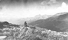
|
View from the summit of Berthoud Pass | |
| Elevation | 11,307 ft (3,446 m) |
| Traversed by |
|
| Location | Clear Creek / Grand counties, Colorado, United States |
| Range | Rocky Mountains |
| Coordinates | 39°47′52″N 105°46′37″W / 39.79778°N 105.77694°W |
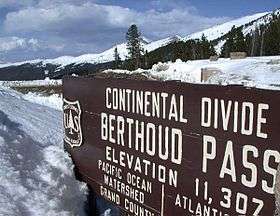
Berthoud Pass (/ˈbɜːrθəd/ BURTH-əd; el. 11,307 ft./3446 m.) is a high mountain pass in the Rocky Mountains of central Colorado in the United States.
The pass is located west of Denver, and provides a high route between upper Clear Creek Canyon to the upper valley of the Fraser River in Middle Park to the north. The pass traverses the continental divide at the Front Range, on the border between Clear Creek County and Grand County.
The pass is named for Edward L. Berthoud, the chief surveyor of the Colorado Central Railroad during the 1870s. Accompanied by Jim Bridger, Berthoud discovered the pass in July 1861 while surveying a possible route for the railroad. Berthoud concluded that the pass was suitable as a wagon road, but not as a railroad, and was then hired by the Central Overland California and Pikes Peak Express Company to survey a route over the pass to Salt Lake.[1]
The pass is currently the route of U.S. Highway 40, north of its junction with Interstate 70 in Clear Creek Canyon. It provides the fastest road access to Winter Park and a secondary route to Steamboat Springs from Denver and the Colorado Front Range. However, the pass is one of the most notoriously difficult passes in Colorado for motorists, based on its height as well as the steep grades on both sides (6.3%) and the large number of switchbacks on the southern side of the pass. At least 55 avalanche paths have been mapped on Berthoud Pass; with some of them intersecting U.S. Highway 40, and a smaller subset of paths intersecting the roadway at multiple points on the pass.[2] In 2015, CDOT installed an automated propane-fueled avalanche mitigation system consisting of five units that create concussive blasts to mitigate snow slab buildup on avalanche path #5, Stanley.[3]
Berthoud Pass Ditch
In 1902, the 3.5 mile (5.6 km) Berthoud Pass Ditch began diverting water from the headwaters of the Fraser River over the continental divide into the basin of Clear Creek. Initially, this water was used for irrigation, but the cities of Northglenn and Golden purchased the ditch in the mid-1980s. The ditch has a capacity of 53.4 cubic feet per second (1.51m3/s), [4]
The ditch was blocked in 1999 by the collapse of the tunnel under the parking lot at the summit of the pass, but it was repaired the next year.[5] In the decade since the repairs, the ditch has typically diverted on the order of 500 acre-feet (600,000m3) per year.[6]
Berthoud Pass Ski Area

Once home to the now-defunct Berthoud Pass Ski Area, the pass is a destination for local backcountry skiers, snowboarders, and snowshoers due to its abundance of steep and challenging terrain and plentiful snow averaging 500 inches annually. The twisting road on both sides of the pass also makes "car shuttles" possible, eliminating the need for skiers and snowboarders to hike back to the top of the pass after each run.
The ski resort was closed in 2002 due to financial problems caused by lack of water and sewage at the top of the pass. In 2003 the lifts were taken down, while some people continued to ski using snowcats for lift transportation. In 2005 the Colorado DOT began using a fund to restore the area to its natural state. First on the list was the demolition of the historic lodge.

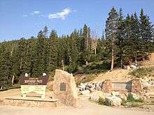
A new warming hut was opened at the top of the pass in May 2008, along with an expanded parking area, two scenic viewing areas and a new summit marker sign. The ski lodge and facilities had been in use since the early 1950s and the new warming hut includes modern features such as composting toilets, radiant floor heating and green construction.
Berthoud Ski resort is claimed by some to have been the first resort and lift in Colorado. Some say it was the first resort to openly welcome snowboarders.
The summit of Berthoud Pass is located at approximately 39°47′53.70″N 105°46′36.88″W / 39.7982500°N 105.7769111°W.[7]
Backpacking and recreation
Founded in 2003, Friends of Berthoud Pass is a grassroots collective of backcountry enthusiasts committed to preserving the legacy of public recreation at Berthoud Pass. They are a non-profit 501c(3) tax exempt organization managed by a volunteer executive board and supported by a diverse and active member base.
Berthoud Pass is a unique environment, where a major highway crosses the Continental Divide in a topographically and climatically ideal location that lends itself to a lengthy season of challenging deep powder skiing. This combination of elements at Berthoud Pass creates a unique set of circumstances for land managers, and FOBP has played a pivotal role in giving public voice to the policy process.
In its short history Friends of Berthoud Pass has endeavored to fashion a new paradigm in winter recreation on public land. They have successfully mobilized public involvement in lobbying the US Forest Service to incorporate the needs and wishes of winter backcountry users in redevelopment plans and positioned themselves as a key stakeholder in the public policy process.
The Friends of Berthoud Pass avalanche education curriculum has expanded from two classroom sessions in 2004 that reached 100 people, to a 2008 roster of eight classroom lectures educating more than 1,000 individuals in basic avalanche awareness and more than 150 participants in an on-snow practical course.
Climate
| Climate data for Berthoud Pass, Colorado (Elevation 11,313ft) | |||||||||||||
|---|---|---|---|---|---|---|---|---|---|---|---|---|---|
| Month | Jan | Feb | Mar | Apr | May | Jun | Jul | Aug | Sep | Oct | Nov | Dec | Year |
| Record high °F (°C) | 42 (6) |
47 (8) |
50 (10) |
57 (14) |
62 (17) |
70 (21) |
76 (24) |
75 (24) |
73 (23) |
63 (17) |
54 (12) |
47 (8) |
76 (24) |
| Average high °F (°C) | 21.2 (−6) |
24.2 (−4.3) |
28.7 (−1.8) |
36.2 (2.3) |
45.0 (7.2) |
54.2 (12.3) |
61.9 (16.6) |
59.9 (15.5) |
53.0 (11.7) |
42.4 (5.8) |
30.4 (−0.9) |
23.2 (−4.9) |
40.0 (4.4) |
| Average low °F (°C) | 1.4 (−17) |
2.0 (−16.7) |
6.2 (−14.3) |
13.6 (−10.2) |
23.1 (−4.9) |
32.0 (0) |
39.2 (4) |
38.0 (3.3) |
31.0 (−0.6) |
20.9 (−6.2) |
9.8 (−12.3) |
3.2 (−16) |
18.4 (−7.6) |
| Record low °F (°C) | −33 (−36) |
−34 (−37) |
−24 (−31) |
−12 (−24) |
−3 (−19) |
11 (−12) |
26 (−3) |
21 (−6) |
4 (−16) |
−5 (−21) |
−28 (−33) |
−30 (−34) |
−34 (−37) |
| Average precipitation inches (mm) | 3.49 (88.6) |
2.90 (73.7) |
4.11 (104.4) |
4.43 (112.5) |
3.85 (97.8) |
2.23 (56.6) |
2.45 (62.2) |
2.63 (66.8) |
2.05 (52.1) |
2.36 (59.9) |
3.36 (85.3) |
3.63 (92.2) |
37.48 (952) |
| Average snowfall inches (cm) | 49.8 (126.5) |
42.4 (107.7) |
57.9 (147.1) |
54.6 (138.7) |
37.2 (94.5) |
11.8 (30) |
0 (0) |
0.3 (0.8) |
8.7 (22.1) |
28.0 (71.1) |
49.1 (124.7) |
51.4 (130.6) |
391.2 (993.6) |
| Source: The Western Regional Climate Center[8] | |||||||||||||
References
- ↑ McGrath, Maria Davies (1934). The Real Pioneers of Colorado. The Denver Museum. p. 47. Retrieved November 14, 2013.
- ↑ http://avalanchemapping.org/IMAGES/Bpastopoweb.pdf
- ↑ http://www.denverpost.com/business/ci_28839606/high-mountain-passes-get-remote-controlled-avalanche-control
- ↑ John N. Winchester, A Historical View: Transmountain Development in Colorado, 2000; retrieved July, 2015.
- ↑ PAW, “The Ditch” on Berthoud Pass, Clear Creek County Document Center, 2012, retrieved Aug. 2015.
- ↑ Appendix IX. Transbasin Diversions, HB 1278 Final Report: The South Platte River Alluvial Aquifer, Colorado State University, Dec. 31, 2013; retrieved Aug. 2015.
- ↑ "US Gazetteer files: 2010, 2000, and 1990". United States Census Bureau. 2011-02-12. Retrieved 2011-04-23.
- ↑ "Seasonal Temperature and Precipitation Information". Western Regional Climate Center. Retrieved April 13, 2013.
9.Jack Kerouac; "On the road" When Dean and Carlo are talking to each other, Sal feels like "a man watching the mechanism of a watch that reached clear to the top of Berthoud Pass".
External links
- Berthoud Pass, Colorado
- USGS TopoZone listing
- Friends of Berthoud Pass
- Berthoud Pass Ski Area's History

Coordinates: 39°47′52″N 105°46′37″W / 39.79778°N 105.77694°W