Angoville, Calvados
| Angoville | |
|---|---|
 | |
 Angoville | |
|
Location within Normandy region  Angoville | |
| Coordinates: 48°56′45″N 0°22′39″W / 48.9458°N 0.3775°WCoordinates: 48°56′45″N 0°22′39″W / 48.9458°N 0.3775°W | |
| Country | France |
| Region | Normandy |
| Department | Calvados |
| Arrondissement | Caen |
| Canton | Thury-Harcourt |
| Intercommunality | Suisse Normande |
| Government | |
| • Mayor (2014–2020) | Éric Sohier |
| Area1 | 3.72 km2 (1.44 sq mi) |
| Population (2010)2 | 34 |
| • Density | 9.1/km2 (24/sq mi) |
| Time zone | CET (UTC+1) |
| • Summer (DST) | CEST (UTC+2) |
| INSEE/Postal code | 14013 / 14220 |
| Elevation |
173–248 m (568–814 ft) (avg. 220 m or 720 ft) |
|
1 French Land Register data, which excludes lakes, ponds, glaciers > 1 km² (0.386 sq mi or 247 acres) and river estuaries. 2 Population without double counting: residents of multiple communes (e.g., students and military personnel) only counted once. | |
Angoville is a French commune in the Calvados department in the Normandy region of north-western France.
The inhabitants of the commune are known as Angovillais or Angovillaises[1]
Geography
Angoville is located some 30 km south of Caen and 10 km east by south-east of Thury-Harcourt. The D6 road from Thury-Harcourt to Ussy forms the northern border of the commune. Access to the commune is by the D241 road from Tréprel in the south which passes through the length of the commune and the village and continues north to join the D6 on the border. The commune is mostly farmland with an area of forest in the south which is part of the large Bois de Saint-Claire.[2]
Neighbouring communes and villages[2]
 |
Meslay | Acqueville | Tournebu | |
| Donnay | |
Martainville | ||
| ||||
| | ||||
| Saint-Omer | Pierrefitte-en-Cinglais | Saint-Germain-Langot |
History
Toponymy
Angoville is composed of the old French "ville" (from the Latin "Villae") meaning a rural area or village and a Scandinavian name Asgaut (or Asgautr),[3] gallicized to Asgot, Ansgot, Angot, and Ango - originally the Norman surname Ango[4] and Angot[5] which are widespread in Seine-Maritime.
Administration
List of Successive Mayors of Angoville[6]
| From | To | Name | Party | Position |
|---|---|---|---|---|
| ? | ? | Louis-Aimable Auvray[7] | Farmer | |
| ? | ? | M. Pourdais (Father) | ||
| ? | 2001 | Guy Bourdais | ||
| 2001 | 2014 | Daniel Simon | SE | Farmer |
| 2014 | 2020 | Éric Sohier | SE | Editor |
(Not all data is known)
Demography
In 2010, the commune had 34 inhabitants. The evolution of the number of inhabitants is known through the population censuses conducted in the town since 1793. From the 21st century, a census of municipalities with fewer than 10,000 inhabitants is held every five years, unlike larger towns that have a sample survey every year.[Note 1]
| 1793 | 1800 | 1806 | 1821 | 1831 | 1836 | 1841 | 1846 | 1851 |
|---|---|---|---|---|---|---|---|---|
| 203 | 102 | 212 | 159 | 140 | 138 | 136 | 126 | 110 |
| 1856 | 1861 | 1866 | 1872 | 1876 | 1881 | 1886 | 1891 | 1896 |
|---|---|---|---|---|---|---|---|---|
| 110 | 104 | 98 | 97 | 100 | 97 | 86 | 87 | 80 |
| 1901 | 1906 | 1911 | 1921 | 1926 | 1931 | 1936 | 1946 | 1954 |
|---|---|---|---|---|---|---|---|---|
| 80 | 80 | 71 | 71 | 54 | 50 | 60 | 44 | 53 |
| 1962 | 1968 | 1975 | 1982 | 1990 | 1999 | 2006 | 2010 | - |
|---|---|---|---|---|---|---|---|---|
| 64 | 51 | 45 | 40 | 29 | 30 | 30 | 34 | - |
Sources : Ldh/EHESS/Cassini until 1962, INSEE database from 1968 (population without double counting and municipal population from 2006)

Economy
The main activities are dairy farming and cropping.
Culture and heritage
Civil heritage
The commune has a number of buildings and structures that are registered as historical monuments:
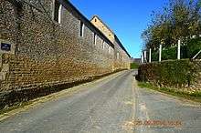
- Houses and Farms (18th-19th century)
 [8]
[8] - A Farmhouse (1786)[9]
- The Saint Anne Fountain (1848)[10]
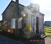
- The Town Hall (19th century)[11]
- The Motte de Rouvrou Fortified Site (11th century)[12]
Religious heritage

The commune has several religious buildings and structures that are registered as historical monuments:
- The Tomb of the Rabâche family (19th century)[13]
- The Tomb of Jean-François Rabâche (1816)[14]
- The Tomb of Priest François Bouquet (1813)[15]
- The Parish Church of Saint-Anne (12th century)[16]
See also
External links
- Angoville, Calvados on Lion1906
- Angoville on Google Maps
- Angoville on Géoportail, National Geographic Institute (IGN) website (French)
- Angoville on the 1750 Cassini Map
- Angoville on the INSEE website (French)
- INSEE (French)
Notes and references
Notes
- ↑ At the beginning of the 21st century, the methods of identification have been modified by law No. 2002-276 of 27 February 2002 , the so-called "law of local democracy" and in particular Title V "census operations" which allow, after a transitional period running from 2004 to 2008, the annual publication of the legal population of the different French administrative districts. For municipalities with a population greater than 10,000 inhabitants, a sample survey is conducted annually, the entire territory of these municipalities is taken into account at the end of the period of five years. The first "legal population" after 1999 under this new law came into force on 1 January 2009 and was based on the census of 2006.
References
- ↑ Inhabitants of Calvados (French)
- 1 2 Google Maps
- ↑ National Scientific Research Centre (France), Annals of Normandy, Volume 52, Nos. 1 to 5, Regional Ethnographic Laboratory, 2002 (French)
- ↑ Ango in Géopatronyme website (French)
- ↑ Angot in Géopatronyme website (French)
- ↑ List of Mayors of France (French)
- ↑ Annual of the department of la Manche, 12th edition, 1840, p 223
- ↑ Ministry of Culture, Mérimée IA00000570 Houses and Farms (French)
- ↑ Ministry of Culture, Mérimée IA00000569 Farmhouse (French)
- ↑ Ministry of Culture, Mérimée IA00000568 Saint Anne Fountain (French)
- ↑ Ministry of Culture, Mérimée IA00000564 Town Hall (French)
- ↑ Ministry of Culture, Mérimée IA00000568 Motte de Rouvrou Fortified Site (French)
- ↑ Ministry of Culture, Mérimée IA00000567 Tomb of the Rabâche family (French)
- ↑ Ministry of Culture, Mérimée IA00000566 Tomb of Jean-François Rabâche (French)
- ↑ Ministry of Culture, Mérimée IA00000565 Tomb of Priest François Bouquet (French)
- ↑ Ministry of Culture, Mérimée IA00000562 Parish Church of Saint-Anne (French)
| Wikimedia Commons has media related to Angoville. |