Brouay
| Brouay | |
|---|---|
 | |
 Brouay | |
|
Location within Normandy region  Brouay | |
| Coordinates: 49°12′47″N 0°33′47″W / 49.2131°N 0.5631°WCoordinates: 49°12′47″N 0°33′47″W / 49.2131°N 0.5631°W | |
| Country | France |
| Region | Normandy |
| Department | Calvados |
| Arrondissement | Caen |
| Canton | Tilly-sur-Seulles |
| Intercommunality | Thue et Mue |
| Government | |
| • Mayor (2008–2014) | Maurice Leredde |
| Area1 | 3.98 km2 (1.54 sq mi) |
| Population (2008)2 | 465 |
| • Density | 120/km2 (300/sq mi) |
| Time zone | CET (UTC+1) |
| • Summer (DST) | CEST (UTC+2) |
| INSEE/Postal code | 14109 / 14250 |
| Elevation |
50–84 m (164–276 ft) (avg. 60 m or 200 ft) |
|
1 French Land Register data, which excludes lakes, ponds, glaciers > 1 km² (0.386 sq mi or 247 acres) and river estuaries. 2 Population without double counting: residents of multiple communes (e.g., students and military personnel) only counted once. | |
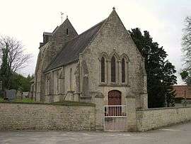
Brouay is a commune in the Calvados department in the Normandy region in northwestern France. There is a cemetery for war dead in the churchyard, with 377 graves of combatants killed during the Normandy campaigns - mostly from the United Kingdom.
Population
| Historical population | ||
|---|---|---|
| Year | Pop. | ±% |
| 1962 | 246 | — |
| 1968 | 277 | +12.6% |
| 1975 | 256 | −7.6% |
| 1982 | 238 | −7.0% |
| 1990 | 239 | +0.4% |
| 1999 | 320 | +33.9% |
| 2008 | 465 | +45.3% |
See also
References
| Wikimedia Commons has media related to Brouay. |
This article is issued from Wikipedia - version of the 3/16/2016. The text is available under the Creative Commons Attribution/Share Alike but additional terms may apply for the media files.