Amayé-sur-Seulles
| Amayé-sur-Seulles | ||
|---|---|---|
 | ||
| ||
 Amayé-sur-Seulles | ||
|
Location within Normandy region  Amayé-sur-Seulles | ||
| Coordinates: 49°04′51″N 0°42′47″W / 49.0808°N 0.7131°WCoordinates: 49°04′51″N 0°42′47″W / 49.0808°N 0.7131°W | ||
| Country | France | |
| Region | Normandy | |
| Department | Calvados | |
| Arrondissement | Caen | |
| Canton | Villers-Bocage | |
| Intercommunality | Villers-Bocage Intercom | |
| Government | ||
| • Mayor (2001–2020) | Pascal Cotard | |
| Area1 | 5.62 km2 (2.17 sq mi) | |
| Population (2010)2 | 200 | |
| • Density | 36/km2 (92/sq mi) | |
| Time zone | CET (UTC+1) | |
| • Summer (DST) | CEST (UTC+2) | |
| INSEE/Postal code | 14007 / 14310 | |
| Elevation |
91–194 m (299–636 ft) (avg. 160 m or 520 ft) | |
|
1 French Land Register data, which excludes lakes, ponds, glaciers > 1 km² (0.386 sq mi or 247 acres) and river estuaries. 2 Population without double counting: residents of multiple communes (e.g., students and military personnel) only counted once. | ||
Amayé-sur-Seulles is a French commune in the Calvados department in the Normandy region of northwestern France.
The inhabitants of the commune are known as Amayéens or Amayéennes[1]
Geography
Amayé-sur-Seulles is located four kilometres west of Villers-Bocage and 20 kilometres south of Bayeux in the Seulles valley. It can be accessed by road D71 coming west from Villers-Bocage through the heart of the commune and village and continuing west to Caumont-l'Evente. The road D193 running west from Cahagnes to Villers-Bocage forms the southern boundary of the commune. The road D215 also starts from the hamlet of Saint-German in the commune and runs south-west to Tracy-Bocage. There are also many small country roads in the commune. In addition to the village there are also the hamlets of Saint-German to the east and La Vallee to the north of the village. The commune consists entirely of farmland.[2]
La Seulles river passes through the northern part of the commune and Le Calichon which forms the northern boundary of the commune flows into it. Another stream which rises near the village flows north forming part of the eastern boundary of the commune and also joins La Seulles. In the south-east the Ruisseau du Caudray forms the south-eastern boundary of the commune and flows eastwards to join La Seulline river. The Ruisseau de Pont Chouquet flows into the Caudray and forms part of the eastern boundary of the commune.[2]
Neighbouring communes and villages[2]
 |
Livry | Anctoville | Saint-Louet-sur-Seulles | |
| Sept-Vents | |
Villers-Bocage | ||
| ||||
| | ||||
| Cahagnes | Coulvain | Tracy-Bocage |
Heraldry
_Calvados-France.svg.png) |
Blazon: Vert, 3 fesses wavy of argent between 3 cinquefoils of Or 2 and 1.. |
Administration
List of Successive Mayors of Amayé-sur-Seulles[3]
| From | To | Name | Party | Position |
|---|---|---|---|---|
| 1983 | 2001 | Charles Guilbert | SE | Farmer |
| 2001 | 2020 | Pascal Cotard | SE | Farmer |
(Not all data is known)
Demography
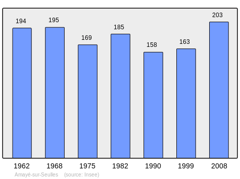
In 2010, the commune had 200 inhabitants. The evolution of the number of inhabitants is known through the population censuses conducted in the town since 1793. From the 21st century, a census of municipalities with fewer than 10,000 inhabitants is held every five years, unlike larger towns that have a sample survey every year.[Note 1]
| 1793 | 1800 | 1806 | 1821 | 1831 | 1836 | 1841 | 1846 | 1851 |
|---|---|---|---|---|---|---|---|---|
| 414 | 483 | 512 | 518 | 447 | 439 | 414 | 402 | 409 |
| 1856 | 1861 | 1866 | 1872 | 1876 | 1881 | 1886 | 1891 | 1896 |
|---|---|---|---|---|---|---|---|---|
| 385 | 366 | 379 | 356 | 340 | 335 | 290 | 289 | 283 |
| 1901 | 1906 | 1911 | 1921 | 1926 | 1931 | 1936 | 1946 | 1954 |
|---|---|---|---|---|---|---|---|---|
| 277 | 270 | 267 | 218 | 224 | 225 | 223 | 172 | 195 |
| 1962 | 1968 | 1975 | 1982 | 1990 | 1999 | 2006 | 2010 | - |
|---|---|---|---|---|---|---|---|---|
| 194 | 195 | 169 | 185 | 158 | 163 | 195 | 200 | - |
Sources : Ldh/EHESS/Cassini until 1962, INSEE database from 1968 (population without double counting and municipal population from 2006)
Sites and Monuments
- The Church of Saint-Vigor (15th century) belonged to the Abbey of Cerisy. It contains two items which are registered as historical objects:
- The Chateau of Bosq (18th century)
- The Clos d'Orval cider farm with an exhibition of old cider-making equipment.[6]
See also
External links
- Amayé-sur-Seulles on the old National Geographic Institute website (French)
- Amayé-sur-Seulles on Lion1906
- Amayé-sur-Seulles on Google Maps
- Amayé-sur-Seulles on Géoportail, National Geographic Institute (IGN) website (French)
- Amayé on the 1750 Cassini Map
- Amayé-sur-Seulles on the INSEE website (French)
- INSEE (French)
Notes and references
Notes
- ↑ At the beginning of the 21st century, the methods of identification have been modified by law No. 2002-276 of 27 February 2002 , the so-called "law of local democracy" and in particular Title V "census operations" which allow, after a transitional period running from 2004 to 2008, the annual publication of the legal population of the different French administrative districts. For municipalities with a population greater than 10,000 inhabitants, a sample survey is conducted annually, the entire territory of these municipalities is taken into account at the end of the period of five years. The first "legal population" after 1999 under this new law came into force on 1 January 2009 and was based on the census of 2006.
References
- ↑ Inhabitants of Calvados (French)
- 1 2 3 Google Maps
- ↑ List of Mayors of France (French)
- ↑ Ministry of Culture, Palissy PM14001050 Statue: Virgin and child (French)
- ↑ Ministry of Culture, Palissy PM14000003 Retable: Virgin and child
(French)

- ↑ Interprofession des appellations cidricoles website - the Clos d'Orval
| Wikimedia Commons has media related to Amayé-sur-Seulles. |