Asnières-en-Bessin
| Asnières-en-Bessin | |
|---|---|
|
The Church of Saint-Vigor | |
 Asnières-en-Bessin | |
|
Location within Normandy region  Asnières-en-Bessin | |
| Coordinates: 49°22′07″N 0°56′13″W / 49.3686°N 0.9369°WCoordinates: 49°22′07″N 0°56′13″W / 49.3686°N 0.9369°W | |
| Country | France |
| Region | Normandy |
| Department | Calvados |
| Arrondissement | Bayeux |
| Canton | Isigny-sur-Mer |
| Intercommunality | Trévières |
| Government | |
| • Mayor (2008–2020) | Patrick Deshayes |
| Area1 | 4.61 km2 (1.78 sq mi) |
| Population (2010)2 | 58 |
| • Density | 13/km2 (33/sq mi) |
| Time zone | CET (UTC+1) |
| • Summer (DST) | CEST (UTC+2) |
| INSEE/Postal code | 14023 / 14710 |
| Elevation |
12–49 m (39–161 ft) (avg. 50 m or 160 ft) |
|
1 French Land Register data, which excludes lakes, ponds, glaciers > 1 km² (0.386 sq mi or 247 acres) and river estuaries. 2 Population without double counting: residents of multiple communes (e.g., students and military personnel) only counted once. | |

Asnières-en-Bessin is a French commune in the Calvados department in the Normandy region of north-western France.
The inhabitants of the commune are known as Asnièrois or Asnièroises.[1]
Geography
Asnières-en-Bessin is located some 17 km west by north-west of Bayeux, 3 km west of Vierville-sur-Mer, and 4 km north by north-east of Longueville. Access to the commune is by the D194 road from Louvières in the east passing through the north of the commune and the village and continuing west to Cricqueville-en-Bessin. The D198 road goes south from the village through the length of the commune and continues to Aignerville. There is the hamlet of Le Temple just south of the village and Montigny in the south of the commune. The commune is entirely farmland.[2]
The Veret river flows through the centre of the commune from east to west and continues west then north-west to the sea at the Pont du Hable.[2]
Neighbouring communes and villages[2]
 |
Saint-Pierre-du-Mont | Vierville-sur-Mer | | |
| Cricqueville-en-Bessin | |
Louvières | ||
| ||||
| | ||||
| Deux-Jumeaux | Longueville | Formigny |
Administration
List of Successive Mayors[3]
| From | To | Name | Party | Position |
|---|---|---|---|---|
| 1983 | 2008 | Paulette Cuillandre | ||
| 2008 | 2020 | Patrick Deshayes | Farmer |
(Not all data is known)
Demography
In 2010 the commune had 58 inhabitants. The evolution of the number of inhabitants is known from the population censuses conducted in the commune since 1793. From the 21st century, a census of communes with fewer than 10,000 inhabitants is held every five years, unlike larger towns that have a sample survey every year.[Note 1]
| 1793 | 1800 | 1806 | 1821 | 1831 | 1836 | 1841 | 1846 | 1851 |
|---|---|---|---|---|---|---|---|---|
| 278 | 219 | 227 | 219 | 244 | 249 | 219 | 201 | 201 |
| 1856 | 1861 | 1866 | 1872 | 1876 | 1881 | 1886 | 1891 | 1896 |
|---|---|---|---|---|---|---|---|---|
| 185 | 191 | 186 | 166 | 147 | 141 | 165 | 141 | 148 |
| 1901 | 1906 | 1911 | 1921 | 1926 | 1931 | 1936 | 1946 | 1954 |
|---|---|---|---|---|---|---|---|---|
| 123 | 121 | 139 | 132 | 124 | 110 | 121 | 107 | 101 |
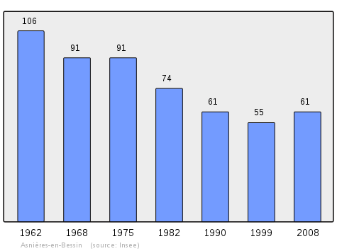
| 1962 | 1968 | 1975 | 1982 | 1990 | 1999 | 2006 | 2010 | - |
|---|---|---|---|---|---|---|---|---|
| 106 | 91 | 91 | 74 | 61 | 55 | 63 | 58 | - |
Sources : Ldh/EHESS/Cassini until 1962, INSEE database from 1968 (population without double counting and municipal population from 2006)

Sites and monuments
- Château of Asnières-en-Bessin, built in 1693, rebuilt in 1783.
 [4]
[4]
Notable people linked to the commune
- Arthur Le Duc (1848-1918), sculptor, was the Mayor of the commune from 1893 to his death in 1918.
- Albert Anne (1908-1944), a member of the resistance in the Alliance network,[5] (A resistance network in the interior of France during the Second World War) he was arrested by the Gestapo on 5 May 1944 at Asnières-en-Bessin, where he had used his skills as a forger,[5] and he was executed at Caen jail on 6 June 1944.
See also
External links
- Asnières-en-Bessin on Google Maps
- Asnières-en-Bessin on Géoportail, National Geographic Institute (IGN) website (French)
- Asnieres on the 1750 Cassini Map
- Asnières-en-Bessin on the INSEE website (French)
- INSEE (French)
Notes and references
Notes
- ↑ At the beginning of the 21st century, the methods of identification have been modified by Law No. 2002-276 of 27 February 2002, the so-called "law of local democracy" and in particular Title V "census operations" allows, after a transitional period running from 2004 to 2008, the annual publication of the legal population of the different French administrative districts. For communes with a population greater than 10,000 inhabitants, a sample survey is conducted annually, the entire territory of these communes is taken into account at the end of the period of five years. The first "legal population" after 1999 under this new law came into force on 1 January 2009 and was based on the census of 2006.
References
- ↑ Inhabitants of Calvados (French)
- 1 2 3 Google Maps
- ↑ List of Mayors of France (French)
- ↑ Ministry of Culture, Mérimée PA00111016 Château of Asnières-en-Bessin (French)
- 1 2 Omaha Beach Memories - the arrests of 1944, consulted on 30 April 2013 (French)
| Wikimedia Commons has media related to Asnières-en-Bessin. |