Almatti Dam
| Almatti dam ಆಲಮಟ್ಟಿ ಅಣೆಕಟ್ಟು | |
|---|---|
 Almatti Dam with its right bank power house | |
| Official name | Upper Krishna-I (Almatti) |
| Location | Vijaypur district, Karnataka - Basavana Bagewadi Taluk, North Karnataka |
| Coordinates | 16°19′52″N 75°53′17″E / 16.331°N 75.888°ECoordinates: 16°19′52″N 75°53′17″E / 16.331°N 75.888°E |
| Opening date | July 2005 |
| Construction cost | Rs. 5.20 billion |
| Operator(s) | Karnataka Power Corporation Limited |
| Dam and spillways | |
| Impounds | Krishna River |
| Height | 52.25 m |
| Length | 1565.15 m |
| Reservoir | |
| Total capacity | 123.08 Tmcft at 519 m MSL |
| Catchment area | 33,375 sq. km |
| Surface area | 24,230 hectares |
| Minimum Draw Down Level : 504.75 m MSL | |
The Almatti Dam (Kannada:ಆಲಮಟ್ಟಿ ಅಣೆಕಟ್ಟು) is a hydroelectric project on the Krishna River[1] in North Karnataka, India which was completed in July 2005. The target annual electric output of the dam is 560 MU (or GWh).[2]
The Almatti Dam is the main reservoir of the Upper Krishna Irrigation Project; the 290 MW power station is located on the right side of the Almatti Dam. The facility uses vertical kaplan turbines: five 55MW generators and one 15MW generator. Water is released in to the Narayanpur reservoir after using for power generation to serve the downstream irrigation needs.
During the initial stages of the project, estimated costs were projected as Rs.14.70 billion, but following the transfer of project's management to the Karnataka Power Corporation Limited (KPCL), the estimated cost was reduced by over fifty percent to Rs. 6.74 billion. The KPCL eventually completed the project at an even lower cost of Rs. 5.20 billion. The entire dam was finished in less than forty months, with construction ending in July 2005. The dam is located on the edge of Bijapur and Bagalkot districts. Geographically, it is located in the Bijapur district,[3] but large areas of Bagalkot district have also been submerged due to filling of the reservoir. The dam holds a gross water storage capacity of 123.08 TMC at 519 meters MSL.[3][4]
Height
The full reservoir level of Almatti dam was originally restricted to 519 meters MSL by the supreme court of India.The Krishna River conflict between Andhra Pradesh, Karnataka, and Maharashtra was resolved by the Brijesh Kumar Tribunal and the dam was authorised to be raised to the height of 524 meters MSL with nearly 200 TMC gross storage capacity.
Picnic spot
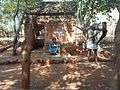
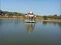
Seven terrace gardens have been developed as a picnic spot in the dam area.[5] Boating, musical fountains, and stagnant fountains have been set up in the area. On one side of the dam, a garden named "Rock hill" has an artificial forest with ceramic wild animals and birds and many idols representing village life in India.
How to reach
Almatti is about 66 km away from Vijayapur and takes about 1 hr, 10 mins by train.[6]
Photos of Rock hill garden at Almatti


See also
- Upper Krishna Project
- Krishna Water Disputes Tribunal
- List of dams and reservoirs in India
- Kudalasangama
- Aihole
- Pattadakal
- Mahakuta
- Badami
- Banashankari
- North Karnataka
- Bijapur
- Tourism in North Karnataka
References
| Wikimedia Commons has media related to Almatti Dam. |
- ↑ "Map of Krishna River basin"
- ↑ CEA Monthly Generation Report
- 1 2 Upper Krishna project at Karnataka water resources website
- ↑ Oasis (4 August 2011). "How to Reach any City in India". howtoreach.info. Blogger. Retrieved 25 March 2012.
- ↑ "Mughal garden to open on Republic Day". The Times of India. 23 August 2010. Retrieved 6 February 2012.
- ↑ "Alamatti Almatti Dam Hotels Accommodation Resorts Karnataka". Travel Karnataka. Retrieved 6 February 2012.
External links
- Almatti Dam Power House at Karnataka Power Corp
- Alamatti Dam
| Rivers | 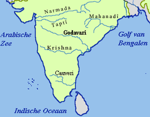 | ||||||||||||||
|---|---|---|---|---|---|---|---|---|---|---|---|---|---|---|---|
| Dams and barrages | |||||||||||||||
| Hydro power stations | |||||||||||||||
| Geographical features/regions | |||||||||||||||
| Riparian districts |
| ||||||||||||||
| Cities | |||||||||||||||
| Ores and minerals | |||||||||||||||
| Oil/gas fields | |||||||||||||||
| Industries |
| ||||||||||||||
| Transport | |||||||||||||||
| Related topics | |||||||||||||||
| Other river basins | |||||||||||||||
Dams on the Krishna River | |
|---|---|