Bijapur
| Vijayapura ವಿಜಾಪುರ, ವಿಜಯಪುರ Bijapur, Bijjanahalli, Vijayapura विजयपुर | |
|---|---|
| Corporation City | |
 | |
 Vijayapura  Vijayapura | |
| Coordinates: 16°50′N 75°43′E / 16.83°N 75.71°ECoordinates: 16°50′N 75°43′E / 16.83°N 75.71°E | |
| Country |
|
| State |
|
| District | Bijapur District |
| Area | |
| • Total | 10.541 km2 (4.070 sq mi) |
| Elevation | 770 m (2,530 ft) |
| Population (2011) | |
| • Total | 327,427 |
| • Density | 265/km2 (690/sq mi) |
| Languages | |
| • Official | Kannada |
| Time zone | IST (UTC+5:30) |
| PIN | 586101-586105 |
| Telephone code | 08352 |
| Vehicle registration | KA-28 |
| Website |
bijapur |
Bijapur officially known as Vijayapura,[1] is the district headquarters of Bijapur District of Karnataka state. It is also the headquarters for Bijapur Taluka. Bijapur city is well known for its historical monuments of architectural importance built during the rule of the Adil Shahi dynasty. Bijapur is located 530 km northwest of Bangalore and about 550 km from Mumbai, and 384 km west of the city of Hyderabad.
Bijapur urban population as per 2011 census is 326,000, perhaps the 9th biggest city in Karnataka. Vijayapura Mahanagara Palike(VMP) is the newest Municipal Corporation formed under the KMC act along with Shivamogga and Tumakuru Municipal Corporations. The other existing city corporations in Karnataka state in descending order of population are Bengaluru, Hubballi-Dharawada, Mysuru, Kalaburgi, Belagavi, Mangaluru, Davangere and Ballari. Administratively, Bijapur district comes under Belgaum division along with Bagalkote, Belgaum, Dharwad, Gadag, Haveri and Uttara Kannada (Karwar) districts.
Bijapur, the land of five rivers and the domain of different cultures, is an ancient city. The city established in the 10th and 11th centuries by the Chalukyas of Kalyani was known as Vijayapura (City of victory). Bijapur was the biggest district place of the state with 11 taluks, but after forming Bagalokote new district in 1997 Now it consists of five taluks viz. Basavan Bagevadi, Bijapur, Indi, Muddebihal and Sindagi.
The city was established in the 10th-11th centuries by the Kalyani Chalukyas and was known as Vijayapura (City of victory). The city was passed to Yadavas after Chalukya's demise. The city came under the influence of the Khilji Sultanate in Delhi by the late 13th century. In 1347, the area was conquered by the Bahmani Sultanate of Gulbarga. By this time, the city was being referred as Bijapur.
History
In 1518, the Bahmani Sultanate split into five splinter states known as the Deccan sultanates, one of which was Bijapur, ruled by the kings of the Adil Shahi dynasty (1490–1686). The city of Vijayapura owes much of its greatness to Yusuf Adil Shah, the founder of the independent state of Bijapur. The rule of this dynasty ended in 1686, when Bijapur was conquered during the reign of Mughal emperor Aurangzeb. In 1724 the Nizam of Hyderabad established his independence in the Deccan, and included Bijapur within his dominions. In 1760, the Nizam suffered a defeat by the Marathas, and ceded the region of Bijapur to the Maratha Peshwa. After the 1818 defeat of the Peshwa by the British in the Third Anglo-Maratha War, Bijapur passed into the hands of the British East India Company, and was assigned to the princely state Satara.
Bijapur district is historically, traditionally and legendarily, one of the richest districts in the state. The evidence found here reveals that it was an inhabited place since the Stone Age. Many places of this district have legendary history. The history of this district is divided into four periods, from the Chalukya acquisition of Badami till the Muslim invasion.
- Early Western Chalukya period lasting from about A.D. 535 to about A.D.757.
- Rastrakuta period from A.D. 757 to A.D.973
- Kalachuri and Hoysala period from A.D. 973 to about A.D.1200
- Devagiri Yadava period from A.D.1185 to the Muslim conquest of Devagiri in A.D. 1312.
Bijapur came under Muslim influence, first under Allaudin Khilji, the Sultan of Delhi, towards the end of the 13th century, and then under the Bahamani kings of Bidar in 1347. In 1347, when the Bahamani dynasty was established, it included southern and eastern parts of Bijapur district. The supremacy of the Bahaman's may be said to have ceased by 1489. At that time five Shahi Dynasties were born and one of them was "Bijapur‟. The Mughal emperor Aurangajeb conquered Bijapur in 1686 and it was under Mughal rule up to 1723. In 1724 the Nizam of Hyderabad established his independence in the Deccan and included Bijapur within his dominions. However, his acquisition on this portion was of brief duration, in 1760 it went into the hands of Marathas. In 1817, war broke out between the British and the Marathas. By 1818, the whole of Bijapur was occupied by the British and was included in the territory assigned to the Raja of Satara. In 1848 the territory of Satara was obtained through the failure of heir and the British rule started. Till 1884, the Bijapur district had headquarters at Kaladagi. Bijapur was made headquarters in 1885.
After Independence, the movement for re-organisation of States gained further momentum and on 1 November 1956 a separate "Mysore State‟ was formed. By the wish of the people it was renamed as "Karnataka‟. Thus, the district Bijapur along with other Kannada speaking areas became a part of "Karnataka State‟ on 1 November 1956.
Central government had approved the request to rename the city in October 2014 from Bijapur to "Vijayapura" on November 1, 2014.[2]
Description
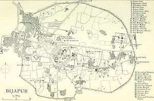
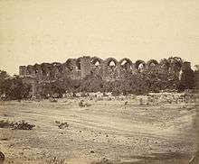
The city consists of three distinct portions: the citadel, the fort and the remains of the city. The citadel, built by the Adilshahi Sultans, a mile in circuit, is of great strength, well built of the most massive materials, and encompassed by a ditch 100 yards (91 m) wide, formerly supplied with water.The fort, which was completed by the Adilshahi Sultans in 1566, is surrounded by a wall 6 m. in circumference. This wall is from 30 to 50 ft (15 m) high, and is strengthened with ninety-six massive bastions of various designs. In addition there are ten others at the various gateways. The width is about 25 ft (7.6 m); from bastion to bastion runs a battlement curtained wall about 10 ft (3.0 m) high. The whole is surrounded by a deep moat 30 to 40 ft (12 m) broad. Inside these walls the Bijapur kings bade defiance to all comers. Outside the walls are the remains of a vast city, now for the most part in ruins, but the innumerable tombs, mosques, which have resisted the havoc of time, afford abundant evidence of the ancient splendor of the place. Badami, Aihole, and Pattadakal, near Bijapur, are noted for their historical temples in the Chalukya architectural style.
Bijapur is nearly 530 km from the state capital Bangalore. It lies between North latitude 15.20 and 17.28 and East longitude 74.59 and 76.28. It is situated well in the interior of the Deccan Peninsula and is about 130 miles away from the West Coast.
The district is bounded by Solapur district on the North and Sangali on the North-West, Belgaum district on the West, Bagalkot on the South, Gulbarga on the East and by Raichur on the South-East.
Attractions and Tourism

In an introduction to an album of Bijapur published in 1866, Philip Meadows Taylor wrote: “Palaces, arches, tombs, cisterns, gateways, minarets, ...all carved from the rich basalt rock of the locality, garlanded by creepers, broken and disjointed by peepul trees, each in its turn is a gem of art and the whole a treasury.”[3]

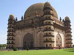
Gol Gumbaz
This is the most famous monument in Bijapur. It is the tomb of Mohammed Adil Shah (ruled 1627-1657).[4] It is the largest dome ever built in India, next in size only to St Peter's Basilica in Rome. A particular attraction in this monument is the central chamber, where every sound is echoed seven times. Another attraction at the Gol Gumbaz is the Whispering Gallery, where even minute sounds can be heard clearly 37 metres away. Gol Gumbaz complex includes a mosque, a Naqqar Khana (a hall for the trumpeters) (Now it is used as museum) and the ruins of guest houses.
The Archaeological Museum
It has several curious objects like inscriptions, sculptures, paintings, manuscripts, and weapons etc., displayed. It is near Gol Gumbaz and is run by the Archaeological Survey.
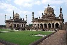
Ibrahim Rauza
This is the tomb of Ibrahim Adil Shah II (ruled 1580-1627), the fifth king of the dynasty and, like the Mughal emperor Akbar, known for religious tolerance. Built on a single rock bed, it is noted for the symmetry of its features. It is said that the design for the Ibrahim Rauza served as an inspiration for that of the famous Taj Mahal.
It is situated on the western outskirts of the city. Ibrahim Rauza comprises two buildings, a magnificent tomb and a remarkable mosque enveloped by a garden. Facing each other, these twin buildings have a fountain in between them. A Persian inscription here records the construction of this Rauza in 1626. These buildings stand on a raised terrace supported by arches in a large rectangular enclosure with a high entrance tower in the centre of the north side, adorned with four graceful minarets. This is the most ornate building in Bijapur. Both the buildings have square plans with four minarets at the corners and a bulbous dome at the centre, which emerges from lotus petals. Cousins called the building as “The Taj Mahal of the Deccan”.
King Edward VII Memorial
In British India, a tower with a marble structure with a bust of King Edward VII and a park around the tower were established in memory of King Edward VII, Emperor of India. The memorial is situated in the heart of the city, and the foundation stone for the memorial was laid on 2 November 1913 by Lord Hardinge, Viceroy of British India. Built in the Indo-Islamic architecture, the memorial served as an attraction for children. The memorial once had beautiful fountains and taps providing drinking water. It was the equivalent of Bangalore's Cubbon Park or Lalbagh for the residents of Bijapur. However, mismanagement by government in the 1970s resulted in the destruction of the park. There was a proposal to demolish the memorial, and establish a deer park, and then a Ranga Mandira. All these projects were not successful, and only resulted in destruction of the park. On the site of park, a godown, Kandagal Hanamantharaya Ranga Mandira, district Lokayukta office and Information Department buildings have been constructed, and the memorial has been reduced to only a few feet. Today, there is no sign of the beautiful park, which once stood, and the neglected statue of King Edward VII stands testimony to the neglected heritage.[5]
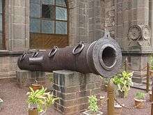
Malik-e-Maidan (The Monarch of the Plains)
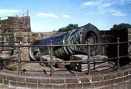
The largest medieval cannon in the world. Being 4 m long, 1,5 m in diameter and weighing 55 tons, this gun was brought back from Ahmadnagar in the 17th century as a trophy of war by 400 oxen, 10 elephants and tens of men.it was given by a Turkish Officer in the service of Burhan Nizamshah and this information is engraved on it. It was placed on the Sherza Burj (Lion Gate) on a platform especially built for it. The cannon's nozzle is fashioned into the shape of a lion's head with open jaws & between the carved fangs is depicted an elephant being crushed to death. It is said that after igniting the cannon, the gunner would remain underwater in a tank of water on the platform to avoid the deafening explosion. The cannon remains cool even in strong sunlight and if tapped, tinkles like a bell. In 1854 the cannon was auctioned for Rs. 150 but the sale was cancelled in the end.it is placed to the north of Phatka gate in a tower. ,
Upli Buruj
Built around 1584 by Hyder Khan, is an 80 ft (24 m) high tower standing to the north of Dakhani Idgah in Bijapur. This is a spherical structure with stone steps winding round the outside. Top of the tower offers a commanding view of the city. This is also known as Hyder Burj, Upli Burj. On top of Upli Burj there are two guns of huge size. The parafeet this tower which was used for monitoring purposes has been fenced now. One needs to climb the circular stairs to reach the top. However except for this tower there is very little evidence of the citadel wall in this area due to rampant construction.
Chand Bawdi
Ali Adil Shah (1557–1580) built this tank near eastern boundary of Bijapur. When there was large influx of people into Bijapur after the fall of the Vijayanagar empire, and new settlements came up within the walled city raising the need for better infrastructure and providing water supply. This has a storage capacity of 20 million litres. Later it became a model for many other tanks constructed in the city. A grandeur complex came up around it, which was mainly used to house the maintenance staff though members of the royal family occasionally used it for recreation. He named this after his wife "Chand Bibi".
Asar Mahal
The Asar Mahal was built by Mohammed Adil Shah in about 1646, which was used to serve as a Hall of Justice. The building was also used to house hairs from the Prophet's beard. The rooms on the upper storey are decorated with frescoes and the front is graced with a square tank. Here women are not allowed inside. Every year there is urs (festival) held at this place. In front of the hall, one can see three tanks the bigger tank, which is at the centre is about 15 feet (4.6 m) deep however the other two are comparatively smaller in size as well as depth. Behind Asar Mahal one can still see the remain of the citadel. Just a kilometer away behind Asar Mahal, one can still find the old mosque which is on top of the citadel wall. There is a big entrance with arc below this mosque. Many stones have inscriptions. The site is under maintenance of Archaeological Survey of India.
Gagan Mahal
Which means Sky Palace, is built with a 21- meter façade and four wooden massive pillars, has a majestic central arch. Sikandar Adil Shah, in silver chains, surrendered to Aurangzeb in 1681 here.
Barakaman (Ali Roza-II)
A mausoleum of Ali Roza built in 1672. It was previously named as Ali Roza, but Shah Nawab Khan changed its name to Bara Kaman as this was the 12th monument during his reign. It has now seven arches and the tomb containing the graves of Ali, his queens and eleven other ladies possibly belonging to the Zenana of the queens.
Saat Kabar
Meaning sixty graves, is a site which can aptly be called as the 'dark tourist spot'. Saat Kabar may not have any intricate or wonderful architectural characteristics like the Gol Gumbaz or Ibrahim Roza to offer to its visitors, but the heart-rending story it narrates makes it a spot worth visiting. This heritage site tells the story of a passionate army chief who killed his 63 wives fearing they would remarry after his death. Afzal Khan, the army chief of Ali Adil Shah II of the Adil Shahi Dynasty that ruled Bijapur for four centuries, cold bloodedly murdered all his wives, one by one, before setting out on a battle with Shivaji, the great Maratha warrior, at Pratapgad in Maharashtra in 1659. Sick of continuous attacks by Aurangzeb on one side and Shivaji on the other side, Ali Adil Shahi-II ordered Afzal Khan to contain these two enemies to protect the empire. Although known for his bravery, Khan was a firm believer in astrology. He always consulted soothsayers before setting out on a war. When an astrologer predicted about his defeat and sure death in the battle against Shivaji, he decided to kill all his wives so that they would not remarry after his death. Hence he led all his wives to a huge well in a lonely place on the outskirts of the city and pushed them into it one after another. Later, he buried their bodies near the well. Seeing this horrifying act, two of his wives tried to escape, but in vain. They were chased and killed by soldiers, reveal historical records.
Malik-Karim-ud-dins
Mosque is standing at the east of the Chini Mahal. The mosque appears to be a Hindu temple originally. An inscription inside the pillar in old Kannada characters dated 1320 A.D. says the name of the builder of the upper part as Ravayya of Salotgi. It is a rectangular enclosure with a fine vestibule in front, the portico of which spreading into wings fills the forepart of the mosque. According to another version, earlier it was a Hindu college, converted into a mosque.
Jami Masjid
It is the largest and oldest mosque in the Deccan. It is at 1200 yards to the east of the citadel. Ali Adil Shah I, after his triumphant victory over Vijayanagara built this mosque. It is a mosque, rectangle in shape, about 400 feet (120 m) from east to west and 280 feet (85 m) from north to south. The main entrance is from the east side and there is a pavilion ascribed to Aurangzeb at the entrance. Including the entire big open court spread between two wings, the mosque occupies an area of 116,300 square feet (10,800 m2) and unmatched by any building in Bijapur. The columns in the main building divide the floor into 45 equal squares. The most beautiful feature is the dome of this building which is highly proportionate. The mihrab here is gorgeously painted.
Jod Gumbaz
It is behind the Government High School. A pair of tombs is housed in this. The floors of both the tombs are at a very considerable elevation, as the graves have been built at floor level. Both the buildings have galleries within the domes. Afzal khan’s cenotaph is at a distance of about four km from the gate way of Shahapur. There is a mosque too. Afzal khan commenced the construction of his own splendid tomb in his lifetime. But he was not buried in the tomb. About one km towards south of Afzal khan’s tomb are his wives’ tombs on a masonry platform consisting of 11 rows of graves. There are 63 graves and one is empty. It is said that Afzal Khan believed in one astrologer’s prediction that he would never return to Bijapur when he went to meet Shivaji, and had all his 64 wives drowned before his journey, except one who escaped. That is how one grave is empty.
Green Stone Sarchophagus
It is a tomb at a little distance to the south of Ali I’s tomb. It is finely cut and molded in a dark greenish black-basalt, standing on a raised large platform. The name of the buried person is not known.
Jala Manzil
It is a small tidy square structure, to the north of the Sat-Manzil standing in the middle of a dry reservoir, which was exclusively meant as a pleasure spot for the royal family.
Landa Kasab Gun
Lies in the middle of the southern fort of the City. It weighs about 46.5 tons, and there is another small gun on the same bastion. Though unprotected for 300 years from the rig ours of climate, these guns show no signs of decay.
Sat-Manzil
It is part of the mansion that now remains to the west of the citadel. In this dilapidated five-storeyed building are traces of painting, and stucco work has been executed on the ceiling of the different floors.
Taj Bavadi
To the west of the Mecca gateway, about 100 yards away is Taj Bavadi. The well is 223 feet (68 m) in square and 52 feet (16 m) deep.
Mehatar Mahal
It is about 260 yards to the south of the Jumma Masjid-Ark-killa road. Actually it is not a palace but an ornamental gateway which leads to a mosque and garden. Its flat stone roof has been a puzzle to engineers, which is supported by delicately carved stone brackets of birds.
Malika Jahan Begam’s Mosque
It is stands about 100 yards west of the citadel, built by Ibrahim Adil Sha II in honour of his wife Mallika Jahan Begam. The columns of the arches are very fine and the stucco work is very good.
Malik Sandals Mosque
It stands about 75 yards north of Bukhara Mosque. It is a peculiar combination of Hindu-Muslim architecture. The roof is borne not on arches but on eight-sided columns with Hindu pedestals and capitals. The construction is in Hindu style except the central dome and the western mihrab.
Mecca mosque
It is situated near the middle of the citadel. It is one of the finest and smallest mosques here. It appears to belong to the period of Ibrahim II.
Shanmukhaswami Mutt
It is located near the great Gol Gumbaz. It was founded by Saint Shanmukhaswami. A big front hall surrounded by an open yard has a cellar containing the Samadhi of Shanmukhaswami.
Narasimha temple
It is a highly revered temple situated on the west centre of the citadel on the inner most under a papal tree. It is being popularly called as Narasoba or Narasimha temple. The chief object of worship is a shapeless black stone in the form of Dattareya. A pair of sandals or padukas said to belong to Saint Narasimha Saraswathi are worshipped there. It is said to be frequented by Ibrahim Adil Shah II.
Parshwanath Basadi
About 3 km from the city near the dargah is a basadi of Parshwanath. The black stone idol is about 3 feet (0.91 m) high and of beautiful workmanship. A serpent with 1008 small hoods spread over the deity as umbrella is delicately carved. Some years back while digging a mound, the figure is stated to have been unearthed.
Torvi Narasimha Temple
Torvi is located merely 5 km from Bijapur.The Narasimha temple, which is built underground is very close to Adil Shahi's Sangeeth mahal. Nearby this temple, another Hindu temple of Devi Lakshmi is located.The people of Bijapur have a trend to visit these temples every Saturday.
Shree Siddeshwar Temple
Shree Siddeshwar Temple is located in heart of the city. It is on behalf of Solapur Shree Siddarameshwar of Basav's Saints (Sharanas).
Basavan Bagewadi
Basavan Bagewadi is birthplace of Lord Basavanna.Here beautiful Nandi Temple had constructed in 11th century. It is under management of Kudal Sangam Development Authority.
Alamatti Dam (Lal Bahaddur Shastri Sagar)
Alamatti Dam is situated in NH -13 border of Bijapur-Bagalkot twin Districts of Karnatak State. It is a best tourist place in Bijapur District.
About the city
- The place is an important tourist place in the country, the former capital of the Adilshahi dynasty, situated about 579 km to the north-west of Bangalore. The Hubli-Sholapur railway line traverses via this place. The Kalyana Chalukya kings made it a sub-capital according to an inscription of 1073. It is believed that Jaina Poet Nagachandra, 12th century, had his residence here. The place had old names like Vijayapura, Vidyapura and Mohamudpura. For nearly 200 years from 1489 to 1686, this was the seat of the Adilshahi Dynasty.
- Among the other historical attractions at Bijapur, some notable ones are the Anand Mahal, Jod Gumbaz, Jumma Mosque, Sat Manzil, and Jal Manzil. Also among old houses at Bijapur, the most famous is Elavia House ( Nauzer Elavia) which is more than 100 years old.
- Bijapur City was also held by Aurangzeb, the Nizam, Savanur Nawab, Satara Chatrapati and finally the British. Foreign travelers like Duarte Barbosa, Varthema, Poser, Mandeslo and Travernier visited this place.
- The Ibrahim Rauza and the Gol Gumbaz are the most impressive monuments at Bijapur. A brief survey of spots of note in the city is given below.
- Ain-ul-mulk’s tomb and mosque Lies on the eastern outskirts of the city and is the solid structure in square, surrounded by a fair proportioned dome. The tomb belongs to Ain-ul-mulk. Close by is the much adorned mosque and the building is plastered.
- Ali Adilshah I’s tomb lies in the south-west part of the City. Ali Adilshah’s Tomb is a simple modest building containing an outer row of five arches surrounding a central chamber and is the earliest royal mausoleum in Bijapur.
- Ali Adil Sha II’s tomb is located to the north-west of the citadel, and is housed in a big square roofless structure consisting of incomplete arches in dark basalt. This incomplete structure is 215 feet (66 m) square and on the raised platform stand the incomplete arches. In the centre on the elevated platform are the tombs.
- Ali Shahi Pir’s mosque and tomb is a square massive structure, its mihrab is remarkable in some ways. The tomb of the saint is outside the north-east gate of the mosque.
- Amin Dargah Is considered as the most sacred in the city and is situated about 1.5 km to the west of Bijapur. The tomb of Amin-ud-din is on the high ground and conspicuous landmark for considerable distance round about.
- Anand Mahal Is to the west of Gagana Mahal and in the premises of the citadel stands this two-storeyed mansion. This was constructed by Ibrahim Adil Sha II in 1589, exclusively for music and dance. The roof was ornamented with stucco work. The Ananda Mahal presently is being used by the State for Government offices.
- Andu Masjid stands a little away from the citadel to the west of the Jumnal road. It is a two-storeyed structure, upper floor being a prayer chamber while the ground is a hall. There is no pulpit in the mosque and probably it was restricted to the prayer of women. A Persian inscription here quotes that the mosque was constructed in 1608 by Itbar Khan, one of the nobles in the Court of Adil Shai II.
- Aras Mahal Is to the south-east of Adalat Mahal and was once a joy resort of Ali II. It is now the residence of the District Surgeon.
- Ark-Killa the citadel is at the centre of the city. It is also most important part of Bijapur. Yusuf Adilshah chose it as the site for his fort. The present citadel is nearly circular. Its defenses are a strong wall with several bastions of considerable strength on the south and east.
- Asar Mahal on the crest of the eastern glacis of the citadel is the Asar Mahal. In about 1646 it was constructed by Muhammad Shah and was earlier called as Adalat Mahal. The walls and ceilings of the rooms bear paintings of landscapes and various designs. The room of the south side of the gilded hall is a gorgeously painted apartment. These paintings had been whitewashed by the orders of Aurangzeb and later restored. There is a big square tank outside in front of the building.
- Aurangzeb Idgah Is a large square enclosure built by Aurangzeb in 1682 after the occupation of the city as a gathering place for Muslims on important days.
- Bukhati Masjid is believed to have been constructed by Chandbibi for a moulvi of the Bukhari family. On a door is a Persian Inscription.
- Chand Bavadi is a well constructed by Ali Adil Shah I in honor of his wife Chand Bibi in the year 1579. It is at the west corner of the town. The entrance is spanned by a single arch, approached by a descending flight of steps.
- Chota Asar is a small building, remarkable for the amount of rich ornamentation in stucco which covers the wall, ceiling and a portion of the façade.
- Chini Mahal or Faroukh Mahal is an edifice that consists of a big lofty durbar hall in the centre and series of rooms in the wings. Yusuf Adil Shsh constructed it. For its sheer size and loftiness none of the hall in any other palace of Bijapur can be compared with it.
Visit
Air – The nearest airport is at Belgaum (205 km). Indian and Jet airways flight operators connect Bijapur to the rest of India. A new airport which can accommodate ATR's & Airbus 320 (expansion afterwords) is currently being built by Karnataka government through PPP mode. Land has already been acquired & construction has already started.
Rail – Bijapur is well connected by rail with Bangalore and other major cities of India (Bombay, Hyderabad, Hubli and Solapur). It has its own railhead that is located just 2 km from the main town.
Road – The main stand in Bijapur is near the southwestern side of the citadel, near the city center. Bus services to Badami, Belgaum, Almatti, Gulbarga, Bidar, Hubli, and Solapur are frequent.
Sufis of Bijapur

Arrival of Sufis in Bijapur region was started during the reign of Qutbuddin Aibak. During this period Deccan was under the control of native Hindu rulers and Palegars. Shaikh Haji Roomi was the first to arrive in Bijapur with his companions. Although his other comrades like Shaikh Salahuddin, Shaikh Saiful Mulk and Syed Haji Makki were settled in Pune, Haidra and Tikota respectively.
According to Tazkiraye Auliyae Dakkan i.e., Biographies of the saints of the Deccan, compiled by Abdul Jabbar Mulkapuri in 1912–1913,
| “ | Sufi Sarmast was one of the earliest sufi of this region. He came to the Deccan from Arabia in the 13th Century at a time when the Deccan was a land of unbelievers with no sign of Islam or correct faith anywhere. His companions, pupils (fakir), disciples (murid), and soldiers (ghazi), numbered over seven hundred. He settled in Sagar in Sholapur district. There, a zealous and anti-Muslim raja named Kumaram (Kumara Rama) wished to expel Sufi Sarmast, and his companions having also prepared to a struggle, a bitter fight ensued. Heroes on both sides were slain. Finally the raja was killed by the hand of his daughter. Countless Hindus were killed, and at this time Lakhi Khan Afghan and Nimat Khan came from Delhi to assist him. Hindus were defeated and the Muslims were victorious. The rest of the Hindus, having accepted tributary status, made peace. Since by nature he was fundamentally not combative, Sufi Sarmast spread the religion of Mohammed and befriended the hearts of Hindus. Having seen his fine virtue s and uncommon justice, many Hindus of that time accepted Islam, finally he died in the year A.H.680 i.e., 1281 A.D.[6] | ” |
After this period arrival of Sufis in Bijapur and suburbs was started. Ainuddin Gahjul Ilm Dehelvi narrates that Ibrahim Sangane was one of the early Sufis of Bijapur parish. Sufis of Bijapur can be divided into three categories according to period of their arrival viz., Sufis before Bahmani and / or Adil Shahi Dynasty, Sufis during Adil Shahi Dynasty and Sufis after the fall of Adil Shahi Dynasty. And further it can be classified as Sufis as warriors, Sufis as social reformers, Sufis as scholars, poets and writers.
Ibrahim Zubairi writes in his book Rouzatul Auliyae Beejapore (compiled during 1895) which describes that more than 30 tombs or Dargahs are there in Bijapur with more than 300 Khankahs i.e., Islamic Missionary Schools with notable number of disciples of different lineage like Hasani Sadat, Husaini Sadat, Razavi Sadat, Kazmi Sadat, Shaikh Siddiquis, Farooquis, Usmanis, Alvis, Abbasees and other and spiritual chains like Quadari, Chishti, Suharwardi, Naqshbandi, Shuttari, Haidari etc.
Excursions
Alihole – 110 km, Saint Basaveshwara Pilgrim – 67 km, Basavana Bagevadi – 43 km, Alamatti - 56 km, Badami – 60 km, Gulbarga – 145 km, Bidar – 256 km, Bangalore – 530 km, Mysore - 650 km.
(Source: Karnataka State Gazetteer 1983)
Climate and Temperature
| Climate data for Bijapur | |||||||||||||
|---|---|---|---|---|---|---|---|---|---|---|---|---|---|
| Month | Jan | Feb | Mar | Apr | May | Jun | Jul | Aug | Sep | Oct | Nov | Dec | Year |
| Average high °C (°F) | 29.2 (84.6) |
32.8 (91) |
35.9 (96.6) |
37.9 (100.2) |
37.5 (99.5) |
34.0 (93.2) |
31.1 (88) |
31.0 (87.8) |
31.1 (88) |
31.0 (87.8) |
29.5 (85.1) |
29.0 (84.2) |
32.5 (90.5) |
| Average low °C (°F) | 15.5 (59.9) |
17.6 (63.7) |
22.6 (72.7) |
24.0 (75.2) |
25.0 (77) |
23.0 (73.4) |
22.2 (72) |
22.0 (71.6) |
22.7 (72.9) |
20.2 (68.4) |
16.7 (62.1) |
13.0 (55.4) |
20.37 (68.69) |
| Average rainfall mm (inches) | 8.6 (0.339) |
3.1 (0.122) |
6.0 (0.236) |
10.0 (0.394) |
16.2 (0.638) |
61.1 (2.406) |
77.1 (3.035) |
74.5 (2.933) |
62.0 (2.441) |
51.6 (2.031) |
27.2 (1.071) |
3.5 (0.138) |
400.9 (15.784) |
Bijapur has a semi-arid climate.It is located at 16°50′N 75°42′E / 16.83°N 75.7°E.[7] It has an average elevation of 606 metres (1988 ft).
The climate of Bijapur district is generally dry and healthy. In summer, especially in April and May it is too hot; at that time the temperature lays between 40 degree Celsius to 42 degree Celsius. In winter season, from November to January the temperature is between 15 degree Celsius to 20 degree Celsius. Usually the district has dry weather, so the humidity varies from 10% to 30%.
Rainfall
The district has 34 rain gauge stations. The average annual rainfall for the whole district is 552.8 mm, with 37.2 rainy days. The monsoon generally reaches the district by June and lasts till October. Though the total rainfall is not high, the district benefits both from the south-west and the north-east monsoons. The annual rainfall varies from place to place within the district.
Soil
The district has two types of soil. First one is „deep black soil‟ (or yeari bhoomi), which is good for the crops like jawar, wheat, pulses, sunflower, etc. The major portion of the district consists of this kind of soil which has a great moisture-holding capacity. Second one is „red soil‟ (or masari /maddi bhoomi), which is generally poor, good for irrigation and horticulture.
Rivers
Krishna river, which is the most important river of the district. It flows about 125 miles in the district. A dam is built across the river at Almatti, Bhima river flows in northern part of district for about 20 miles. It overflows in the rainy season and spreads over a wider area, which is thereby rendered extremely fertile land. In central part of district Doni river flows.
Demographics(Population)
Bijapur City has more than 3 lakh population as per census 2011. The population of the entire district is more than 21 lakh. Around 20% of the people habitation is found in the urban regions(Bijapur, Indi etc.) the rest of the 80% are in rural areas. Males constitute 51% of the population and females 49%. Bijapur has an average literacy rate of 84%, higher than the national average of 74%; with male literacy of 89% and female literacy of 78%. 12% of the population is under 6 years of age. Kannada is the major language spoken here.
The area is very cosmopolitan with influences from several regions. People from different regions of the country including Maharashtra, Gujarat and Rajasthan have settled here since the last few decades.
Agriculture
In Bijapur district agriculture forms the important source of livelihood for the most of the people. The population of the district according to 2001 census is 18, 06,918 of which 7, 18,213 are workers and 10, 88,705 are non-workers.Of the former category, 5,03,755 persons (2, 17,056 cultivators + 2, 86,669 agricultural labourers) are engaged in agriculture, forming 70.1 percent of the total working population.
Due to the untimely and inadequate nature of rainfall, Bijapur district has frequently suffered from famines and droughts. Though the district is being drained by five rivers, the area under irrigation is very small compared to 104 geographical area and the net area sown with agricultural crops. The total area sown is 8,42,586 hectares, out of which only 1, 98,614 (23.5%) hectares is irrigated.
Transport
Roadways
Bijapur is geographically & strategically well connected through major cities by four lane NH- 13(Solapur-Mangalore)(now NH50), NH-218(Hubli-Humnabad) and other state highways. Bijapur is a big road transport hub and its state run bus transport division has 6 depots/units and comes under North East Karnataka Road Transport Corporation (NEKRTC) headquartered at Gulbarga. The division plys many premium multi axle coaches, sleeper coach, sitting push back coach with AC and Non AC with makers like Volvo, Mercedes Benz, Isuzu Tata Motors, Ashok Leyland, Mitsubishi etc. services to Bengaluru, Mumbai, Pune, Hyderabad, Mangalore, Mysore, Hubli, Belgaum and other major cities.
VRL Logistics, a major logistics company in India headquartered at Hubli, also runs premium to affordable bus services to various parts of the country. Namely, around 15 buses to Bengaluru, 5 buses to Mumbai on a daily basis etc.
Railways
Bijapur railway station is connected by a broad gauge railway (Gadag-Hotgi railway line) to Hotgi junction near Solapur railway station and Kurduvadi railway station on Central Railway towards the north and to Bagalkot and Gadag junction on South Western Railway towards the south. Bijapur is connected with direct trains to Solapur, Bagalkot, Gadag, Dharwad, Bellary, Yeshwantpur (Bengaluru), Hubli, Mumbai, Hyderabad and Ahmedabad.Bijapur comes under Gulbarga division of South Western Railway (SWR)
Direct railway line to Gulbarga and Belgaum
Bijapur - Shahabad is a proposed new railway line (via Devar Hippargi, Sindgi, Jewargi) and was sanctioned in the state budget of 2010-11.
Bijapur - Shedbal is a proposed new railway line (via Tikota, Athani, Shedbal) survey has been completed and submitted to South Western Railway Hubli
GoK's intention to develop Bijapur Gulbarga belt as a cement & steel hub, has created a need for a direct railway line between Bijapur and Shahabad. This would also be able to carry coal from the Jharkhand and Singareni colleries for NTPC's 4000 MW Power Project in Kudagi (Basavana Bagewadi Taluk). The Bijapur-Shahabad line would run 156.60 km and be under the South Western Railway. Partial private sector financing is required; however, state government will contribute two-thirds of the project cost of the railway line, which is estimated at Rs. 1,200 crore over the first five years, in a role as an investor in return for a share in the profits.
Similar proposal has been made for sugar belt on the Bijapur Athani Belgaum new line, which will also provide shorter connectivity from Goa to Solapur, Gulbarga, Bidar, Nagpur, Kolkata. The line would run 112.3 km and be under South Western Railway, if project is taken into consideration it will be on 50:50 cost sharing basis on both state and railways
Air Transport
Bijapur Airport (Kannada: ವಿಜಾಪುರ ವಿಮಾನ ನಿಲ್ದಾಣ) is an airport that will serve the city of Bijapur in Karnataka, India. Under a public-private partnership agreement, the airport will be built on 727-acre (2.94 km2) plot of land at Madabhavi village near Bijapur. The Karnataka government has contracted MARG Limited, a diversified construction business, to develop the airport.[8][9]
The airport will feature a terminal building of 2500 square metres, with a handling capacity of 100 passengers at peak hour. Its runway will have an area of 51,000 square metres, which would be sufficient room to support a variety of aircraft. Other features included in the airport will be hangars, aprons, taxiways, parking lots, ground support equipment, a fuel form, a fire station, and air traffic control tower 15 metres high.
Education
Bijapur is emerging as a hub for professional education. Previously (i.e. before the 1980s) there were very few professional educational institutions. Along with the professional colleges there are many colleges which provide under-graduate and post-graduate degrees in the faculty of applied science, pure science,social-sciences and humanities.
Engineering colleges are affiliated to Visvesvaraya Technological University viz, B.L.D.E.A's V.P. Dr. P.G. Halakatti College of Engineering and Technology and SECAB College of Engineering and Technology
Al Ameen Medical college is affiliated to Rajiv Gandhi University of Health Sciences.[10] BLDEA's B.M.Patil Medical College,Hospital and Research Centre is a deemed university recognized by UGC. Other professional colleges run by BLDE Association are BLDEA's college of pharmacy and college of Nursing sciences affiliated to RGUHS.
Many of colleges except professional are affiliated to Rani Chennamma University Belagavi viz, B.L.D.E.A'S A.S.PATIL COLLEGE OF COMMERCE(Autonomous)MBA Programme, Bijapur. Rani Chennamma University has a Post-Graduation Centre at Bijapur also.
First women's university in the state of Karnataka is located at Bijapur. Various post-graduate courses like MBA, MCA are conducted here. Additionally Bijapur is the first boasts of the Sainik school in the whole state, second in kodagu . This is a residential school preparing cadets for the Defence forces. And there many private computer training institutes providing good computer education like NIIT,Aptech,ISCT etc.
The Bijapur district is known for its mosques, structural monuments, art and architectural heritages, archaeological sites and cave temples. With the objective to spread education in this area, Karnatak University opened its Post-Graduate Centre in 1993.
Karnataka State Women's University
Karnataka State Women's University, established in 2003 in the city of Bijapur is the only Women's University in Karnataka dedicated exclusively for women's education. It is recognized under 2(f) and 12(B) of the UGC Act. Seventy women's colleges spread in twelve districts of North-Karnataka are affiliated to this University. The University offers various UG programmes leading to bachelor's degree in Arts, Business Administration, Computer Applications, Commerce, Education, Fashion Technology, Home Science, Physical Education, Science and Social Work. It also offers 20 P G Courses, P G Diploma and Certificate Courses in the Faculties of Arts, Commerce and Management, Social Sciences, Science and Technology and Education.[11]
IGNOU Bijapur Regional Center
Bijapur has IGNOU regional center,There are 7 districts under its jurisdiction(Districts Bagalkote, Bijapur, Bidar, Gulbarga, Koppal Raichur and Yadgir).The newly created Bijapur Regional Centre would cater to seven northern districts.
Literature
The contribution of Bijapur district to the field of literature is precious. From Chalukyas to the Adil Shahis, there was a great encouragement and patronage to literary scholars. The following list shows some of the celebrated men of letters with their works from Bijapur district:
- Ranna ---- Ajeetanath Purana, Gadhayuddha
- Nagachandra --- Mallinath Purana, Ramachandra Charit Purana
- Basaveshwar--- Vachan Sahitya
- Narahari --- Torave Ramayana
- Keruru Vasudevacharya--- Vasantsena
- Dr. R.D. Ranade --- Pathway to God in Kannada Literature
- Dr. P.G. Halakatti ---- Veerashiva Literature
- Hardekar Manjappa wrote about 50 books in Kannada
The pioneers of „Modern Kannada Literature‟ of Bijapur district are- Simpi Linganna, Madhurchanna, P.Dhola and Kapse Revappa. These four people formulated a group viz. „Geleyar Balag‟ and worked for the promotion of Kannada Literature. Today‟s famous Kannda literary figures of Bijapur district are Veerendra Simpi, Krishna Kolhar Kulkarni, G.H. Hannerdumath, Ramjan Darga, Aravind Malagatti and many more.
See also
- List of rulers of Bijapur
- Bhāskara II
- Indi
- North Karnataka
- Tourism in North Karnataka
- Hampi
- Pattadakal
- Badami
- Aihole
- Gadag
- Lakkundi
- Arakeri, Bijapur
Notes
References
- ↑ http://timesofindia.indiatimes.com/india/Karnataka-cities-get-new-names/articleshow/44863691.cms
- ↑ New City, Names to Karnatka. "New name for cities". The Hindu. Retrieved 1 November 2014.
- ↑ Taylor, Meadows, James Fergusson, P. D. Hart, A. Cumming, Thomas Biggs, and Loch. Architecture at Beejapoor, An Ancient Mahometan Capital in the Bombay Presidency. London: J. Murray, 1866. photographed from drawings by Capt. P.D. Hart, B.E., A Cumming, C.E., and native draftsmen; and on the spot by Colonel Biggs ... and the late Major Loch ... With an historical and descriptive memoir by Colonel Meadows Taylor ... and architectural notes by James Fergusson ... Pub. for the Committee of architectural antiquities of Western India under the patronage of Kursondas Madhowdas.
- ↑ "The past, The writing on the wall...". Archived from the original on 2008-06-20. Retrieved 2009-04-15.
- ↑ Vijapur, Raju S (26 March 2013). "Bijapur's forgotten memorial" (Bangalore). Deccan Herald. Retrieved 3 February 2015.
- ↑ Richard Maxwell Eaton, Sufis of Bijapur (1300–1700), Page:22 Princeton University Press, Princeton, New Jersey 1978,
- ↑ Falling Rain Genomics, Inc - Bijapur
- ↑ Airport Projects The Official Website Of MARG Ltd.
- ↑ Minor Airports The Official Website Of Infrastructure Development Department, Government of Karnataka
- ↑ RGUHS-homepage Archived January 31, 2011, at WebCite
- ↑ http://www.kswu.ac.in/about-university
- "Samanya Mahiti"a periodical released by the Bijapur Zilla Parishad.
Source: Karnataka State Gazetteer 1983. http://www.censusindia.gov.in/2011-prov-results/paper2/data_files/India2/Table_2_PR_Cities_1Lakh_and_Above.pdf
External links
| Wikimedia Commons has media related to Bijapur. |
| Wikisource has the text of the 1911 Encyclopædia Britannica article Bijapur. |
- Architecture of Bijapur
- Bijapur and attractions around it
- Museum at Bijapur
- Bijapur City Municipality Website
- Bijapur at DMOZ
- Bijapur Tourism and City Information
- Bidar
- Gulbarga
- Satellite map of Bijapur
- Historical information on Bijapur
- Bijapur Ibrahim roja on Google Maps
- Bijapur Jamia Masjid on Google Maps
- Bijapur Gol Gumbaz on Google Maps
- Movie guide for Bijapur
- Dsource on Monuments in Bijapur
| Badami Chalukyas | |
|---|---|
| Western Chalukya | |
| Rashtrakuta | |
| Kadamba dynasty | |
| Vijayanagara Empire | |
| Bijapur Sultanate | |
| Bidar Sultanate | |
| Bahamani Sultanate | |
| Princely states | |
| By state | |
|---|---|
| Types | |
| Organisations | |
| See also | |
| |