Wongarra, Victoria
| Wongarra Victoria | |||||||||||||
|---|---|---|---|---|---|---|---|---|---|---|---|---|---|
 Wongarra | |||||||||||||
| Coordinates | 38°40′28″S 143°47′10″E / 38.67444°S 143.78611°ECoordinates: 38°40′28″S 143°47′10″E / 38.67444°S 143.78611°E | ||||||||||||
| Postcode(s) | 3234 | ||||||||||||
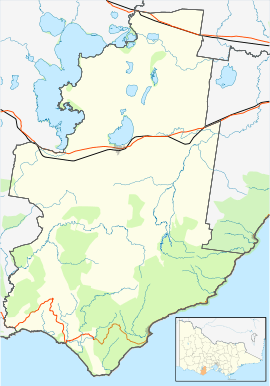
| Location | |||||||||||||
| LGA(s) | Colac Otway Shire | ||||||||||||
| State electorate(s) | Polwarth | ||||||||||||
| Federal Division(s) | Corangamite | ||||||||||||
| |||||||||||||
Wongarra is a coastal locality in the Shire of Colac Otway, Victoria, Australia.[1] In the 2011 census, the population of Wongarra was too low to separately report; however in November 2014 the Victorian Electoral Commission recorded 41 enrolled voters in Wongarra, living in 37 properties.[2][3]
The Great Ocean Road runs along the coastline through Wongarra, with Sunnyside Road the only road running inland in the area. Much of the northern area of Wongarra is either state forest or lies within the Great Otway National Park. The locality contains scenic tourist destinations Cape Patton and the Carisbrook Falls.[4][5]
A postal receiving office opened at Wongarra from 1 October 1912. Wongarra Post Office opened on 1 July 1927, and closed on 11 December 1971.[6] A part-time school, shared with one at neighbouring Skenes Creek was open by 1905, at which time it was operating out of leased premises.[7] In 1919, it was reported that the two part-time schools had an average attendance of 12.[8] The Wongarra school was made full-time in 1926, but has long since closed.[9]
The 3234 postcode, which includes Wongarra and Wye River, had the tenth-highest incomes of any in the state in 2010-11.[10] It contains the four-star Whitecrest Resort, and the Points South holiday cottages, formerly run by ex-Tour de France cyclist Phil Anderson.[11][12][13]
The well-known Otway Harvest truffle farm is located on Sunnyside Road, Wongarra. It was most recently sold in mid-2014 for over AU$2,000,000. In 2012, it reportedly sold its truffles wholesale for a price of $2,500 per kilogram.[14][15][16][17]
Surf Life Saving Australia rates the beaches along the Wongarra coastline as either highly or extremely dangerous for swimming, although they note that sections of them are popular for rock fishing. There are two surfing breaks in the area, known as "Boneyards" and "Juniors".[18][19]
The former Carisbrook Mill site, located off Sunnyside Road, is listed on the Shire of Colac Otway Heritage Inventory.[20]
References
- ↑ "Wongarra (entry 103363)". VICNAMES. Government of Victoria. Retrieved 12 January 2015.
- ↑ "2011 Census QuickStats: Wye River". Australian Bureau of Statistics. Retrieved 13 July 2014.
- ↑ "Locality Finder" (PDF). Victorian Electoral Commission. 16 June 2014. Retrieved 10 July 2014.
- ↑ "Wongarra". greatoceanroad.com. Retrieved 12 January 2015.
- ↑ "Wongarra VIC 3234". Google Maps. Retrieved 12 January 2015.
- ↑ "Wongarra". Post Office Reference. Premier Postal. Retrieved 12 January 2015.
- ↑ "HELPING COUNTRY SCHOOLS.". The Australasian. Melbourne: National Library of Australia. 1 April 1905. p. 38. Retrieved 12 January 2015.
- ↑ "COUNTRY NEWS.". Geelong Advertiser. Vic.: National Library of Australia. 31 May 1919. p. 5. Retrieved 12 January 2015.
- ↑ "COUNTRY NEWS.". The Argus. Melbourne: National Library of Australia. 10 June 1926. p. 17. Retrieved 12 January 2015.
- ↑ "At $145,000-plus incomes, Hawksburn and Toorak top Victoria's highest earning postcodes". Property Observer. 1 May 2013.
- ↑ "Resort's $1.5m facelift". The Echo. 28 October 2004.
- ↑ "Heaven for a mother superior". Herald-Sun. 30 April 2004.
- ↑ "Champ's luxury home recycled". Geelong Advertiser. 23 March 2007.
- ↑ "Landmark properties to live on". Geelong Advertiser. 4 June 2014.
- ↑ "Foraging ahead". The Australian. 27 August 2011.
- ↑ "Truffle windfall gilds this field". The Australian. 3 July 2010.
- ↑ "Hungry, nosy pig key to success". Colac Herald. 30 July 2012. Retrieved 12 January 2015.
- ↑ "Beach 371". Beachsafe. Surf Life Saving Australia. Retrieved 12 January 2015.
- ↑ "Carisbrook Creek Beach". Beachsafe. Surf Life Saving Australia. Retrieved 12 January 2015.
- ↑ "Carisbrook Mill". Retrieved 12 January 2015.