Washington State Route 21
| ||||
|---|---|---|---|---|
|
SR 21 is highlighted in red. | ||||
| Route information | ||||
| Defined by RCW 47.17.085 | ||||
| Maintained by WSDOT | ||||
| Length: | 191.34 mi[1] (307.93 km) | |||
| Existed: | 1964[2] – present | |||
| Major junctions | ||||
| South end: |
| |||
|
| ||||
| North end: |
| |||
| Location | ||||
| Counties: | Franklin, Adams, Lincoln, Ferry | |||
| Highway system | ||||
| ||||

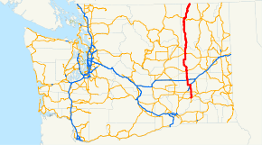
State Route 21 (SR 21) is a 191.34-mile (307.93 km) long state highway in the U.S. state of Washington that traverses four counties: Franklin, Adams, Lincoln and Ferry. The highway extends from an intersection with SR 260 in Kahlotus north through Lind, Odessa, Clark, Keller, Republic and Curlew before becoming Highway 41 (BC 41) at the Canada–US border in Danville. SR 21 is concurrent with U.S. Route 2 (US 2) in Wilbur and SR 20 in Republic and has two diamond interchanges: at US 395 in Lind and Interstate 90 (I-90) south of Odessa. Between Lincoln and Ferry counties, the roadway crosses Franklin D. Roosevelt Lake on the Keller Ferry, operated fare free by the Washington State Department of Transportation (WSDOT) and the Department of Highways (DoH) since 1930.
Since 1899, at least one segment of the current highway has been in the state highway system. In 1899, the Marble Mount Road was established and later numbered State Road 4 in 1905 and renamed to the Sans Poil-Loomis Road in 1907. In 1915, a branch to the Canada–US border was added to the highway, but was removed in 1923. In 1937, the Primary state highways were established and State Road 4 became Primary State Highway 4 (PSH 4), while the former Canadian branch became Secondary State Highway 4A (SSH 4A). Another highway, extending from Lind to Wilbur, became SSH 4B. In 1964, PSH 4 was split into SR 20 and SR 21 while SSH 2A and SSH 2B also became SR 21. In 1983, a road between Lind and Kahlotus became part of SR 21.
The Keller Ferry, which travels across the Columbia River at Franklin D. Roosevelt Lake to connect the two segments of SR 21, was originally a private cable ferry operated in the early 1890s. In 1929, the Ferry and Lincoln counties unveiled a new eight-car cable ferry, named the Keller of Seattle, which served the two counties until 1930. The state highway department took over operations of the ferry in 1930 and replaced the vessel with various boats until a permanent ferry, the Martha S., was launched in 1948. The Martha S. would go on to serve until 2013, when it was retired and relaced with the more modern MV Sanpoil.
Route description
SR 21 originates at an intersection with SR 260, about 0.28 miles (0.45 km) east of the northern terminus of SR 263;[1] both intersections are in the city of Kahlotus, which is located in a narrow valley near several coulees in Franklin County. After leaving Kahlotus as the Lind–Kahlotus Road, the highway turns northeast and later west as it passes over the Sand Hills Coulee four times. Curving due north, the roadway leaves Franklin County to enter Adams County. Passing farmland in the flat landscape, SR 21 intersects SR 26 and continues through an unnamed coulee to intersect Smart Road. Smart Road was the former alignment of SR 21 prior to the U.S. Route 395 (US 395) interchange being built. SR 21 intersects US 395 in a diamond interchange east of Downtown Lind.[3] From the interchange, the highway travels west and intersects Smart Road again before crossing over the Centennial Trail and entering Downtown Lind. In Downtown, the roadway is named Second, I and First Streets and serves as the main connector to other areas. After turning north to leave Lind, the road encounters the John Wayne Pioneer Trail and more plains before intersecting the pre-interstate alignment of Interstate 90 (I-90) and interchanging with I-90 at exit 206, another diamond interchange.[4] North of the interchange, SR 21 travels through more plains and a coulee to leave Adams County and enter Lincoln County.[5][6][7]
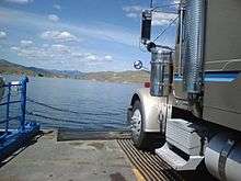
In Lincoln County, the highway travels through farmland to encounter Odessa as Division Street, intersecting SR 28. The roadway turns northwest at Pacific Lake and reverts northwards into farmland. After temporarily turning east into more farmland, the road enters Wilbur, named Bruce Avenue. In Wilbur, SR 21 turns west, concurrent with US 2, for 0.65 miles (1.05 km) before branching off north to intersect SR 174 and leave Wilbur towards dense forests. North of Wilbur, the roadway approaches Speigle Canyon and makes several turns before exiting the canyon and nearing Franklin D. Roosevelt Lake; at 80,000 acres (323.75 km2), the lake is the largest in Washington.[8][9] Paralleling the lake, the road then uses the Keller Ferry, a 80-foot (24.38 m) long boat used as a fare-free ferry across Franklin D. Roosevelt Lake, part of the Lake Roosevelt National Recreation Area, operated by the Washington State Department of Transportation (WSDOT) and its previous counterparts since 1930.[10]

The ferry travels across the Lincoln County line to enter Ferry County, named after Elisha P. Ferry, the first Washington governor,[11] southwest of Keller in the Colville Indian Reservation.[12][13] Traveling northeast, between the Sanpoil River and the southern end of the Okanagan Highlands, SR 21 passes Keller and continues inland into the Columbia Mountains on the banks of the river. The river forms a canyon that the highway passes through and eventually both the river and road leave the Colville Indian Reservation. Shortly after leaving the reservation, the roadway enters Republic and becomes concurrent with SR 20 for 2.56 miles (4.12 km) before exiting the concurrency and Republic. Between Republic and the Canada–US border, an estimated daily average of 1,600 motorists used this segment of SR 21, making this section the busiest. The daily average has declined since 2006 and 2007, when a daily average of 1,700 motorists utilized the segment.[14][15][16] Northeast of Republic, the highway passes Curlew Lake, the 123-acre (0.50 km2) Curlew Lake State Park and the communities of Malo and Curlew.[17][18] After passing through more dense forests, the roadway enters Danville, where SR 21 crosses the Canada–US border into British Columbia as Highway 41 (BC 41).[5][6][7] BC 41 continues 1.2 kilometres (0.7 mi) north to end at BC 3 southwest of Grand Forks, BC.[19]
History

SR 21 originated as the Marble Mount Road that extended from the north end of the Keller Ferry to Republic and was established in 1899.[20][21] The Marble Mount Road was later numbered State Road 4 in 1905 and renamed to the Sans Poil-Loomis Road in 1907.[22][23] An extension of State Road 4 from Republic to the Canada–US border existed from 1915 until 1923.[24][25] When the Primary and secondary highway system was established in 1937, Primary State Highway 4 (PSH 4) replaced State Road 4 and was extended south from the Keller Ferry to Wilbur. The Canada–US border branch of State Road 4 that was deleted in 1923 was re-added as Secondary State Highway 4A (SSH 4A) and a highway extending south from Wilbur to Lind became SSH 2B.[26] All three roadways were later combined as SR 21 in a highway renumbering in 1964.[2][27] In 1983, SR 21 was extended south to SR 260 in Kahlotus.[2] Since 1983, the road has not been realigned with the exception of the U.S. Route 395 (US 395) interchange in Lind.[7] The speed limit between Curlew Lake State Park and the community of the same name was temporarily lowered on March 9, 2009 to 35 miles per hour (56 km/h) due to cracks in the pavement.[28] The speed limit was restored to 55 miles per hour (89 km/h) on March 9.[29]
Keller Ferry history

The Keller Ferry connects SR 21 between Lincoln and Ferry counties, which are separated by Franklin D. Roosevelt Lake. The ferry originated as an oar-propelled canoe that was used by Native Americans prior to the late 19th century. In the early 1890s a four-car cable ferry, owned and operated by Todd Clark and William Robertson, was established. After the town of Keller was established north / upriver on the Sanpoil River in 1898, J.C. Keller, the founder of the town, purchased the cable ferry in 1899.[30][31] In 1925, Lincoln and Ferry counties jointly purchased Keller's ferry and in 1929 replaced the original ferry with an eight-car cable ferry that was later named Keller of Seattle.[30][31] The Department of Highways (DoH), the predecessor to the modern-day Washington State Department of Transportation (WSDOT), purchased the ferry on September 1, 1930 and ran it toll-free as it is today.[10][30] The original location of the ferry was flooded between 1939 and 1940 after the damming of the Grand Coulee Dam west / downriver on the Columbia River created Franklin D. Roosevelt Lake. In July 1939, the L.A. McLeod was launched and replaced the earlier cable ferries.[32] Between 1944 and 1948, the Ann of Wilbur, a tug boat, tugged the Sanpoil barge that was used as a temporary replacement for the McLeod.[33] On September 9, 1948, the Martha S. was launched and has been in continual operation since.[34] Since the Martha S. is over seventy years old, the United States Coast Guard requires that the ferry undergo a full drydock inspection every five years.[33] As of 2009, WSDOT is $5.5 million US$ short of being able to replace the ferry. Design work has already been completed, but the ferry is not expected to be replaced yet.[35][36] The Keller Ferry was repaired on February 15, 2007 to expand its lifespan; WSDOT detoured traffic onto SR 174.[37] The Martha S. had a leak that was discovered in October 2009 and is suspended. Traffic has been detoured onto other highways.[38][39] Ferry service resumed on October 19,[40][41] but one of the two engines overheated on October 26, only one week later, needing to be replaced, thus shutting down the ferry a second time during the same month.[42] Due to the prohibitive cost of having to specially manufacture many replacement parts, the Martha S was retired in July 2013, and replaced shortly thereafter with the new M/V Sanpoil, which is now the vessel serving the Keller Ferry run.
Major intersections
| County | Location | mi[1] | km | Destinations | Notes |
|---|---|---|---|---|---|
| Franklin | Kahlotus | 0.00 | 0.00 | Southern terminus | |
| Adams | | 11.64 | 18.73 | ||
| | 22.14 | 35.63 | Smart Road | Former SR 21 | |
| Lind | 24.48 | 39.40 | Interchange | ||
| 25.42 | 40.91 | Smart Road / Airport Road | Former SR 21 | ||
| | 37.32 | 60.06 | Old SR 90 | ||
| | 37.80 | 60.83 | Interchange | ||
| Lincoln | Odessa | 55.83 | 89.85 | ||
| Wilbur | 91.73 | 147.63 | |||
| 92.38 | 148.67 | Northern end of US concurrency | |||
| 92.90 | 149.51 | ||||
| Franklin D. Roosevelt Lake | 106.60 | 171.56 | Keller Ferry | ||
| Ferry | Republic | 160.05 | 257.58 | Southern end of SR 20 concurrency | |
| 162.61 | 261.70 | Northern end of SR 20 concurrency | |||
| | 191.34 | 307.93 | Northern terminus Canada–United States border | ||
| 1.000 mi = 1.609 km; 1.000 km = 0.621 mi | |||||
References
- 1 2 3 Washington State Department of Transportation (2008). "State Highway Log: Planning Report, SR 2 to SR 971" (PDF). Retrieved August 13, 2009.
- 1 2 3 Washington State Legislature (1970). "RCW 47.17.085: State route No. 21". Retrieved August 13, 2009.
- ↑ Washington State Department of Transportation (October 2, 2004). "SR 395; Junction SR 21" (PDF). Retrieved August 13, 2009.
- ↑ Washington State Department of Transportation (October 2, 2001). "SR 90 – Exit 206; Junction SR 21" (PDF). Retrieved August 13, 2009.
- 1 2 Google (August 13, 2009). "State Route 21" (Map). Google Maps. Google. Retrieved August 13, 2009.
- 1 2 Pacific Northwest: Washington, Oregon, Western Idaho, Southwestern British Columbia (Map) (6th ed.). 1 inch = 7.5 miles. The Thomas Guide. Cartography by NAVTEQ. Thomas Bros., Rand McNally. 2004. pp. 105, 113, 121. ISBN 0-528-99511-1.
- 1 2 3 Washington State Highways, 2008–2009 (PDF) (Map) (2008–09 ed.). 1:842,000. Cartography by United States Geological Survey. Washington State Department of Transportation. 2008. § B7, C7, D7, E7, F7. Retrieved August 13, 2009.
- ↑ National Park Service (2008). "Lake Roosevelt NRA: The Story of the Columbia Basin Project (Data on the Dam and Project)". Retrieved August 13, 2009.
- ↑ United States Geological Survey (December 31, 1992). "Feature Detail Report for: Franklin D Roosevelt Lake". Retrieved August 13, 2009.
- 1 2 Washington State Department of Transportation. "State Ferries in Eastern Washington". Retrieved August 13, 2009.
- ↑ Meany, Edmond Stephen (1915). Governors of Washington, Territorial and State. Seattle: University of Washington Department of Printing. Retrieved August 14, 2009.
- ↑ Lake Roosevelt National Recreation Area (PDF) (Map). National Park Service. 2009. Retrieved August 13, 2009.
- ↑ Location (Map). Confederated Tribes of the Colville Reservation. 2000. Retrieved August 13, 2009.
- ↑ Washington State Department of Transportation (2008). "2008 Annual Traffic Report" (PDF). Retrieved August 13, 2009.
- ↑ Washington State Department of Transportation (2007). "2007 Annual Traffic Report" (PDF). Retrieved August 13, 2009.
- ↑ Washington State Department of Transportation (2006). "2006 Annual Traffic Report" (PDF). Retrieved August 13, 2009.
- ↑ Washington State Parks (2009). "Curlew Lake State Park". Retrieved August 13, 2009.
- ↑ Washington State Tourism. "Republic, Washington: Curlew State Park". Retrieved August 13, 2009.
- ↑ Google (August 13, 2009). "BC Highway 41" (Map). Google Maps. Google. Retrieved August 13, 2009.
- ↑ Washington State Department of Transportation (1895–1935). "State Roads As Established by the Legislature, 1893 to 1935" (PDF). p. 5. Archived from the original (PDF) on November 6, 2005. Retrieved August 13, 2009.
- ↑ Washington State Legislature (March 14, 1899). "Chapter 123". Session Laws of the State of Washington. Session Laws of the State of Washington (1899 ed.). Olympia, Washington: Washington State Legislature. p. 411. Retrieved August 13, 2009.
An act providing for a state wagon road beginning at the nearest practicable point at the mouth of the Sans Foil creek in Ferry county; thence in a northerly direction up the Sans Foil creek by the most feasible and practicable route to the town of Republic; thence in a westerly direction to the Okanogan river at a point about one mile north of and opposite the mouth of Johnson creek in Okanogan county; thence in a westerly direction along the state road as heretofore laid out and established from a point about three miles south of Best's ranch on Bonaparte creek to the east bank of the Methow river; thence across said Methow river at the most practicable bridge site near the mouth of the Twisp river, to be selected ; thence in a westerly direction over the road already laid out and established across the Twisp pass to the bridge on Bridge creek near the mouth of said creek; thence in a southeasterly direction to Stehekin landing, at the mouth of the Stehekin river at the head of Lake Chelan ; thence from the bridge near the mouth of Bridge creek in a westerly direction over and across the summit of the Cascade mountains, as said road has hereto-fore been laid out and established, to a point on the Skagit river opposite the town of Marble Mount, in Skagit county, making an appropriation therefor, creating a road commission, and declaring an emergency.—Approved March 14, 1899
- ↑ Washington State Legislature (January 24, 1905). "Chapter 7: Providing for the Establishment and Repair of Certain State Highways". Session Laws of the State of Washington. Session Laws of the State of Washington (1905 ed.). Olympia, Washington: Washington State Legislature. p. 21. Retrieved August 13, 2009.
For building and repair of a State road and bridges in Ferry and Okanogan Counties, as follows, to-wit: Beginning at the mouth of the Sans Foil creek on the Columbia Counties. river, thence up said creek to the City of Republic in Ferry County, Washington, and thence from said City of Republic to the town of Loomis, in Okanogan County, Washington, the sum of $6,000.
- ↑ Washington State Legislature (March 13, 1907). "Chapter 151: Providing for the Establishment, Construction and Maintenance of State Roads and Making Appropriations for Certain State Roads". Session Laws of the State of Washington. Session Laws of the State of Washington (1907 ed.). Olympia, Washington: Washington State Legislature. p. 310. Retrieved August 13, 2009.
State Road No. 4, or the Sans Poil-Loomis Road: This road shall begin at the mouth of the Sans Poil creek on the Columbia river, and run thence as nearly as practicable over the present road to the city of Republic in Ferry county, Washington, and thence from said city of Republic over the present traveled road as nearly as may be practicable to the town of Loomis, in Okanogan county, Washington.
- ↑ Washington State Legislature (March 19, 1915). "Chapter 164: Classification of Highways". Session Laws of the State of Washington. Session Laws of the State of Washington (1915 ed.). Olympia, Washington: Washington State Legislature. pp. 488–489. Retrieved August 13, 2009.
Section 5901d. A secondary state highway is established as follows: Kettle river extension of state road No. 4: This road shall begin at the city of Republic in Ferry county and run thence by the most feasible route to Curlew in said county; thence by the most feasible route along the east river bank of Kettle river to the international boundary line near the town of Ferry.
- ↑ Washington State Legislature (March 19, 1923). "Chapter 185: Primary and Secondary State Highways". Session Laws of the State of Washington. Session Laws of the State of Washington (1923 ed.). Olympia, Washington: Washington State Legislature. p. 631. Retrieved August 13, 2009.
SEC. 14. A secondary state highway, to be known as State Road No. 4 or the Tonasket-San Poil Highway, is established as follows: Beginning at the city of Wilbur in Lincoln County; thence by the most feasible route in a northerly direction to Republic in Ferry County; thence in a westerly direction to Tonasket in Okanogan County.
- ↑ Washington State Legislature (March 17–18, 1937). "Chapter 190: Establishment of Primary State Highways; Chapter 207: Classification of Public Highways". Session Laws of the State of Washington. Session Laws of the State of Washington (1937 ed.). Olympia, Washington: Washington State Legislature. pp. 935; 1002. Retrieved August 13, 2009.
SEC. 4. A primary state highway to be known as Primary State Highway No. 4, or the Tonasket-San Poil Highway, is hereby established according to description as follows: Beginning at Wilbur on Primary State Highway No. 2, thence in a northerly direction by the most feasible route to Republic, thence in a westerly direction by the most feasible route by way of Tonasket to a junction with Primary State Highway No. 10; (a) Secondary State Highway No. 4A; beginning at Republic on Primary State Highway No. 4, thence in a northeasterly direction by the most feasible route to the east of Curlew Lake by way of Curlew to the international boundary line in the vicinity of Danville; (b) Secondary State Highway No. 4B; beginning at a junction of Primary State Highways Nos. 4 and 2 in the vicinity west of Wilbur, thence in a southerly direction by the most feasible route by way of Odessa to a junction with Primary State Highway No. 11 in the vicinity of Lind.
- ↑ C. G. Prahl (December 1, 1965). "Identification of State Highways" (PDF). Washington State Highway Commission, Department of Highways. Retrieved August 13, 2009.
- ↑ "Speed restrictions to affect traffic on State Route 21 in Ferry County" (Press release). Washington State Department of Transportation. March 5, 2009. Retrieved August 15, 2009.
- ↑ "SR 21-Speed limit back to normal on State Route 21 in Ferry County" (Press release). Washington State Department of Transportation. March 30, 2009. Retrieved August 15, 2009.
- 1 2 3 Becker, Paula (January 26, 2005). "Ferry and Lincoln counties purchase the Keller Ferry concession in 1925.". HistoryLink. Retrieved August 13, 2009.
- 1 2 Register staff (August 17, 1962). "'Martha S' Has Ancestors Dating Back to the Late 1800's". The Wilbur Register.
- ↑ Becker, Paula (January 26, 2005). "Original Keller Ferry site floods as the Columbia River rises behind the newly constructed Grand Coulee Dam in the winter of 1939/1940.". HistoryLink. Retrieved August 13, 2009.
- 1 2 Washington State Department of Transportation (2002). "Keller Ferry Historical Photos". Retrieved August 13, 2009.
- ↑ Becker, Paula (January 26, 2005). "Washington State Ferry Martha S. of Keller makes her maiden voyage across Lake Roosevelt on September 9, 1948.". HistoryLink. Retrieved August 13, 2009.
- ↑ Washington State Department of Transportation (2002). "SR 21 – Keller Ferry Replacement". Retrieved August 13, 2009.
- ↑ SR 21 – Keller Ferry Replacement (Map). Washington State Department of Transportation. 2002. Retrieved August 13, 2009.
- ↑ "SR 21 Keller Ferry Repairs scheduled" (Press release). Washington State Department of Transportation. February 8, 2007. Retrieved August 15, 2009.
- ↑ "Keller Ferry service across Columbia River suspended until further notice" (Press release). Washington State Department of Transportation. October 8, 2009. Retrieved October 9, 2009.
- ↑ Sowa, Tom (October 9, 2009). "Keller Ferry across Columbia River shut down". The Spokesman-Review. Retrieved October 9, 2009.
- ↑ "Keller Ferry back in service by noon Monday, October 19" (Press release). Washington State Department of Transportation. October 19, 2009. Retrieved October 28, 2009.
- ↑ "Keller Ferry to resume runs on Monday". The Seattle Times. October 19, 2009. Retrieved October 28, 2009.
- ↑ "Keller Ferry service to be interrupted for repairs" (Press release). Washington State Department of Transportation. October 26, 2009. Retrieved October 28, 2009.
External links
| Wikimedia Commons has media related to Washington State Route 21. |