Warrington Township, York County, Pennsylvania
| Warrington Township, York County, Pennsylvania | |
|---|---|
| Township | |
|
Gifford Pinchot State Park is in Warrington Township | |
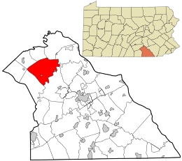 Location in York County and the state of Pennsylvania. | |
| Country | United States |
| State | Pennsylvania |
| County | York |
| Settled | 1735 |
| Incorporated | 1744 |
| Government | |
| • Type | Board of Supervisors |
| Area | |
| • Total | 36.0 sq mi (93 km2) |
| • Land | 35.4 sq mi (92 km2) |
| • Water | 0.6 sq mi (2 km2) |
| Population (2010) | |
| • Total | 4,532 |
| • Density | 130/sq mi (49/km2) |
| Time zone | Eastern (EST) (UTC-5) |
| • Summer (DST) | EDT (UTC-4) |
| Area code(s) | 717 |

Warrington Township is a township in York County, Pennsylvania, USA. The population was 4,532 at the 2010 census.[1] The township is named after Warrington, England, like many townships having English names in York County. Others dispute the origin, believing it may be named after Waringstown, County Down, Ireland.[2]
History
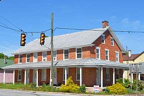
The Warrington Meetinghouse was added to the National Register of Historic Places in 1975.[3]
Geography
According to the United States Census Bureau, the township has a total area of 36.0 square miles (93 km2), of which 35.4 square miles (92 km2) is land and 0.6 square miles (1.6 km2), or 1.75%, is water. The township completely surrounds the borough of Wellsville.
Demographics
As of the census[4] of 2000, there were 4,435 people, 1,702 households, and 1,329 families residing in the township. The population density was 125.4 people per square mile (48.4/km²). There were 1,766 housing units at an average density of 49.9/sq mi (19.3/km²). The racial makeup of the township was 98.47% White, 0.23% African American, 0.11% Native American, 0.43% Asian, 0.07% from other races, and 0.70% from two or more races. Hispanic or Latino of any race were 1.04% of the population.
There were 1,702 households out of which 32.6% had children under the age of 18 living with them, 67.9% were married couples living together, 6.3% had a female householder with no husband present, and 21.9% were non-families. 16.2% of all households were made up of individuals and 5.1% had someone living alone who was 65 years of age or older. The average household size was 2.59 and the average family size was 2.89.
In the township the population was spread out with 23.8% under the age of 18, 6.6% from 18 to 24, 30.9% from 25 to 44, 29.3% from 45 to 64, and 9.4% who were 65 years of age or older. The median age was 40 years. For every 100 females there were 99.5 males. For every 100 females age 18 and over, there were 101.4 males.
The median income for a household in the township was $47,425, and the median income for a family was $51,941. Males had a median income of $37,940 versus $26,203 for females. The per capita income for the township was $21,368. About 1.5% of families and 2.6% of the population were below the poverty line, including 0.5% of those under age 18 and 5.2% of those age 65 or over.
References
- ↑ "Race, Hispanic or Latino, Age, and Housing Occupancy: 2010 Census Redistricting Data (Public Law 94-171) Summary File (QT-PL), Warrington township, York County, Pennsylvania". U.S. Census Bureau, American FactFinder 2. Retrieved October 17, 2011.
- ↑ From Rostrevor to Raphoe An Overview of Ulster Place-Names in Pennsylvania 1700-1820
- ↑ National Park Service (2010-07-09). "National Register Information System". National Register of Historic Places. National Park Service.
- ↑ "American FactFinder". United States Census Bureau. Retrieved 2008-01-31.
External links
Coordinates: 40°05′00″N 76°56′59″W / 40.08333°N 76.94972°W