Shrewsbury, Pennsylvania
| Shrewsbury | |
|---|---|
| Borough | |
|
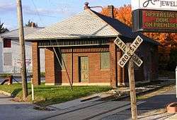
Rail station at Shrewsbury | |
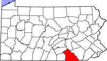
 Location in York County and the state of Pennsylvania. | |
| Coordinates: 39°46′02″N 76°40′44″W / 39.76722°N 76.67889°WCoordinates: 39°46′02″N 76°40′44″W / 39.76722°N 76.67889°W | |
| Country | United States |
| State | Pennsylvania |
| County | York |
| Settled | 1800 |
| Incorporated | 1834 |
| Government | |
| • Type | Borough Council |
| Area | |
| • Total | 1.8 sq mi (5 km2) |
| Elevation | 994 ft (303 m) |
| Population (2010) | |
| • Total | 3,823 |
| • Density | 2,100/sq mi (820/km2) |
| Time zone | Eastern (EST) (UTC-5) |
| • Summer (DST) | EDT (UTC-4) |
| Zip code | 17361 |
| Area code(s) | 717 |
Shrewsbury is a borough in York County, Pennsylvania, United States. The population was 3,823 at the 2010 census.[1]
History
The Shrewsbury Historic District was listed on the National Register of Historic Places in 1984.[2]
Geography
Shrewsbury is located at 39°46′2″N 76°40′44″W / 39.76722°N 76.67889°W (39.767127, -76.678965).[3]
According to the United States Census Bureau, the borough has a total area of 1.8 square miles (4.7 km2), all land.
Demographics
| Historical population | |||
|---|---|---|---|
| Census | Pop. | %± | |
| 1840 | 340 | — | |
| 1850 | 472 | 38.8% | |
| 1860 | 552 | 16.9% | |
| 1870 | 600 | 8.7% | |
| 1880 | 565 | −5.8% | |
| 1890 | 562 | −0.5% | |
| 1900 | 554 | −1.4% | |
| 1910 | 598 | 7.9% | |
| 1920 | 568 | −5.0% | |
| 1930 | 671 | 18.1% | |
| 1940 | 720 | 7.3% | |
| 1950 | 787 | 9.3% | |
| 1960 | 943 | 19.8% | |
| 1970 | 1,716 | 82.0% | |
| 1980 | 2,688 | 56.6% | |
| 1990 | 2,672 | −0.6% | |
| 2000 | 3,378 | 26.4% | |
| 2010 | 3,823 | 13.2% | |
| Est. 2015 | 3,863 | [4] | 1.0% |
| Sources:[5][6][7] | |||
As of the census[6] of 2000, there were 3,378 people, 1,330 households, and 942 families residing in the borough. The population density was 1,916.4 people per square mile (741.1/km²). There were 1,367 housing units at an average density of 775.5 per square mile (299.9/km²). The racial makeup of the borough was 97.48% White, 0.80% African American, 0.15% Native American, 0.77% Asian, 0.15% Pacific Islander, 0.27% from other races, and 0.38% from two or more races. Hispanic or Latino of any race were 0.98% of the population.
There were 1,330 households out of which 32.3% had children under the age of 18 living with them, 61.4% were married couples living together, 7.1% had a female householder with no husband present, and 29.1% were non-families. 26.1% of all households were made up of individuals and 14.6% had someone living alone who was 65 years of age or older. The average household size was 2.54 and the average family size was 3.08.
In the borough the population was spread out with 25.7% under the age of 18, 6.0% from 18 to 24, 28.5% from 25 to 44, 26.2% from 45 to 64, and 13.6% who were 65 years of age or older. The median age was 40 years. For every 100 females there were 92.5 males. For every 100 females age 18 and over, there were 88.7 males.
The median income for a household in the borough was $49,983, and the median income for a family was $57,358. Males had a median income of $39,107 versus $32,196 for females. The per capita income for the borough was $20,292. About 2.4% of families and 4.7% of the population were below the poverty line, including 1.5% of those under age 18 and 15.2% of those age 65 or over.
Due to the lower cost of real estate compared to neighboring Maryland, Shrewsbury is beginning to become a popular relocation destination for residents of the Baltimore and even Washington, DC metropolitan areas.
References
- ↑ "Race, Hispanic or Latino, Age, and Housing Occupancy: 2010 Census Redistricting Data (Public Law 94-171) Summary File (QT-PL), Shrewsbury borough, Pennsylvania". U.S. Census Bureau, American FactFinder 2. Retrieved October 6, 2011.
- ↑ National Park Service (2010-07-09). "National Register Information System". National Register of Historic Places. National Park Service.
- ↑ "US Gazetteer files: 2010, 2000, and 1990". United States Census Bureau. 2011-02-12. Retrieved 2011-04-23.
- ↑ "Annual Estimates of the Resident Population for Incorporated Places: April 1, 2010 to July 1, 2015". Retrieved July 2, 2016.
- ↑ "Census of Population and Housing". U.S. Census Bureau. Archived from the original on May 11, 2015. Retrieved 11 December 2013.
- 1 2 "American FactFinder". United States Census Bureau. Retrieved 2008-01-31.
- ↑ "Incorporated Places and Minor Civil Divisions Datasets: Subcounty Resident Population Estimates: April 1, 2010 to July 1, 2012". Population Estimates. U.S. Census Bureau. Archived from the original on June 17, 2013. Retrieved 11 December 2013.
External links
 Shrewsbury, Pennsylvania travel guide from Wikivoyage