Stonybrook, Pennsylvania
| Stonybrook | |
|---|---|
| CDP | |
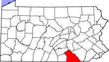
 Location in York County and the state of Pennsylvania. | |
| Coordinates: 39°58′48″N 76°37′54″W / 39.98000°N 76.63167°WCoordinates: 39°58′48″N 76°37′54″W / 39.98000°N 76.63167°W | |
| Country | United States |
| State | Pennsylvania |
| County | York |
| Township | Springettsbury |
| Area | |
| • Total | 1.6 sq mi (4.2 km2) |
| • Land | 1.6 sq mi (4.2 km2) |
| Population (2010) | |
| • Total | 2,384 |
| • Density | 1,500/sq mi (570/km2) |
| Time zone | Eastern (EST) (UTC-5) |
| • Summer (DST) | EDT (UTC-4) |
Stonybrook is a census-designated place (CDP) in York County, Pennsylvania, United States. The population was 2,384 at the 2010 census.[1] The area was delineated as the Stonybrook-Wilshire CDP for the 2000 census.
Geography
Stonybrook is located at 39°58′48″N 76°37′54″W / 39.98000°N 76.63167°W (39.9799, -76.6317)[2] in Springettsbury Township, east of York.
According to the United States Census Bureau, the CDP has a total area of 1.6 square miles (4.1 km2), all of it land.
References
- ↑ "Race, Hispanic or Latino, Age, and Housing Occupancy: 2010 Census Redistricting Data (Public Law 94-171) Summary File (QT-PL), Stonybrook CDP, Pennsylvania". U.S. Census Bureau, American FactFinder 2. Retrieved October 18, 2011.
- ↑ "US Gazetteer files: 2010, 2000, and 1990". United States Census Bureau. 2011-02-12. Retrieved 2011-04-23.
This article is issued from Wikipedia - version of the 8/28/2016. The text is available under the Creative Commons Attribution/Share Alike but additional terms may apply for the media files.