Shrewsbury Township, York County, Pennsylvania
| Shrewsbury Township, York County, Pennsylvania | |
|---|---|
| Township | |
|
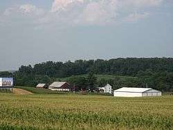
A farm just off Interstate 83 in Shrewsbury Township | |
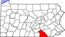
 Location in York County and the state of Pennsylvania. | |
| Country | United States |
| State | Pennsylvania |
| County | York |
| Settled | 1739 |
| Incorporated | 1742 |
| Government | |
| • Type | Board of Supervisors |
| Area | |
| • Total | 29.2 sq mi (76 km2) |
| Population (2010) | |
| • Total | 6,447 |
| • Density | 203.4/sq mi (78.5/km2) |
| Time zone | Eastern (EST) (UTC-5) |
| • Summer (DST) | EDT (UTC-4) |
| Area code(s) | 717 |
Shrewsbury Township is a township in York County, Pennsylvania, United States. The population was 6,447 at the 2010 census.[1]
History
The Fissel's School, Bridge 634, Northern Central Railway, Bridge 182+42, Northern Central Railway, and Stone Arch Road Bridge, Stewartstown Railroad are listed on the National Register of Historic Places.[2]
Geography
According to the United States Census Bureau, the township has a total area of 29.2 square miles (76 km2), of which 0.03% is water. The township is located in southern York County adjacent to the Maryland-Pennsylvania border and along Interstate 83, between York to the north and Baltimore to the south. Shrewsbury Township surrounds the boroughs of Shrewsbury, Glen Rock, Railroad, and New Freedom.
Demographics
As of the census[3] of 2000, there were 5,947 people, 2,157 households, and 1,729 families residing in the township. The population density was 203.4 people per square mile (78.5/km²). There were 2,206 housing units at an average density of 75.4/sq mi (29.1/km²). The racial makeup of the township was 98.52% White, 0.30% African American, 0.03% Native American, 0.45% Asian, 0.20% from other races, and 0.49% from two or more races. Hispanic or Latino of any race were 0.92% of the population.
There were 2,157 households out of which 33.8% had children under the age of 18 living with them, 71.3% were married couples living together, 5.2% had a female householder with no husband present, and 19.8% were non-families. 16.8% of all households were made up of individuals and 7.9% had someone living alone who was 65 years of age or older. The average household size was 2.71 and the average family size was 3.04.
In the township the population was spread out with 24.5% under the age of 18, 5.7% from 18 to 24, 25.4% from 25 to 44, 31.0% from 45 to 64, and 13.4% who were 65 years of age or older. The median age was 42 years. For every 100 females there were 98.6 males. For every 100 females age 18 and over, there were 96.8 males.
The median income for a household in the township was $58,191, and the median income for a family was $65,966. Males had a median income of $40,038 versus $30,391 for females. The per capita income for the township was $24,841. About 2.2% of families and 3.8% of the population were below the poverty line, including 5.0% of those under age 18 and 1.9% of those age 65 or over.
References
- ↑ "Race, Hispanic or Latino, Age, and Housing Occupancy: 2010 Census Redistricting Data (Public Law 94-171) Summary File (QT-PL), Shrewsbury township, York County, Pennsylvania". U.S. Census Bureau, American FactFinder 2. Retrieved October 17, 2011.
- ↑ National Park Service (2010-07-09). "National Register Information System". National Register of Historic Places. National Park Service.
- ↑ "American FactFinder". United States Census Bureau. Retrieved 2008-01-31.
External links
Coordinates: 39°44′00″N 76°45′05″W / 39.73333°N 76.75139°W