Walcott, Wyoming
| Walcott, Wyoming | |
|---|---|
| Unincorporated community | |
 Walcott, Wyoming  Walcott, Wyoming Location within the state of Wyoming | |
| Coordinates: 41°45′40″N 106°50′42″W / 41.76111°N 106.84500°WCoordinates: 41°45′40″N 106°50′42″W / 41.76111°N 106.84500°W | |
| Country | United States |
| State | Wyoming |
| County | Carbon |
| Elevation | 6,627 ft (2,020 m) |
| Time zone | Mountain (MST) (UTC-7) |
| • Summer (DST) | MDT (UTC-6) |
| ZIP codes | 82335 |
| GNIS feature ID | 1595988[1] |
Walcott is an unincorporated community in central Carbon County, Wyoming, United States. It lies along local roads near Interstate 80 and the concurrent U.S. Routes 30 and 287, east of the city of Rawlins, the county seat of Carbon County.[2] Its elevation is 6,627 feet (2,020 m).[1] Although Walcott is unincorporated, it had a post office, with the ZIP code of 82335 that closed in 2007.[3]
Public education in the community of Walcott is provided by Carbon County School District #2.
References
- 1 2 "Walcott, Wyoming". Geographic Names Information System. United States Geological Survey.
- ↑ Rand McNally. The Road Atlas '08. Chicago: Rand McNally, 2008, p. 116.
- ↑ http://about.usps.com/who-we-are/postmasterfinder/welcome.htm
Municipalities and communities of Carbon County, Wyoming, United States | ||
|---|---|---|
| Cities | 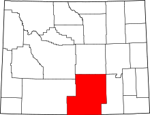 | |
| Towns | ||
| CDPs | ||
| Unincorporated communities | ||
| Ghost towns | ||
This article is issued from Wikipedia - version of the 8/8/2016. The text is available under the Creative Commons Attribution/Share Alike but additional terms may apply for the media files.