Baggs, Wyoming
| Baggs, Wyoming | |
|---|---|
| Town | |
|
Entering Baggs from the south on Wyoming State Highway 789. | |
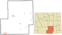 Location in Carbon County and the state of Wyoming. | |
 Baggs, Wyoming Location in the United States | |
| Coordinates: 41°2′8″N 107°39′27″W / 41.03556°N 107.65750°WCoordinates: 41°2′8″N 107°39′27″W / 41.03556°N 107.65750°W | |
| Country | United States |
| State | Wyoming |
| County | Carbon |
| Area[1] | |
| • Total | 0.51 sq mi (1.32 km2) |
| • Land | 0.51 sq mi (1.32 km2) |
| • Water | 0 sq mi (0 km2) |
| Elevation | 6,247 ft (1,904 m) |
| Population (2010)[2] | |
| • Total | 440 |
| • Estimate (2012[3]) | 437 |
| • Density | 862.7/sq mi (333.1/km2) |
| Time zone | Mountain (MST) (UTC-7) |
| • Summer (DST) | MDT (UTC-6) |
| ZIP code | 82321 |
| Area code(s) | 307 |
| FIPS code | 56-04740[4] |
| GNIS feature ID | 1585049[5] |

Baggs is a town in Carbon County, Wyoming, United States. The population was 440 at the 2010 census.
Geography
Baggs is located at 41°2′8″N 107°39′27″W / 41.03556°N 107.65750°W (41.035575, -107.657399).[6]
According to the United States Census Bureau, the town has a total area of 0.51 square miles (1.32 km2), all of it land.[1]
Demographics
| Historical population | |||
|---|---|---|---|
| Census | Pop. | %± | |
| 1920 | 200 | — | |
| 1930 | 192 | −4.0% | |
| 1940 | 221 | 15.1% | |
| 1950 | 206 | −6.8% | |
| 1960 | 199 | −3.4% | |
| 1970 | 146 | −26.6% | |
| 1980 | 433 | 196.6% | |
| 1990 | 272 | −37.2% | |
| 2000 | 348 | 27.9% | |
| 2010 | 440 | 26.4% | |
| Est. 2015 | 431 | [7] | −2.0% |
2010 census
As of the census[2] of 2010, there were 440 people, 183 households, and 114 families residing in the town. The population density was 862.7 inhabitants per square mile (333.1/km2). There were 223 housing units at an average density of 437.3 per square mile (168.8/km2). The ethnic makeup of the town was 94.1% White, 0.5% Native American, 0.2% Asian, 4.8% from other races, and 0.5% from two or more ethnic groups. Hispanic or Latino of any ethnic groups were 11.4% of the population.
There were 183 households of which 34.4% had children under the age of 18 living with them, 49.7% were married couples living together, 7.7% had a female householder with no husband present, 4.9% had a male householder with no wife present, and 37.7% were non-families. 30.1% of all households were made up of individuals and 7.7% had someone living alone who was 65 years of age or older. The average household size was 2.40 and the average family size was 3.01.
The median age in the town was 34.3 years. 27% of residents were under the age of 18; 8.5% were between the ages of 18 and 24; 25.9% were from 25 to 44; 28.2% were from 45 to 64; and 10.5% were 65 years of age or older. The gender makeup of the town was 52.7% male and 47.3% female.
2000 census
As of the census[4] of 2000, there were 348 people, 147 households, and 88 families residing in the town. The population density was 705.8 people per square mile (274.2/km²). There were 197 housing units at an average density of 399.6 per square mile (155.2/km²). The racial makeup of the town was 94.83% White, 2.59% Native American, 0.29% Asian, 1.72% from other races, and 0.57% from two or more races. Hispanic or Latino of any race were 5.17% of the population.
There were 147 households out of which 32.0% had children under the age of 18 living with them, 44.9% were married couples living together, 9.5% had a female householder with no husband present, and 40.1% were non-families. 29.3% of all households were made up of individuals and 10.9% had someone living alone who was 65 years of age or older. The average household size was 2.37 and the average family size was 2.97.
In the town the population was spread out with 26.1% under the age of 18, 6.3% from 18 to 24, 31.0% from 25 to 44, 25.6% from 45 to 64, and 10.9% who were 65 years of age or older. The median age was 39 years. For every 100 females there were 112.2 males. For every 100 females age 18 and over, there were 100.8 males.
The median income for a household in the town was $29,688, and the median income for a family was $38,250. Males had a median income of $32,031 versus $21,250 for females. The per capita income for the town was $20,812. About 7.9% of families and 14.9% of the population were below the poverty line, including 8.4% of those under age 18 and 10.8% of those age 65 or over.
Climate
This climatic region is typified by large seasonal temperature differences, with warm to hot (and often humid) summers and cold (sometimes severely cold) winters. According to the Köppen Climate Classification system, Baggs has a humid continental climate, abbreviated "Dfb" on climate maps.[9]
| Climate data for Baggs, Wyoming | |||||||||||||
|---|---|---|---|---|---|---|---|---|---|---|---|---|---|
| Month | Jan | Feb | Mar | Apr | May | Jun | Jul | Aug | Sep | Oct | Nov | Dec | Year |
| Average high °C (°F) | 0 (32) |
2 (36) |
8 (47) |
14 (58) |
20 (68) |
26 (79) |
30 (86) |
28 (83) |
23 (74) |
16 (60) |
6 (43) |
1 (33) |
14 (58) |
| Average low °C (°F) | −15 (5) |
−13 (9) |
−6 (21) |
−2 (28) |
2 (35) |
6 (42) |
9 (48) |
8 (47) |
3 (38) |
−2 (28) |
−8 (17) |
−14 (7) |
−3 (27) |
| Average precipitation mm (inches) | 10 (0.4) |
10 (0.4) |
13 (0.5) |
20 (0.8) |
36 (1.4) |
23 (0.9) |
30 (1) |
23 (0.9) |
30 (1.2) |
33 (1.3) |
15 (0.6) |
15 (0.6) |
257 (10.1) |
| Source: Weatherbase [10] | |||||||||||||
Education
Public education in the town of Baggs is provided by Carbon County School District #1. Little Snake River Valley School, a K-12 campus, serves the town.
See also
References
- 1 2 "US Gazetteer files 2010". United States Census Bureau. Archived from the original on 2012-01-24. Retrieved 2012-12-14.
- 1 2 "American FactFinder". United States Census Bureau. Retrieved 2012-12-14.
- ↑ "Population Estimates". United States Census Bureau. Archived from the original on 2013-06-17. Retrieved 2013-06-01.
- 1 2 "American FactFinder". United States Census Bureau. Archived from the original on 2013-09-11. Retrieved 2008-01-31.
- ↑ "US Board on Geographic Names". United States Geological Survey. 2007-10-25. Retrieved 2008-01-31.
- ↑ "US Gazetteer files: 2010, 2000, and 1990". United States Census Bureau. 2011-02-12. Retrieved 2011-04-23.
- ↑ "Annual Estimates of the Resident Population for Incorporated Places: April 1, 2010 to July 1, 2015". Retrieved July 2, 2016.
- ↑ "Census of Population and Housing". Census.gov. Archived from the original on May 11, 2015. Retrieved June 4, 2015.
- ↑ Climate Summary for Baggs, Wyoming
- ↑ "Weatherbase.com". Weatherbase. 2013. Retrieved on October 3, 2013.
External links
Municipalities and communities of Carbon County, Wyoming, United States | ||
|---|---|---|
| Cities | 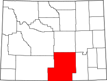 | |
| Towns | ||
| CDPs | ||
| Unincorporated communities | ||
| Ghost towns | ||