Dixon, Wyoming
| Dixon, Wyoming | |
|---|---|
| Town | |
|
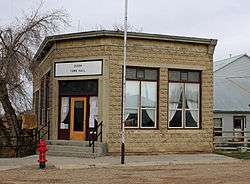
The Dixon Town Hall, located at B Street and North 3rd Street. | |
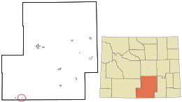 Location in Carbon County and the state of Wyoming. | |
 Dixon, Wyoming Location in the United States | |
| Coordinates: 41°2′6″N 107°32′10″W / 41.03500°N 107.53611°WCoordinates: 41°2′6″N 107°32′10″W / 41.03500°N 107.53611°W | |
| Country | United States |
| State | Wyoming |
| County | Carbon |
| Area[1] | |
| • Total | 0.13 sq mi (0.34 km2) |
| • Land | 0.13 sq mi (0.34 km2) |
| • Water | 0 sq mi (0 km2) |
| Elevation | 6,355 ft (1,937 m) |
| Population (2010)[2] | |
| • Total | 97 |
| • Estimate (2012[3]) | 96 |
| • Density | 746.2/sq mi (288.1/km2) |
| Time zone | Mountain (MST) (UTC-7) |
| • Summer (DST) | MDT (UTC-6) |
| ZIP code | 82323 |
| Area code(s) | 307 |
| FIPS code | 56-20690[4] |
| GNIS feature ID | 1587668[5] |
Dixon is a town in Carbon County, Wyoming, United States. The population was 97 at the 2010 census.
Geography
Dixon is located at 41°2′6″N 107°32′10″W / 41.03500°N 107.53611°W (41.034934, -107.536111).[6]
According to the United States Census Bureau, the town has a total area of 0.13 square miles (0.34 km2), all of it land.[1]
Demographics
| Historical population | |||
|---|---|---|---|
| Census | Pop. | %± | |
| 1920 | 170 | — | |
| 1930 | 145 | −14.7% | |
| 1940 | 94 | −35.2% | |
| 1950 | 124 | 31.9% | |
| 1960 | 108 | −12.9% | |
| 1970 | 72 | −33.3% | |
| 1980 | 82 | 13.9% | |
| 1990 | 70 | −14.6% | |
| 2000 | 79 | 12.9% | |
| 2010 | 97 | 22.8% | |
| Est. 2015 | 95 | [7] | −2.1% |
2010 census
As of the census[2] of 2010, there were 97 people, 43 households, and 27 families residing in the town. The population density was 746.2 inhabitants per square mile (288.1/km2). There were 64 housing units at an average density of 492.3 per square mile (190.1/km2). The racial makeup of the town was 88.7% White, 3.1% African American, 1.0% Native American, 4.1% from other races, and 3.1% from two or more races. Hispanic or Latino of any race were 12.4% of the population.
There were 43 households of which 30.2% had children under the age of 18 living with them, 46.5% were married couples living together, 2.3% had a female householder with no husband present, 14.0% had a male householder with no wife present, and 37.2% were non-families. 30.2% of all households were made up of individuals and 4.7% had someone living alone who was 65 years of age or older. The average household size was 2.26 and the average family size was 2.70.
The median age in the town was 33.5 years. 21.6% of residents were under the age of 18; 9.4% were between the ages of 18 and 24; 30.9% were from 25 to 44; 25.8% were from 45 to 64; and 12.4% were 65 years of age or older. The gender makeup of the town was 56.7% male and 43.3% female.
2000 census
As of the census[4] of 2000, there were 79 people, 41 households, and 23 families residing in the town. The population density was 584.1 people per square mile (217.9/km²). There were 67 housing units at an average density of 495.4 per square mile (184.8/km²). The racial makeup of the town was 96.20% White and 3.80% Native American. Hispanic or Latino of any race were 1.27% of the population.
There were 41 households out of which 19.5% had children under the age of 18 living with them, 51.2% were married couples living together, 2.4% had a female householder with no husband present, and 43.9% were non-families. 39.0% of all households were made up of individuals and 14.6% had someone living alone who was 65 years of age or older. The average household size was 1.93 and the average family size was 2.57.
In the town the population was spread out with 15.2% under the age of 18, 6.3% from 18 to 24, 29.1% from 25 to 44, 30.4% from 45 to 64, and 19.0% who were 65 years of age or older. The median age was 45 years. For every 100 females there were 102.6 males. For every 100 females age 18 and over, there were 139.3 males.
The median income for a household in the town was $23,750, and the median income for a family was $37,500. Males had a median income of $35,417 versus $16,250 for females. The per capita income for the town was $15,950. There were no families and 8.0% of the population living below the poverty line, including no under eighteens and none of those over 64.
Education
Public education in the town of Dixon is provided by Carbon County School District #1. Little Snake River Valley School, a K-12 campus, serves the town.
References
- 1 2 "US Gazetteer files 2010". United States Census Bureau. Retrieved 2012-12-14.
- 1 2 "American FactFinder". United States Census Bureau. Retrieved 2012-12-14.
- ↑ "Population Estimates". United States Census Bureau. Retrieved 2013-06-01.
- 1 2 "American FactFinder". United States Census Bureau. Retrieved 2008-01-31.
- ↑ "US Board on Geographic Names". United States Geological Survey. 2007-10-25. Retrieved 2008-01-31.
- ↑ "US Gazetteer files: 2010, 2000, and 1990". United States Census Bureau. 2011-02-12. Retrieved 2011-04-23.
- ↑ "Annual Estimates of the Resident Population for Incorporated Places: April 1, 2010 to July 1, 2015". Retrieved July 2, 2016.
- ↑ "Census of Population and Housing". Census.gov. Retrieved June 4, 2015.
Municipalities and communities of Carbon County, Wyoming, United States | ||
|---|---|---|
| Cities | 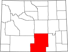 | |
| Towns | ||
| CDPs | ||
| Unincorporated communities | ||
| Ghost towns | ||