Encampment, Wyoming
| Encampment, Wyoming | |
|---|---|
| Town | |
 Location in Carbon County and the state of Wyoming. | |
 Encampment, Wyoming Location in the United States | |
| Coordinates: 41°12′30″N 106°47′28″W / 41.20833°N 106.79111°WCoordinates: 41°12′30″N 106°47′28″W / 41.20833°N 106.79111°W | |
| Country | United States |
| State | Wyoming |
| County | Carbon |
| Area[1] | |
| • Total | 1.60 sq mi (4.14 km2) |
| • Land | 1.60 sq mi (4.14 km2) |
| • Water | 0 sq mi (0 km2) |
| Elevation[2] | 7,277 ft (2,218 m) |
| Population (2010)[3] | |
| • Total | 450 |
| • Estimate (2012[4]) | 443 |
| • Density | 281.3/sq mi (108.6/km2) |
| Time zone | Mountain (MST) (UTC-7) |
| • Summer (DST) | MDT (UTC-6) |
| Area code(s) | 307 |
| FIPS code | 56-32650[5] |
Encampment is a town in Carbon County, Wyoming, United States. The population was 450 at the 2010 census.
History
Known also as " Grand Encampment", this town along the Colorado-Wyoming border was, at the turn of the twentieth century, a booming center of copper mining and smelting. At one point a sixteen-mile tramway was built to carry copper ore from the mountains into the town for smelting. This steam powered tramway was, at the time, the longest in the world.[6] A sharp drop in copper prices and disastrous fires drove the mining company into bankruptcy.[7] Mining operations ceased in the early twentieth century. A large sawmill operated in the town between 1950 and 1998.[8]
Geography
Encampment is located at 41°12′30″N 106°47′28″W / 41.20833°N 106.79111°W (41.208216, -106.791215).[9]
According to the United States Census Bureau, the town has a total area of 1.60 square miles (4.14 km2), all of it land.[1]
Demographics
| Historical population | |||
|---|---|---|---|
| Census | Pop. | %± | |
| 1910 | 421 | — | |
| 1920 | 230 | −45.4% | |
| 1930 | 209 | −9.1% | |
| 1940 | 331 | 58.4% | |
| 1950 | 288 | −13.0% | |
| 1960 | 333 | 15.6% | |
| 1970 | 321 | −3.6% | |
| 1980 | 611 | 90.3% | |
| 1990 | 490 | −19.8% | |
| 2000 | 443 | −9.6% | |
| 2010 | 450 | 1.6% | |
| Est. 2015 | 438 | [10] | −2.7% |
2010 census
As of the census[3] of 2010, there were 450 people, 227 households, and 128 families residing in the town. The population density was 281.3 inhabitants per square mile (108.6/km2). There were 371 housing units at an average density of 231.9 per square mile (89.5/km2). The racial makeup of the town was 97.1% White, 0.7% Native American, 0.7% from other races, and 1.6% from two or more races. Hispanic or Latino of any race were 1.6% of the population.
There were 227 households of which 18.1% had children under the age of 18 living with them, 48.0% were married couples living together, 4.4% had a female householder with no husband present, 4.0% had a male householder with no wife present, and 43.6% were non-families. 39.2% of all households were made up of individuals and 14.5% had someone living alone who was 65 years of age or older. The average household size was 1.98 and the average family size was 2.63.
The median age in the town was 51.6 years. 17.6% of residents were under the age of 18; 3.3% were between the ages of 18 and 24; 17.1% were from 25 to 44; 38.1% were from 45 to 64; and 23.6% were 65 years of age or older. The gender makeup of the town was 53.1% male and 46.9% female.
2000 census
As of the census[5] of 2000, there were 443 people, 209 households, and 137 families residing in the town. The population density was 277.1 people per square mile (106.9/km²). There were 336 housing units at an average density of 210.2 per square mile (81.1/km²). The racial makeup of the town was 97.52% White, 0.45% Native American, 0.68% Asian, and 1.35% from two or more races. Hispanic or Latino of any race were 0.68% of the population.
There were 209 households out of which 23.0% had children under the age of 18 living with them, 56.9% were married couples living together, 2.9% had a female householder with no husband present, and 34.4% were non-families. 32.1% of all households were made up of individuals and 12.9% had someone living alone who was 65 years of age or older. The average household size was 2.12 and the average family size was 2.64.
In the town the population was spread out with 19.0% under the age of 18, 5.2% from 18 to 24, 23.5% from 25 to 44, 36.3% from 45 to 64, and 16.0% who were 65 years of age or older. The median age was 47 years. For every 100 females there were 115.0 males. For every 100 females age 18 and over, there were 116.3 males.
The median income for a household in the town was $29,444, and the median income for a family was $37,083. Males had a median income of $36,786 versus $19,375 for females. The per capita income for the town was $20,632. About 9.1% of families and 12.8% of the population were below the poverty line, including 19.6% of those under age 18 and 12.0% of those age 65 or over.
Education
Public education in the town of Encampment is provided by Carbon County School District #2. Encampment School , a K-12 campus, serves the town.
References
- 1 2 "US Gazetteer files 2010". United States Census Bureau. Retrieved 2012-12-14.
- ↑ "GNIS detail- encampment". United States Geological Survey. Retrieved 2013-06-05.
- 1 2 "American FactFinder". United States Census Bureau. Retrieved 2012-12-14.
- ↑ "Population Estimates". United States Census Bureau. Retrieved 2013-06-01.
- 1 2 "American FactFinder". United States Census Bureau. Retrieved 2008-01-31.
- ↑ C. S. Petersen (1915). Men of Wyoming: the national newspaper reference book of Wyoming containgin photographs and biographies of over three hundred men residents. AbeBooks; a reprint of a 1915 publication by Princeton University. p. 77.
- ↑ "Encampment River Valley, Wyoming Assessment Report" (PDF). Wyoming Rural Development Council. Retrieved 2010-10-21.
- ↑ "A Strategic Economic Development Plan for The Town of Saratoga, Wyoming" (PDF). NorthStar Economics, Inc. Retrieved 2010-10-20.
- ↑ "US Gazetteer files: 2010, 2000, and 1990". United States Census Bureau. 2011-02-12. Retrieved 2011-04-23.
- ↑ "Annual Estimates of the Resident Population for Incorporated Places: April 1, 2010 to July 1, 2015". Retrieved July 2, 2016.
- ↑ "Census of Population and Housing". Census.gov. Retrieved June 4, 2015.
Municipalities and communities of Carbon County, Wyoming, United States | ||
|---|---|---|
| Cities | 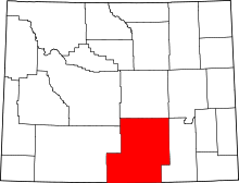 | |
| Towns | ||
| CDPs | ||
| Unincorporated communities | ||
| Ghost towns | ||