U.S. Route 30 in Iowa
| |||||||
|---|---|---|---|---|---|---|---|
|
A map of Iowa's Interstates (blue) and US Highways (orange) with US 30 highlighted in red. | |||||||
| Route information | |||||||
| Maintained by Iowa DOT | |||||||
| Length: | 330.266 mi[1] (531.512 km) | ||||||
| Existed: | 1926[2] – present | ||||||
| History: | Lincoln Highway from 1913–1928[2] | ||||||
| Major junctions | |||||||
| West end: |
| ||||||
| East end: |
| ||||||
| Location | |||||||
| Counties: | |||||||
| Highway system | |||||||
| |||||||

_map.svg.png)
U.S. Highway 30 (US 30) is a major east–west U.S. Highway which spans 330 miles (530 km) across the state of Iowa. It is the longest primary highway in the state and is maintained by the Iowa Department of Transportation (Iowa DOT). The route in Iowa begins at the Missouri River crossing at Blair, Nebraska, and ends at the Mississippi River crossing at Clinton. Along the way, it serves Denison and Carroll in western Iowa, Boone, Ames, and Marshalltown in central Iowa, and Tama, Cedar Rapids, and DeWitt in eastern Iowa. Cutting across the central portion of the state, US 30 runs within close proximity of the Union Pacific Railroad's Overland Route for its entire length.
US 30 was originally conceived as a part of the Lincoln Highway, the first transcontinental highway in the United States. A route through Iowa was chosen because of the important link between Omaha, Nebraska, and Chicago, Illinois. As the U.S. Highway System came into being in the 1920s, and the Lincoln Highway became US 30, federal money started to pay for paving Iowa's dirt roads. By 1931, it had been paved across the entire state.
The route of the Lincoln Highway and US 30 has accommodated the changing needs of the traveling public. Early Lincoln Highway travelers were directed into many small towns as the route traveled 358 miles (576 km) across the state. Towards the middle of the 20th century, the route was straightened, bypassing most downtown areas and several towns altogether. More recently, long sections of US 30 have been upgraded to a four-lane expressway to meet the needs of increasing traffic. Since 2006, the highway has been designated an Iowa Heritage Byway by Iowa DOT, the first highway in the state with that distinction.
Route description
US 30 extends from west to east across the central portion of Iowa, with much of the highway traveling through rolling farmland. Small towns dot the entire route, which connects the larger cities of Denison, Ames, Cedar Rapids, and Clinton. Between Ogden and Mount Vernon, significant portions of the highway have been upgraded to a four-lane freeway.[3]
Western Iowa
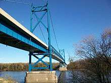
US 30 enters the western end of Iowa by crossing the Missouri River on the Blair Bridge, located east of the Nebraska town of the same name. Adjacent to the highway bridge is the Union Pacific Railroad's river crossing for the Overland Route. The highway runs roughly parallel to the rail line for its entire run across Iowa.[4][5] For nine miles (14 km), traffic moves through the flat Missouri River bottoms, passing DeSoto National Wildlife Refuge on the way to Missouri Valley.[1] At Missouri Valley, it intersects Interstate 29 (I-29) at a partial cloverleaf interchange. It enters the Boyer River valley through the Loess Hills, a region of wind-deposited silt extending from north of Sioux City to extreme northwestern Missouri.[6] The rolling Loess Hills rise 50–100 feet (15–30 m) above the roadway while the land in the valley stays relatively flat.[7] US 30 enters Logan and intersects the eastern end of Iowa Highway 127 (Iowa 127). The highway runs parallel to the Boyer River as well as the Overland Route in a general northeast direction from Logan.[3] Four miles (6.4 km) east of Logan is the western end of Iowa 44, which extends 105 miles (169 km) east to Des Moines.[1]
The highway enters Crawford County north of Dunlap in Harrison County. For seventeen miles (27 km), US 30 passes through farmland and the small communities of Dow City and Arion. For one-half mile (800 m) through Denison, it overlaps US 59 and Iowa 141, which run concurrently through the town.[1] The Iowa DOT refers to routes which overlap other routes as duplicate routes.[1] It follows the East Boyer River through Denison as the Boyer River forks west of the northern intersection with US 59 / Iowa 141. US 30 travels north-northeasterly towards Vail. Between Vail and Westside, the highway ceases following the East Boyer River and heads due east towards Arcadia and Carroll in Carroll County.[3]
At Carroll it intersects US 71 on the western side of the city. Continuing east, the highway goes through the town of Glidden and passes to the north of Ralston, west of the Greene County line. North of Scranton it meets the northern end of Iowa 25. Between Scranton and Jefferson, US 30 crosses the Raccoon River.[3] US 30 crosses Iowa 4 and Iowa 144 on the northern edge of Jefferson and Grand Junction, the latter of the cities named for its location at the junction of the historic Chicago & Northwestern and Chicago, Rock Island and Pacific Railroads,[8] now both owned by Union Pacific, respectively. East of Grand Junction, the highway passes over the Overland Route where it stays south of the railroad until Le Grand.[5]
Central Iowa
Four miles (6.4 km) west of Ogden, US 30 is joined by US 169 from the north. The two highways run concurrently until reaching Ogden, where the road becomes a four-lane expressway. US 169 exits to the south at a partial cloverleaf interchange, while US 30 continues east through Boone County and descends into the Des Moines River valley.[3] It ascends from the valley and travels another two miles (3.2 km) to a four-way stop in Boone, which is the last stop along the route until Iowa 1 in Mt. Vernon. Three miles (4.8 km) east of Boone, it meets Iowa 17 at a diamond interchange. One mile (1.6 km) east of that interchange is a shortcut to northbound Iowa 17.[1]
Traffic is filtered into Ames and Iowa State University (ISU) from US 30 through five interchanges. On the outskirts of Ames are the Lincoln Way interchanges, access to and from Lincoln Way is handled by two half interchanges three-quarters mile (1.2 km) apart. From the interchanges to the Story County line one and three-quarters miles (2.8 km) away, Lincoln Way is designated as Iowa 930, but is never signed as such.[1] The South Dakota Avenue interchange primarily serves the southwestern part of Ames. The University Boulevard (formerly Elwood Drive) exit provides access to the Iowa State University campus and Iowa State Center, ISU's cultural and athletics complex.[9] The Duff Avenue interchange provides access to Ames's east side. US 69 and Interstate 35 Business Loop are designated along Duff Avenue. From Duff to I-35, US 30 is overlapped by the I-35 Business Loop. Between the Duff and Dayton Avenue interchanges, it crosses the South Skunk River.[3] The Dayton Avenue interchange serves hotels and restaurants and is a travel stop for I-35 travelers.[10]
East of the Dayton Avenue interchange is I-35, which connects US 30 to Minneapolis, Minnesota, to the north, and Des Moines to the south. Continuing east, the expressway travels six and a half miles (10.5 km) to Nevada, six miles (9.7 km) more to the US 65 interchange at Colo, and seven and a half miles (12.1 km) to where the four-lane expressway ends at State Center. Just before the Iowa 330 interchange seven and a half miles (12.1 km) later, the road becomes a four-lane expressway again. One mile (1.6 km) to the east are two half-interchanges with U.S. Highway 30 Business (US 30 Business).[1]
US 30 bypasses Marshalltown approximately one-quarter mile (400 m) south of its business loop. Near Marshalltown Community College, it intersects Iowa 14 at a diamond interchange. The 18th Avenue interchange on the southeastern side of Marhsalltown is the eastern end of the business loop. From Marshalltown, it travels five miles (8.0 km) to Le Grand, crossing over the Overland Route rail corridor on the west side.[5] It bypasses Le Grand to the north, where it intersects the northern end of Iowa 146 at a diamond interchange. Continuing east, the highway enters Tama County. It rises over a large hill north of Montour and then descends into the Iowa River valley.[3]
East of the Iowa River is the Meskwaki Settlement, which is home to about 800 Meskwaki Indians and the Meskwaki Casino and Resort.[1] As it heads into the Tama–Toledo area, the expressway bisects the two communities. Between the two cities, it meets US 63 at a partial cloverleaf interchange.[11] From US 63 it turns to the southeast to skirt Tama's east side. It rejoins the former alignment of the highway east of Tama and heads due east, along section lines in Tama and Benton Counties, and does not enter another town for 40 miles (64 km).[1]
Eastern Iowa
US 30 enters Benton County nine miles (14 km) north of Belle Plaine at an intersection with Iowa 21. It continues east along a section line, passing the communities of Keystone, Van Horne, and Blairstown. Three and a half miles (5.6 km) southwest of Newhall, or four and a quarter miles (6.8 km) southeast of Van Horne, it meets US 218 and becomes a four-lane road. US 30 and US 218 travel together due east towards Cedar Rapids, passing Norway and Atkins.[1]
On the west end of Cedar Rapids, US 30 / US 218 turn to the southeast at the 16th Avenue SW interchange. Two miles (3.2 km) to the southeast is the Williams Boulevard interchange, where US 151 joins US 30 and US 218. For four miles (6.4 km), US 30 / US 151 / US 218 is a wrong-way concurrency; that is, where two or more routes heading in opposite directions share the same highway. In this instance, US 30 is the main east–west road while US 151 and US 218 are duplicate routes, nominally heading north and south, respectively. At the I-380 interchange, US 218 leaves US 30 / US 151 and joins the Avenue of the Saints highway. East of I-380, US 30 / US 151 serve as a divider between the Lincolnway Village neighborhood to the south and a light industrial district to the north.[1]
South of Bertram, the two routes cross the Cedar River before US 151 splits away from US 30 to the north at a trumpet interchange.[3] This interchange is the southern end of Iowa 13. It continues east towards Mount Vernon, two miles (3.2 km) west of which, the four-lane highway becomes a two-lane road. In Mount Vernon, it intersects Iowa 1 at a roundabout. One mile (1.6 km) from Iowa 1, it enters Lisbon.[1]
Over the next 45 miles (72 km), US 30 passes through a small town every four to seven miles (6 to 11 km). In Cedar County it passes through Mechanicsville, Stanwood, Clarence and Lowden. In Stanwood, it is overlapped by Iowa 38 for one mile (1.6 km). In Clinton County, it passes through Wheatland, Calamus, and Grand Mound before reaching a full cloverleaf interchange with US 61 at DeWitt. US 30 overlaps US 61 for one mile (1.6 km), crossing the Union Pacific Overland Route in the process, and leaves US 61 via a trumpet interchange.[1]
US 30 continues east as an expressway, passing DeWitt to the south. Five miles (8 km) east of DeWitt, it crosses back over to the north side of the Overland Route.[1] West of the Clinton city limits is an interchange with Clinton County Road Z36 (CR Z36), which serves Low Moor and as a shortcut to southbound US 67. East of CR Z36, it passes the Clinton Municipal Airport and a large chemical plant.[3] As it approaches Mill Creek Parkway, it descends over 100 feet (30 m) in elevation into the flat Mississippi River valley, where it meets US 67.[12]
US 30 / US 67 head east along Lincoln Way and ascend 50 feet (15 m) onto a plateau, atop which reside stores and restaurants.[12] As they continue east, the two routes split into one-way streets, eastbound Liberty Avenue and westbound Camanche Avenue. The one-way street alignment ends at 11th Avenue South, but quickly begins again as US 30 / US 67 turn to the north onto northbound South Third Street and southbound South Fourth Street. At Eighth Avenue South, US 30 splits away from US 67 and onto the Gateway Bridge and crosses into Illinois.[13]
History
The path which US 30 follows has changed since it was originally planned as the Lincoln Highway in the early 1910s. The first path connected as many downtown areas as possible, in order to create awareness about the Good Roads Movement and the Lincoln Highway.[14] As the primary highway system of Iowa matured, and the Lincoln Highway yielded to US 30, the highway was gradually straightened, leaving many towns off the route.[15] More recently, new construction has routed traffic away from the straighter roads and onto sections of freeway and expressway.[3]
Lincoln Highway
| |
|---|---|
| Location: | Council Bluffs–Clinton |
| Length: | 358 mi[16] (576 km) |
| Existed: | 1913–1928 |
US 30 was created with the U.S. Highway System in 1926, but the route it takes dates back to 1913, when the Lincoln Highway Association (LHA) designated the route across the country. The brainchild of Carl Fisher, the Lincoln Highway was the first highway to cross the United States, connecting New York City to San Francisco. In Iowa, it was uncertain exactly where the Lincoln Highway would run. As of August 1913, no definite route had been planned; the only certainty was the route would pass through Iowa. Iowans raised over $5 million (equivalent to $120 million in 2016 dollars[17]) for the construction of the road.[18] On September 14, 1913, the Lincoln Highway Association announced the route. It was 358 miles (576 km) of dirt roads, connecting Clinton, DeWitt, Cedar Rapids, Tama, Marshalltown, Ames, Jefferson, Denison, Logan, and Council Bluffs.[16] The route was marked by a red, white, and blue tricolor emblazoned with an L. The route markers were painted upon telephone poles, bridges, and nearby buildings to show travelers the way.[19]
While not ideal for transcontinental travel, Iowa's dirt roads were of high quality. Foreigners even compared them to the best roads in France. However, the same could not be said when they were wet. The mud was so thick and viscous it was nicknamed "gumbo".[14] To show travelers the obvious benefits of paved roads, the Lincoln Highway Association began the process of creating seedling miles of paved roads. The idea, according to Henry B. Joy, then-president of the Lincoln Highway Association, was to show travelers, for one mile (1.6 km), how fast and smooth their trip could be, only to bring them back to reality at the end of the mile. Seedling miles were placed at least six miles (9.7 km) from the nearest town and in areas where the terrain was rough. Between August 1918 and June 1919, Iowa's first seedling mile was built in Linn County, west of Mount Vernon. The ribbon of concrete, which was 16 feet (4.9 m) wide, 7 1⁄2 inches (19 cm) thick, and crowned for drainage 1 1⁄2 inches (3.8 cm), cost nearly $35,000 (equivalent to $479,000 in 2016 dollars[17]) to build.[14]
Despite the success of the seedling miles across the country, Iowa lagged behind other states in improving its roads. Before 1924, Iowa's 99 counties, not the state highway commission, were responsible for the construction and maintenance of the state's roads.[20] In the 1920s, road paving cost $30,000 per mile ($19,000/km), equivalent to $719,000 per mile ($447,000/km) in 2016 dollars;[17] a major obstacle for county boards of supervisors that wanted to pave its roads.[16] When counties could afford to build roads, the Iowa State Highway Commission required extensive grading to be done before paving. In 1922, only five percent of Iowa's roads, 334 miles (538 km), were paved. By 1924, twenty percent of the Lincoln Highway in Iowa had been paved, and by 1931, it was paved continuously from New York City to Missouri Valley, Iowa.[14]
1930s–1950s

.svg.png)
.svg.png)
When the Lincoln Highway became U.S. Highway 30 in 1926, the route was 358 miles (576 km) long and passed through every town along the way.[16] Starting in the 1930s, the route's alignment began to be straightened. By the mid-1930s, it was routed west of Missouri Valley on old Iowa 130. The US 30 alignment south of Missouri Valley became U.S. Highway 30 Alternate.[21] By 1952, it had moved south of Marshalltown and was replaced by Iowa 330 and a seventeen-mile (27 km) southern jaunt through Belle Plaine had been replaced by a straight road.[15] In 1955, a couple of routing changes occurred. In Cedar Rapids, it began its move to the south, avoiding the downtown area, and in Clinton, it was rerouted over the Gateway Bridge, allowing Iowa 136 to cross the Lyons-Fulton Bridge.[22][23] However, by 1957, the old alignment through Clinton and across the Lyons-Fulton Bridge was numbered U.S. Highway 30 Alternate.[23][24]
1960s–1980s
In the 1960–1970s, Iowa DOT started to build freeway segments along US 30. In 1965, it was straightened and rerouted to the south of Ogden and Boone along an eleven-mile (18 km), four-lane stretch of road.[25][26] By the end of the 1960s, both of the alternate routes had been turned over to local jurisdictions. The western route became Iowa 183, and the eastern route reverted to Iowa 136. By 1973, that new stretch of road had been extended fourteen miles (23 km) along a four-lane bypass around Ames. The old alignment became Iowa 930.[27][28] In eastern Iowa, a new, twenty-mile-long (32 km) freeway connected DeWitt and Clinton by 1976.[29][30] By 1985, the bypass of Cedar Rapids had been completed from 16th Avenue SW to Iowa 13 near Bertram. The bypass was extended five miles (8 km) further west in 1989.[31][32] Between 1996 and 2000, an $8.2-million extension (equivalent to $12.4 million in 2016 dollars[17]) was built to connect the bypass to the western intersection of US 218.[33][34][35]
Since the Cedar Rapids bypass was completed in 1985, on occasion, traffic has had to be rerouted off of US 30. The bypass's proximity to the Union Pacific Railroad mainline resulted in an elevated roadway between Edgewood Road and Sixth Street SW. When strong winds come from the south, fog produced by an Archer Daniels Midland plant adjacent to the highway billows over the road making driving dangerous.[36] The Iowa DOT set up an emergency detour from Edgewood Road SW north to 16th Avenue SW east to 6th Street SW back to US 30. The frequency of fog-related detours has decreased in recent years due to improved technology and the plant's expansion and relocation of cooling towers away from the highway.[36]
1990s to the present
The 1990s saw more construction of four-lane roads along US 30. Stretches of four-lane roads that had already been constructed were extended towards other communities. In Story County, it was widened to four lanes from the I-35 interchange to US 65 at Colo. The original 1950s-era bypass of Marshalltown was itself bypassed in 1997 by a freeway three-quarters mile (1.2 km) south of the original bypass.[1] That road, Iowa Avenue in Marshalltown, was designated as U.S. Highway 30 Business, the first business route along US 30 in Iowa. The four-lane stretch southeast of Cedar Rapids was extended another five miles (8.0 km) to a point two miles (3.2 km) west of Mount Vernon, costing $5.6 million (equivalent to $8.46 million in 2016 dollars[17]) to build.[33][37]
Since the beginning of the 21st century, Iowa DOT has continued to widen US 30 to four lanes. In 2004, an $18.6-million (equivalent to $28.1 million in 2016 dollars[17]), four-lane section opened from east of Marshalltown to the Meskwaki Settlement west of Tama, bypassing Le Grand.[33] In 2010, two sections of expressway were completed. A seven-and-a-half-mile-long (12 km) section from Colo to State Center opened to westbound travelers on November 29, while the eastbound lanes opened a week later.[38][39] The seven-and-a-half-mile-long (12 km) section, which bypasses the Tama/Toledo area, opened in two segments. The first of which opened on November 1, and the second on November 25.[40] On July 7, 2011, a section from State Center to Iowa 330 opened in Marshall County.[41] This created a four-lane expressway from Ogden to Tama, covering 75 miles (121 km).[1]
Legacy of the Lincoln Highway
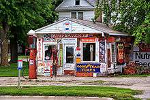
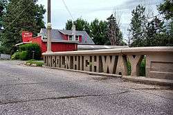
While the Lincoln Highway has not been an official route for 90 years, it is still a source of pride in the communities and regions through which it passed. Nearly 85 percent of the original Lincoln Highway is still drivable, although much is gravel.[42] Most of what is drivable is either along US 30 or within one mile (1.6 km).[3] The Lincoln Highway bridge in Tama was built in 1915. It was restored in the 1980s after local officials feared losing the then-deteriorating bridge.[43] Preston's Service Station, a landmark of Belle Plaine, has become a Lincoln Highway museum.[44] Monuments were built along the route to honor not only Abraham Lincoln,[45] but to honor Iowans who were influential for planning its route.[46]
In 1992, the Lincoln Highway Association was reformed with a chapter in each state through which the highway passed. The new LHA is a historical preservation group that wants to preserve the remaining sections of the highway.[47] The Iowa chapter of the LHA has, since 2008, sponsored a tour of the Lincoln Highway. To keep friendly to classic cars, the tour does not travel upon the sections of the road which are gravel.[48] After years of lobbying by the LHA, the Iowa Department of Transportation, in 2006, designated the Lincoln Highway the first Iowa Heritage Byway.[49] The 2010 Transportation Map of Iowa showed the path designated as the Iowa Heritage Byway for the first time.[3]
Major intersections
| County | Location | mi[1] | km | Exit[3] | Destinations | Notes |
|---|---|---|---|---|---|---|
| Washington | Blair | Continuation into Nebraska | ||||
| Missouri River | 0.000 | 0.000 | Nebraska–Iowa state line (Blair Bridge) | |||
| Harrison | Missouri Valley | 9.243 | 14.875 | I-29 exit 75 | ||
| Logan | 19.279 | 31.027 | ||||
| Jefferson Township | 23.166 | 37.282 | ||||
| Dunlap | 37.750 | 60.753 | West end of Iowa 37 overlap | |||
| 37.985 | 61.131 | East end of Iowa 37 overlap | ||||
| Crawford | Denison | 54.091 | 87.051 | West end of US 59 / Iowa 141 overlap | ||
| 54.722 | 88.067 | East end of US 59 / Iowa 141 overlap | ||||
| Carroll | Carroll | 81.478 | 131.126 | |||
| Greene | Kendrick–Scranton township line | 99.359 | 159.903 | |||
| Jefferson | 108.302 | 174.295 | ||||
| Grand Junction | 115.364 | 185.660 | ||||
| Boone | Amaqua–Beaver township line | 122.373 | 196.940 | West end of US 169 overlap | ||
| Ogden | 125.471 | 201.926 | 126 | East end of US 169 overlap | ||
| Des Moines–Worth township line | 137.430 | 221.172 | 137 | |||
| Colfax Township | 142.361– 143.062 | 229.108– 230.236 | 142 | Lincoln Way (Iowa 930) – Napier | ||
| Story | Ames | 144.998 | 233.352 | 144 | South Dakota Avenue – Kelley | |
| 147.117 | 236.762 | 146 | University Boulevard – Iowa State University | |||
| 148.635 | 239.205 | 148 | West end of I-35 Business overlap, access to Mary Greeley Medical Center | |||
| 149.858 | 241.173 | 150 | Dayton Avenue | |||
| 150.646 | 242.441 | 151 | I-35 exit 111; exits signed as 151A (south) and 151B (north); east end of I-35 Business overlap | |||
| Nevada | 157.708 | 253.806 | 157 | 19th Street – Nevada | ||
| Colo | 164.168 | 264.203 | 164 | |||
| Marshall | Washington Township | 179.047 | 288.148 | 179 | ||
| Timber Creek Township | 181.229 | 291.660 | 181 | Eastbound exit and westbound entrance only | ||
| 182.139 | 293.124 | 182 | Oaks Avenue, Highland Acres Road | Westbound exit and eastbound entrance only | ||
| Marshalltown | 184.648 | 297.162 | 185 | Access to Marshalltown Medical and Surgical Center | ||
| 186.130 | 299.547 | 186 | US 30 Business signed westbound only | |||
| Le Grand | 191.302 | 307.871 | 192 | |||
| Tama | Toledo Township | 200.330 | 322.400 | — | Westbound exit and eastbound entrance only | |
| Toledo | 202.162 | 325.348 | 202 | |||
| Tama Township | 204.661 | 329.370 | 204 | US 30 Business only signed eastbound | ||
| Tama–Benton county line | York–Kane township line | 217.222 | 349.585 | |||
| Benton | Fremont Township | 231.126 | 371.961 | West end of US 218 overlap | ||
| Linn | Clinton Township | 243.748– 244.269 | 392.274– 393.113 | 246 | 16th Avenue SW, 80th Street SW – Fairfax | Future Iowa 100 interchange[50] |
| Cedar Rapids | 246.248 | 396.298 | 248 | West end of US 151 overlap | ||
| 247.619 | 398.504 | 250 | Edgewood Road SW | |||
| 249.802 | 402.017 | 252A | 6th Street SW – Hawkeye Downs | |||
| 250.135 | 402.553 | 252B–C | I-380 exit 16; east end of US 218 overlap | |||
| 250.812 | 403.643 | 253 | Kirkwood Boulevard SW, Bowling Street SW | |||
| 251.809 | 405.247 | 254 | ||||
| Bertram Township | 256.730 | 413.167 | 259 | East end of US 151 overlap | ||
| Mount Vernon | 262.982 | 423.229 | ||||
| Cedar | Stanwood | 277.365 | 446.376 | West end of Iowa 38 overlap | ||
| Fremont–Dayton township line | 278.381 | 448.011 | East end of Iowa 38 overlap | |||
| Clinton | DeWitt | 308.548 | 496.560 | 311 | West end of US 61 overlap, access to DeWitt Community Hospital | |
| 309.716 | 498.440 | 312 | East end of US 61 overlap | |||
| 311.158 | 500.760 | 313 | 6th Avenue – DeWitt | |||
| Eden–Camanche township line | 320.758 | 516.210 | 323 | |||
| Clinton | 326.562 | 525.551 | West end of US 67 overlap; US 67 is the Great River Road | |||
| 329.868 | 530.871 | East end of US 67 overlap | ||||
| Mississippi River | 330.266 | 531.512 | Iowa–Illinois state line (Gateway Bridge) | |||
| Whiteside | Garden Plain Township | Continuation into Illinois | ||||
1.000 mi = 1.609 km; 1.000 km = 0.621 mi
| ||||||
See also
 Iowa portal
 U.S. Roads portal
- Bannered routes of U.S. Route 30
References
- 1 2 3 4 5 6 7 8 9 10 11 12 13 14 15 16 17 18 "2011 Volume of Traffic on the Primary Road System of Iowa" (PDF). Iowa Department of Transportation. January 1, 2011. Retrieved May 19, 2012.
- 1 2 Weingroff, Richard F. (March 30, 2009). "The Lincoln Highway". Highway History. Federal Highway Administration. Retrieved March 1, 2010.
- 1 2 3 4 5 6 7 8 9 10 11 12 13 Iowa State Highway Map (PDF) (Map). Iowa Department of Transportation. 2016. § A-N4. Retrieved April 13, 2010.
- ↑ Union Pacific Railroad. "UPRR Common Line Names" (PDF). Retrieved September 22, 2010.
- 1 2 3 Iowa Department of Transportation (July 1, 2008). "Iowa State Railroad Map" (PDF). Retrieved March 1, 2010.
- ↑ "Geology of the Loess Hills, Iowa". United States Geological Survey. July 1999. Retrieved July 10, 2010.
- ↑ Iowa State University (2005). "Iowa Geographic Map Server". Harrison County. Retrieved September 23, 2010.
- ↑ General Atlas of the World (Map). Rand, McNally & Co. 1898. p. 47. § F4.
- ↑ Iowa State University (September 2007). "Sesquicentennial: Iowa State University". Retrieved January 31, 2011.
- ↑ Ames Convention & Visitors Bureau (2008). 2008 Ames Area Visitors Guide. pp. 4–5.
- ↑ Speer, John (October 27, 2010). "Portion of U.S. 30 Expressway slated to open Monday". Tama News-Herald/Toledo Chronicle. Retrieved January 16, 2011.
- 1 2 Iowa State University. "Iowa Geographic Map Server". Retrieved July 4, 2010.
- ↑ Clinton inset (PDF) (Map). Iowa Department of Transportation. 2010. Retrieved July 11, 2010.
- 1 2 3 4 Rogers, Leah D.; Kernek, Clare L. (2004). Lincoln Higwhay Associations "Object Lesson": The Seedling Mile in Linn County, Iowa (PDF). pp. 2–3, 9.
- 1 2 Iowa State Highway Map (PDF) (Map). Iowa State Highway Commission. 1952. § I18-J19. Retrieved April 10, 2010.
- 1 2 3 4 Thompson, William H. (1989). Transportation in Iowa: A Historical Summary. Iowa Department of Transportation. pp. 100–101. ISBN 0-9623167-0-9.
- 1 2 3 4 5 6 Federal Reserve Bank of Minneapolis Community Development Project. "Consumer Price Index (estimate) 1800–". Federal Reserve Bank of Minneapolis. Retrieved October 21, 2016.
- ↑ "Says Iowa Will Get Lincoln Highway". Des Moines Tribune. September 3, 1913. p. 3.
- ↑ Gladding, Effie Price (1915). "Chapter VII". Across the Continent by the Lincoln Highway. New York: Brentano's. p. 111. Retrieved March 1, 2010.
- ↑ "Rules of the Road:Highway Safety". Iowa Pathways. Iowa Public Television. 2009. Retrieved March 1, 2010.
- ↑ Iowa State University (2005). "Iowa Geographic Map Server". Pottawattamie County. Retrieved April 10, 2010.
- ↑ Iowa State Highway Map (PDF) (Map). Iowa State Highway Commission. 1955. Clinton inset. Retrieved December 20, 2010.
- 1 2 Iowa State Highway Map (PDF) (Map). Iowa State Highway Commission. 1956. Clinton inset. Retrieved April 10, 2010.
- ↑ Iowa State Highway Map (PDF) (Map). Iowa State Highway Commission. 1957. Clinton inset. Retrieved April 10, 2010.
- ↑ Iowa State Highway Map (PDF) (Map). Iowa State Highway Commission. 1964. § I11-12. Retrieved December 20, 2010.
- ↑ Iowa State Highway Map (PDF) (Map). Iowa State Highway Commission. 1965. § I11-12. Retrieved April 24, 2010.
- ↑ Iowa State Highway Map (PDF) (Map). Iowa State Highway Commission. 1972. § I12-13. Retrieved December 20, 2010.
- ↑ Iowa State Highway Map (PDF) (Map). Iowa State Highway Commission. 1973. § I12-13. Retrieved April 10, 2010.
- ↑ Iowa State Highway Map (PDF) (Map). Iowa Department of Transportation. 1975. § K4. Retrieved December 20, 2010.
- ↑ Iowa State Highway Map (PDF) (Map). Iowa Department of Transportation. 1976. § K4. Retrieved April 10, 2010.
- ↑ Iowa State Highway Map (PDF) (Map). Iowa Department of Transportation. 1988. § I4. Retrieved December 20, 2010.
- ↑ Iowa State Highway Map (Map). Iowa Department of Transportation. 1989. § I4.
- 1 2 3 "Completing 6 Highway Corridors a Priority for State". The Gazette. Cedar Rapids – Iowa City. November 24, 1996. p. B4.
- ↑ Iowa State Highway Map (PDF) (Map). Iowa Department of Transportation. 1999. § H4. Retrieved December 20, 2010.
- ↑ Iowa State Highway Map (PDF) (Map). Iowa Department of Transportation. 2000. § H4. Retrieved April 24, 2010.
- 1 2 Hogan, Dick (December 31, 2001). "Highway 30 Sign Still Not Repaired". The Gazette. Cedar Rapids – Iowa City. p. 5.
- ↑ Iowa State Highway Map (PDF) (Map). Iowa Department of Transportation. 1997. § I4. Retrieved April 24, 2010.
- ↑ Iowa Department of Transportation (November 29, 2010). "New westbound U.S. 30 traffic lanes between Colo and State Center open today". Retrieved January 16, 2011.
- ↑ Iowa Department of Transportation (December 7, 2010). "Eastbound U.S. 30 lanes between Colo and State Center now open". Retrieved January 16, 2011.
- ↑ Iowa Department of Transportation (October 28, 2010). "Traffic pattern changes on U.S. 30 near Tama/Toledo set for Nov. 1". Retrieved January 16, 2011.
- ↑ McDonald, Doug (July 6, 2011). "Westbound lanes of U.S. 30 near State Center to open tomorrow". Iowa Department of Transportation. Retrieved August 22, 2012.
- ↑ Iowa Department of Transportation. "Historic Auto Trails: Lincoln Highway". Retrieved April 24, 2010.
- ↑ Iowa Lincoln Highway Association. "Tama County". Retrieved April 25, 2010.
- ↑ Iowa Lincoln Highway Association. "Benton County". Retrieved April 28, 2010.
- ↑ Iowa Lincoln Highway Association. "Greene County". Retrieved April 28, 2010.
- ↑ Iowa Lincoln Highway Association. "Clinton County". Retrieved April 28, 2010.
- ↑ Lincoln Highway Association. "Contact Us". Retrieved April 28, 2010.
- ↑ Iowa Lincoln Highway Association (March 17, 2010). "ILHA Motor Tour". Retrieved April 28, 2010.
- ↑ Iowa Lincoln Highway Association (Spring 2009). "Along the Lincoln Highway" (PDF). Retrieved April 28, 2010.
- ↑ Schmidt, Mitchell (November 23, 2016). "Highway 100 extension opening delayed till December". The Gazette. Cedar Rapids, Iowa. Retrieved November 29, 2016.
| Previous state: Nebraska |
Iowa | Next state: Illinois |