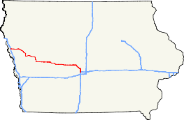
Iowa Highway 141
| ||||
|---|---|---|---|---|
 | ||||
| Route information | ||||
| Maintained by Iowa DOT | ||||
| Length: | 155.362 mi[1] (250.031 km) | |||
| Existed: | October 16, 1926 [2] – present | |||
| Major junctions | ||||
| West end: |
| |||
| East end: |
| |||
| Location | ||||
| Counties: | ||||
| Highway system | ||||
| ||||

Iowa Highway 141 is a major east–west highway in the western and central portions of the state. It is the most direct link between Sioux City and Des Moines. It also serves as a freeway link between Des Moines and the outlying communities of Perry, Granger, and Grimes. Iowa 141's western terminus is near Sloan at its junction with Interstate 29. Its eastern terminus is via an interchange with Interstates 35 and 80 on the northwestern corner of the Des Moines suburb of Urbandale.
Route description
Iowa Highway 141 begins at Interstate 29 just west of Sloan. It goes east through Sloan and Hornick before meeting Iowa Highway 31 in Smithland. It then turns southeast and at Mapleton meets Iowa Highway 175, with which it forms a wrong-way concurrency, as eastbound Iowa 141 goes the same direction as westbound Iowa 175. They separate and Iowa 141 continues southeast before going south into Ute, where it meets Iowa Highway 183. At Ute, it turns east and passes through Charter Oak before meeting U.S. 59 northwest of Denison. While in Denison, it meets Iowa Highway 39 and has another wrong-way concurrency with westbound U.S. 30. South of Denison, U.S. 59 and Iowa 141 separate.
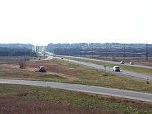
Iowa 141 turns east and passes through Aspinwall and Manning before meeting U.S. 71 south of Templeton. Iowa 141 and U.S. 71 run concurrent for 3 miles (4.8 km) before separating west of Dedham. It continues east, bypasses Dedham and turns southeast briefly before going east to go through Coon Rapids After another brief southeasterly turn, it goes east and passes through Bayard, where it meets Iowa Highway 25. They run together for 3 miles (4.8 km), then separate. After passing through Bagley, Iowa 141 meets Iowa Highway 4, with which it briefly runs concurrent. After passing south of Jamaica and Dawson, it meets Iowa Highway 144 in Perry and the highway turns into an expressway, which it will be for the rest of its length.
After passing through Perry, Iowa 141 continues east and meets U.S. 169 near Bouton. Near Woodward, it meets Iowa Highway 210 and turns southeast to go towards the Des Moines area. At Granger, it meets Iowa Highway 17 and shortly thereafter meets Iowa Highway 415, where it then turns south. It then passes through Grimes and meets Iowa Highway 44. It then enters Urbandale and quickly ends at an interchange with Interstate 35 and Interstate 80.
History
Iowa Highway 141 originally ran from Sioux City to Denison but was extended to the Des Moines area in 1941. In 1961, the highway was realigned so that it no longer entered Sioux City. The new segment went west from Smithland to Sloan, while the original segment from Smithland to Sioux City was designated (though not signed) as Iowa Highway 982. Between 1975 and 1977, Iowa Highway 141 was upgraded to a freeway between Perry and Interstates 35 and 80.[2]
Major intersections
| County | Location | mi[1] | km | Destinations | Notes |
|---|---|---|---|---|---|
| Woodbury | Sloan Township | 0.000 | 0.000 | ||
| Smithland | 16.276 | 26.194 | |||
| Monona | Mapleton | 24.503 | 39.434 | West end of Iowa 175 overlap | |
| 25.104 | 40.401 | East end of Iowa 175 overlap | |||
| Ute | 35.975 | 57.896 | |||
| Crawford | Goodrich–Denison township line | 52.755 | 84.901 | West end of US 59 overlap | |
| Denison | 54.701 | 88.033 | |||
| 55.358 | 89.090 | West end of US 30 overlap | |||
| 55.890 | 89.946 | East end of US 30 overlap | |||
| Washington Township | 62.983 | 101.361 | East end of US 59 overlap | ||
| Carroll | Eden Township | 83.947 | 135.100 | West end of US 71 overlap | |
| 86.939 | 139.915 | East end of US 71 overlap | |||
| Guthrie | Bayard | 105.213 | 169.324 | West end of Iowa 25 overlap | |
| Dodge Township | 108.225 | 174.171 | East end of Iowa 25 overlap | ||
| Richland Township | 114.728 | 184.637 | West end of Iowa 4 overlap | ||
| 115.174 | 185.355 | East end of Iowa 4 overlap | |||
| Dallas | Perry | 128.864 | 207.387 | ||
| Beaver Township | 132.947 | 213.957 | |||
| Woodward | 138.947 | 223.614 | |||
| Des Moines Township | 140.174 | 225.588 | |||
| Dallas–Polk county line | Granger | 146.815 | 236.276 | ||
| Polk | Jefferson Township | 148.977 | 239.755 | ||
| Grimes | 152.500 | 245.425 | |||
| Urbandale | 155.362 | 250.031 | |||
1.000 mi = 1.609 km; 1.000 km = 0.621 mi
| |||||
Notes
- While Highway 141 is the shortest and most direct route between Sioux City and Des Moines, it is not necessarily the fastest. Traveling via Interstates 29, 680, and 80 is approximately nine miles further, but it is possible to travel at higher speeds on the Interstates.
External links
- Iowa Highways Page: Highway 141.
- End of Iowa 141 at Iowa Highway Ends.
References
- 1 2 "2009 Volume of Traffic on the Primary Road System of Iowa" (PDF). Iowa Department of Transportation. January 1, 2009. Retrieved January 19, 2011.
- 1 2 Iowa Highways Page: Highway 141. Accessed 25 October 2006.