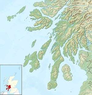
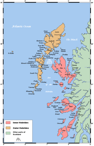
One of the Slate Islands, Seil (Scottish Gaelic: Saoil) is a small island on the east side of the Firth of Lorn, 7 miles (11 km) southwest of Oban, in Scotland. Seil has been linked to the mainland by bridge since the late 18th century.
Geography

From Ellenabeich village looking over Easdale Sound to
Scarba island in the distance.
Seil has been linked to the Scottish mainland since 1792 when the Clachan Bridge was built by engineer Robert Mylne. Also known as the "Bridge Over the Atlantic", the bridge is still used today and in early summer is covered in fairy foxgloves (Erinus alpinus).
Balvicar, in the centre of the island, is the main settlement with a flourishing fishing industry, the island shop, and a high percentage of houses that are occupied all year round. At the end of the road lies the former slate-mining village of Ellenabeich. This picturesque village is a conservation area with a high percentage of holiday cottages and is fully occupied only in the summer months. Parts of Ring of Bright Water were filmed here. The Ellenabeich Heritage Centre which opened in 2000, is run by the Scottish Slate Islands Trust. Located in a former slate quarry-worker's cottage, the centre has displays on life in the 19th century, slate quarrying and the local flora, fauna and geology.[6] Ferries sail from Ellenabeich to Easdale, and from Cuan on the island to Luing. The mother of Princess Diana, Frances Shand Kydd, lived there until her death in 2004.
Wildlife concerns
According to wildlife experts the entire badger population of the island may have been deliberately exterminated in 2007. Forty of the animals, whose setts were believed to be long established, may have been gassed to death, according to the police. The police also expressed concerns that two golden eagles and one white-tailed sea eagle have been found poisoned near Seil in recent years, involving use of the banned substance Carbofuran.[7][8]
History
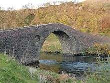
Fast-flowing sea water under the 18th century
Clachan Bridge that links Seil to mainland Scotland
Rae (2011) has argued that Seil could be the location of Hinba, an island associated with St Columba. His reasons include the island's association with St Brendan, its location on an inshore trade route from Antrim to the north and its suitability for a substantial settlement. He suggests that the Muirbolcmar (great sea bag) referred to in texts about Hinba could refer to the Seil Sound and narrows at Clachan Bridge where the "bag" captures the rapidly flowing water that floods under the bridge and also argues for this location on etymological grounds. Equating "Hinba" with the Gaelic Inbhir, he notes that the adjacent mainland parish of Kilninver means "church of Inbhir" and suggests that the derivation of "Seil" maybe of Scandinavian origin with similarities to the East Frisian place name Zijl or Syl meaning a "seep or passage of water". This, he proposes, could have been a Norse interpretation of Hinba/Inbhir.[9][Note 1]
It has also been suggested that Seil may be the Innisibsolian referred to in the Chronicle of the Kings of Alba, which records a victory of the Scots over a Viking force during the time of Donald II in the 9th century.[11]
Notes
- ↑ Mac an Tàilleir (2003) notes that Kilninver or Cill an Inbhir "appears to mean 'church by the river mouth', however an older form of Cill Fhionnbhair, 'Finbar's church' appears.[10]
References
- Hudson, Benjamin T. (October 1998) "The Scottish Chronicle". Scottish Historical Review. 77. Issue 204.
- Mac an Tàilleir, Iain (2003). "Placenames" (pdf). Pàrlamaid na h-Alba. Retrieved 23 July 2010.
- Rae, Robert J. "A Voyage in Search of Hinba" in Historic Argyll (2011) No. 16. Lorn Archaeological and Historical Society. Edited by J Overnell.
External links
 |
Wikimedia Commons has media related to Seil. |
|
|---|
|
| |
|
|
|
|
|
|
|
|
|
| Culture |
|---|
| | Shetland | |
|---|
| | Orkney | |
|---|
| | Outer Hebrides | |
|---|
| | Inner Hebrides | |
|---|
|
|
|
| Politics |
|---|
| | Local authorities | |
|---|
| | Serving MSPs | |
|---|
| | Serving MPs | |
|---|
| | Other | |
|---|
|
|
|
| Wildlife |
|---|
| | Fauna | |
|---|
| | Flora | |
|---|
| | Domesticated animals | |
|---|
|
|
|
|
Coordinates: 56°18′0″N 5°37′12″W / 56.30000°N 5.62000°W / 56.30000; -5.62000