Saint-Cyr-la-Rivière
| Saint-Cyr-la-Rivière | ||
|---|---|---|
|
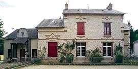
The school and town hall in Saint-Cyr-la-Rivière | ||
| ||
 Saint-Cyr-la-Rivière | ||
|
Location within Île-de-France region  Saint-Cyr-la-Rivière | ||
| Coordinates: 48°21′17″N 2°08′53″E / 48.3547°N 2.1481°ECoordinates: 48°21′17″N 2°08′53″E / 48.3547°N 2.1481°E | ||
| Country | France | |
| Region | Île-de-France | |
| Department | Essonne | |
| Arrondissement | Étampes | |
| Canton | Méréville | |
| Government | ||
| • Mayor (2008–2014) | Michelle Blanchard | |
| Area1 | 8.81 km2 (3.40 sq mi) | |
| Population (2006)2 | 499 | |
| • Density | 57/km2 (150/sq mi) | |
| Time zone | CET (UTC+1) | |
| • Summer (DST) | CEST (UTC+2) | |
| INSEE/Postal code | 91544 / 91690 | |
| Elevation | 72–146 m (236–479 ft) | |
|
1 French Land Register data, which excludes lakes, ponds, glaciers > 1 km² (0.386 sq mi or 247 acres) and river estuaries. 2 Population without double counting: residents of multiple communes (e.g., students and military personnel) only counted once. | ||
.svg.png)
Saint-Cyr-la-Rivière is a commune in the Essonne department in Île-de-France in northern France.
Inhabitants of Saint-Cyr-la-Rivière are known as Saint-Cyriens.
Geography
The village lies on the left bank of the Éclimont, which forms the commune's northeasern border and flows into the Juine, which flows northeast through the northwestern part of the commune.
See also
References
- INSEE
- Mayors of Essonne Association (French)
External links
| Wikimedia Commons has media related to Saint-Cyr-la-Rivière. |
- Mérimée database - Cultural heritage (French)
- Land use (IAURIF) (English)
This article is issued from Wikipedia - version of the 2/3/2015. The text is available under the Creative Commons Attribution/Share Alike but additional terms may apply for the media files.