Rivière-Saint-Jean, Gaspésie–Îles-de-la-Madeleine, Quebec
This article is about the unorganized territory in Gaspésie. For the municipality in Côte-Nord, see Rivière-Saint-Jean, Quebec.
| Rivière-Saint-Jean | |
|---|---|
| Unorganized territory | |
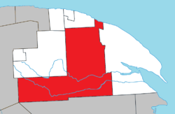 Location within La Côte-de-Gaspé RCM. | |
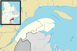 Rivière-Saint-Jean Location in eastern Quebec. | |
| Coordinates: 48°50′N 64°55′W / 48.833°N 64.917°WCoordinates: 48°50′N 64°55′W / 48.833°N 64.917°W[1] | |
| Country |
|
| Province |
|
| Region | Gaspésie–Îles-de-la-Madeleine |
| RCM | La Côte-de-Gaspé |
| Constituted | January 1, 1986 |
| Government[2] | |
| • Federal riding | Gaspésie—Îles-de-la-Madeleine |
| • Prov. riding | Gaspé |
| Area[2][3] | |
| • Total | 1,739.70 km2 (671.70 sq mi) |
| • Land | 1,751.46 km2 (676.24 sq mi) |
|
There is an apparent contradiction between two authoritative sources | |
| Population (2011)[3] | |
| • Total | 0 |
| • Density | 0.0/km2 (0/sq mi) |
| • Pop 2006-2011 |
|
| • Dwellings | 0 |
| Time zone | EST (UTC-5) |
| • Summer (DST) | EDT (UTC-4) |
| Highways |
|
Rivière-Saint-Jean is an unorganized territory in the Gaspésie–Îles-de-la-Madeleine region of Quebec, Canada. It is bisected by Quebec Route 198 that runs along the banks of the York River.
The territory is named after the Saint-Jean River that is considered one of the best salmon rivers in Quebec. This 90 kilometres (56 mi) long river has its source in the Chic-Choc Mountains, about 5 kilometres (3.1 mi) south of Murdochville, and runs in a south-east direction for the first 35 kilometres (22 mi), then east to the Bay of Gaspé. Portions of the river are protected in the Rivière-Saint-Jean Wildlife Reserve.[4]
Demographics
Population
| Historical Census Data - Rivière-Saint-Jean, Gaspésie–Îles-de-la-Madeleine, Quebec[5] | ||||||||||||||||||||||||
|---|---|---|---|---|---|---|---|---|---|---|---|---|---|---|---|---|---|---|---|---|---|---|---|---|
|
|
|
|
| ||||||||||||||||||||
See also
References
- ↑ Reference number 149671 of the Commission de toponymie du Québec (French)
- 1 2 "Rivière-Saint-Jean". Répertoire des municipalités (in French). Ministère des Affaires municipales, des Régions et de l'Occupation du territoire. Retrieved 2011-12-05.
- 1 2 "Rivière-Saint-Jean census profile". 2011 Census data. Statistics Canada. Retrieved 2011-12-05.
- ↑ "Rivière Saint-Jean" (in French). Commission de toponymie du Québec. Retrieved 2011-12-05.
- ↑ Statistics Canada: 1996, 2001, 2006, 2011 census
 |
Grande-Vallée | Cloridorme | Honguedo Strait | |
| Collines-du-Basque Mont-Albert |
|
Gaspé | ||
| ||||
| | ||||
| Rivière-Bonaventure | Mont-Alexandre |
| Cities | |
|---|---|
| Municipalities | |
| Townships | |
| Unorganized Territories | |
| |
This article is issued from Wikipedia - version of the 4/19/2014. The text is available under the Creative Commons Attribution/Share Alike but additional terms may apply for the media files.