Baía do Inferno
| Baía do Inferno | |
|---|---|
|
Satellite photograph of Santiago; the coastal indentation at lower left is the Baia do Inferno | |
| Location | Southwest of Pico da Antónia, south of Porto Rincão on the island of Santiago, Cape Verde |
| Coordinates | 15°00′37″N 23°43′54″W / 15.0102°N 23.7317°W |
| Max. length | 5 km |
| Max. width | 3 km |
| Average depth | around 100 meters |
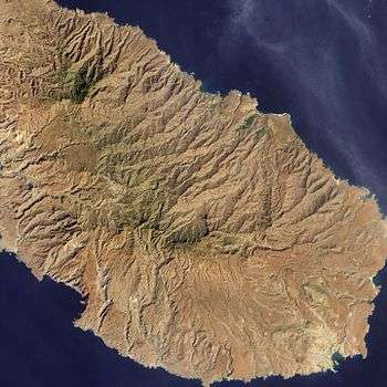
Baía do Inferno is a bay on the southwest coast of the island of Santiago in Cape Verde inside the Atlantic Ocean. The name means the bay of fire, as it was treacherous when the nearby island of Fogo erupted some several times. The bay is exclusively in the municipality of Santa Catarina, a kilometer east is Ribeira de Santa Clara and the municipal boundary with Ribeira Grande de Santiago.
About the bay
Its length is 5 km and its with is 3 km and is located around 3 km southeast of Porto Rincão and northwest of Porto Mosquito. Coastal cliffs is 100 meters in the outer portion, 200 meters in one portion and 400 meters in one eastern portion next to an extinct volcanic crater, the sea cliffs are the highest in Cape Verde and one of the highest in the Atlantic. No roads or trails passes within the vicinity of the bay due to its steep cliffs. Several streams flowing into the bay from north to south are Angra, Banana, Tabugal and Porco, two other streams unnamed and short flows into the bay. The nearby settlement northeast is Entre Picos de Reda.
The bay was formed 73,000 years ago when the eastern portion of the island of Fogo—a volume of approximately 100 cubic kilometres (24 cu mi) of rock—collapsed into the ocean generating a 170-metre (560 ft) high megatsunami. The surge inundated the western part of Santiago, running up to heights of 270 metres (890 ft) and carrying large boulders onto a plateau at an elevation of 200 metres (660 ft). During the Ice Age 10,000 years ago, the sea level was around 130 meters lower and the cliffs were 500 meters tall, the bay was 4 km wide. As the sea level rose to around the current levels around 2000 BC, the cliff heights were shortened and its width shrank to 3 km.
The bay forms a part of an Important Bird Area known as Coastal cliffs between Porto Mosquito and Baia do Inferno which includes the surrounding areas up to the limits of Rincão, the marine boundary extends to an area of a depth of 244 meters.[1][2]
References
- ↑ "Coastal cliffs between Porto Mosquito and Baia do Inferno". Important Bird Areas factsheet. BirdLife International. 2013. Archived from the original on 2007-07-10. Retrieved 2013-08-08.
- ↑ "Coastal cliffs between Porto Mosquito and Baia do Inferno - Marine". Important Bird Areas factsheet. BirdLife International. 2013. Archived from the original on 2007-07-10. Retrieved 2013-08-08.
Geography, features and topics of Santiago and the surrounding islets | ||
|---|---|---|
| Topics |
|  |
| Mountains |
| |
| Streams |
| |
| Points and promontories |
| |
| Reservoirs |
| |
| Other geographic features | ||
| History | ||
| Communities and settlements |  | |
|---|---|---|
| Geographical features | ||
| Landmarks and points of Interests | ||
| Culture | ||
Coordinates: 15°00′37″N 23°43′54″W / 15.0102°N 23.7317°W